
Make a donation
Gear up for your next adventure:
As an Amazon Associate, this site earns from qualifying purchases at no extra cost to you.
New Hampshire topographic map
Click on the map to display elevation.
Make a donation
Gear up for your next adventure:
As an Amazon Associate, this site earns from qualifying purchases at no extra cost to you.
New Hampshire
Average daytime highs are in the mid 70s°F to low 80s°F (24–28 °C) throughout the state in July, with overnight lows in the mid 50s°F to low 60s°F (13–15 °C). January temperatures range from an average high of 34 °F (1 °C) on the coast to overnight lows below 0 °F (−18 °C) in the far north and at high elevations. Average annual precipitation statewide is roughly 40 inches (100 cm) with some variation occurring in the White Mountains due to differences in elevation and annual snowfall. New Hampshire's highest recorded temperature was 106 °F (41 °C) in Nashua on July 4, 1911, while the lowest recorded temperature was −47 °F (−44 °C) atop Mount Washington on January 29, 1934. Mount Washington also saw an unofficial −50 °F (−46 °C) reading on January 22, 1885, which, if made official, would tie the record low for New England (also −50 °F (−46 °C) at Big Black River, Maine, on January 16, 2009, and Bloomfield, Vermont on December 30, 1933).
Make a donation
Gear up for your next adventure:
As an Amazon Associate, this site earns from qualifying purchases at no extra cost to you.
About this map
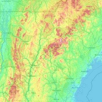
Name: New Hampshire topographic map, elevation, terrain.
Location: New Hampshire, United States (42.69723 -72.55724 45.30578 -70.56136)
Average elevation: 293 m
Minimum elevation: -4 m
Maximum elevation: 1,693 m
Make a donation
Gear up for your next adventure:
As an Amazon Associate, this site earns from qualifying purchases at no extra cost to you.
Other topographic maps
Click on a map to view its topography, its elevation and its terrain.
Little Saint James Island
United States > United States Virgin Islands > Saint Thomas - Saint John District
Average elevation: 1 m
Mendenhall Glacier
United States > Alaska > Juneau
The two small parking lots have access to several trails in the area. Photo Point Trail and the Steep Creek Trail are easy and accessible trails. Elevated boardwalks above Steep Creek provide salmon and bear viewing opportunities. Visitors can hike via the East Glacier Loop to an overlook within 1 mile (1,600…
Average elevation: 974 m
Make a donation
Gear up for your next adventure:
As an Amazon Associate, this site earns from qualifying purchases at no extra cost to you.
Make a donation
Gear up for your next adventure:
As an Amazon Associate, this site earns from qualifying purchases at no extra cost to you.
Glenmoore Local Open Space
United States > Maryland > Baltimore County > Cockeysville
Average elevation: 121 m
Make a donation
Gear up for your next adventure:
As an Amazon Associate, this site earns from qualifying purchases at no extra cost to you.
Sunshine Hill
United States > Pennsylvania > Fayette County > Nicholson Township
Average elevation: 294 m
Make a donation
Gear up for your next adventure:
As an Amazon Associate, this site earns from qualifying purchases at no extra cost to you.
Make a donation
Gear up for your next adventure:
As an Amazon Associate, this site earns from qualifying purchases at no extra cost to you.
Make a donation
Gear up for your next adventure:
As an Amazon Associate, this site earns from qualifying purchases at no extra cost to you.
Make a donation
Gear up for your next adventure:
As an Amazon Associate, this site earns from qualifying purchases at no extra cost to you.
Grand Mere State Park
United States > Michigan > Berrien County > Stevensville
Average elevation: 185 m
Make a donation
Gear up for your next adventure:
As an Amazon Associate, this site earns from qualifying purchases at no extra cost to you.
Mount Rainier
United States > Washington > Pierce County
Mount Rainier (/reɪˈnɪər/ ray-NEER), also known as Tahoma, is a large active stratovolcano in the Cascade Range of the Pacific Northwest in the United States. The mountain is located in Mount Rainier National Park about 59 miles (95 km) south-southeast of Seattle. With a summit elevation of 14,399.6 ft…
Average elevation: 3,912 m
Make a donation
Gear up for your next adventure:
As an Amazon Associate, this site earns from qualifying purchases at no extra cost to you.
Stony Creek
United States > Michigan > Washtenaw County > Augusta Charter Township
Average elevation: 228 m
Make a donation
Gear up for your next adventure:
As an Amazon Associate, this site earns from qualifying purchases at no extra cost to you.
Picking Conservation Land East
United States > Massachusetts > Middlesex County > Westford
Average elevation: 73 m
Make a donation
Gear up for your next adventure:
As an Amazon Associate, this site earns from qualifying purchases at no extra cost to you.
Make a donation
Gear up for your next adventure:
As an Amazon Associate, this site earns from qualifying purchases at no extra cost to you.
Make a donation
Gear up for your next adventure:
As an Amazon Associate, this site earns from qualifying purchases at no extra cost to you.
Bozrah Veterans Memorial
United States > Connecticut > Southeastern Connecticut Planning Region > Fitchville
Average elevation: 78 m
Denali's Fault. Scenic overlook
United States > Alaska > Unorganized Borough > Delta Junction
Average elevation: 379 m
South Woodstock
United States > Connecticut > Northeastern Connecticut Planning Region
Average elevation: 136 m
Make a donation
Gear up for your next adventure:
As an Amazon Associate, this site earns from qualifying purchases at no extra cost to you.
Wesley Chapel
United States > Florida > Pasco County
According to the United States Census Bureau, the CDP has a total area of 6.1 square miles (16 km2), of which 6.1 square miles (16 km2) is land and 0.04 square miles (0.10 km2) (0.49%) is water. The elevation is about 100 feet (30 m), combined with an inland location, creates more temperature variation in the…
Average elevation: 19 m
Make a donation
Gear up for your next adventure:
As an Amazon Associate, this site earns from qualifying purchases at no extra cost to you.
East Putnam
United States > Connecticut > Northeastern Connecticut Planning Region > Putnam
Average elevation: 148 m
Make a donation
Gear up for your next adventure:
As an Amazon Associate, this site earns from qualifying purchases at no extra cost to you.
Sanlando Springs
United States > Florida > Seminole County > Altamonte Springs
Average elevation: 25 m
Make a donation
Gear up for your next adventure:
As an Amazon Associate, this site earns from qualifying purchases at no extra cost to you.
Carrollwood
United States > Florida > Hillsborough County > Tampa
Carrollwood is located at 28.1 degrees north, 82.5 degrees west (28.0523, -82.4858). The elevation for the community is 39 feet (12 m) above sea level.
Average elevation: 16 m
Make a donation
Gear up for your next adventure:
As an Amazon Associate, this site earns from qualifying purchases at no extra cost to you.
Make a donation
Gear up for your next adventure:
As an Amazon Associate, this site earns from qualifying purchases at no extra cost to you.
Make a donation
Gear up for your next adventure:
As an Amazon Associate, this site earns from qualifying purchases at no extra cost to you.
Make a donation
Gear up for your next adventure:
As an Amazon Associate, this site earns from qualifying purchases at no extra cost to you.
Make a donation
Gear up for your next adventure:
As an Amazon Associate, this site earns from qualifying purchases at no extra cost to you.
Make a donation
Gear up for your next adventure:
As an Amazon Associate, this site earns from qualifying purchases at no extra cost to you.
Robbinsville
United States > New Jersey > Mercer County > Robbinsville Township
Average elevation: 32 m
Make a donation
Gear up for your next adventure:
As an Amazon Associate, this site earns from qualifying purchases at no extra cost to you.
Three Sisters
United States > Arizona > Navajo County
Monument Valley is part of the Colorado Plateau. The elevation of the valley floor ranges from 5,000 to 6,000 feet (1,500 to 1,800 m) above sea level. The floor is largely siltstone of the Cutler Group, or sand derived from it, deposited by the meandering rivers that carved the valley. The valley's vivid red…
Average elevation: 1,667 m
Make a donation
Gear up for your next adventure:
As an Amazon Associate, this site earns from qualifying purchases at no extra cost to you.