
Thailand topographic map
Interactive map
Click on the map to display elevation.
Thailand
Thailand comprises several distinct geographic regions, partly corresponding to the provincial groups. The north of the country is the mountainous area of the Thai highlands, with the highest point being Doi Inthanon in the Thanon Thong Chai Range at 2,565 metres (8,415 ft) elevation. The northeast, Isan, consists of the Khorat Plateau, bordered to the east by the Mekong River. The centre of the country is dominated by the predominantly flat Chao Phraya river valley, which runs into the Gulf of Thailand.
About this map
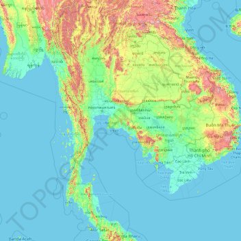
Name: Thailand topographic map, elevation, terrain.
Location: Thailand (5.61285 97.34381 20.46483 105.63681)
Average elevation: 156 m
Minimum elevation: -3 m
Maximum elevation: 2,557 m
Other topographic maps
Click on a map to view its topography, its elevation and its terrain.
Ban Phon Sawan
Thailand > Pathum Thani Province > Bueng Bon Subdistrict Administrative Organization > Bueng Bon Subdistrict
Average elevation: 4 m
Map Ta Phut
Thailand > Rayong Province > Rayong > Map Ta Phut > Ban Map Ta Phut
Average elevation: 26 m
Pruksa 44 Rangsit-Klong 2
Thailand > Pathum Thani Province > Pruksa 44 Rangsit-Klong 2
Average elevation: 4 m
Songkhla Province
The province is on the Malay Peninsula, on the coast of the Gulf of Thailand. The highest elevation is Khao Mai Kaeo at 821 meters.
Average elevation: 78 m
Phuket Province
Although some recent geographical works refer to the sections of the Tenasserim Hills in the isthmus as the "Phuket Range", these names are not found in classical geographic sources. Besides, the name Phuket is relatively recent having previously been named Jung Ceylon and Thalang. The highest elevation of the…
Average elevation: 25 m
Bangkok
Bangkok is in the Chao Phraya River delta in Thailand's central plain. The river meanders through the city in a southerly direction, emptying into the Gulf of Thailand approximately 25 kilometres (16 mi) south of city centre. The area is flat and low-lying, with an average elevation of 1.5 metres (4 ft 11 in)…
Average elevation: 4 m