
Spokane County topographic map
Interactive map
Click on the map to display elevation.
About this map
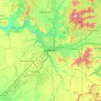
Name: Spokane County topographic map, elevation, terrain.
Location: Spokane County, Washington, United States (47.25927 -117.82370 48.04782 -117.03968)
Average elevation: 741 m
Minimum elevation: 418 m
Maximum elevation: 1,787 m
According to the United States Census Bureau, the county has a total area of 1,781 sq mi (4,610 km2), of which 17 square miles (44 km2) (0.9%) are covered by water. The lowest point in the county is the Spokane River behind Long Lake Dam (boundary of Stevens County) at 1,538 feet (469 m) above sea level. (Virtually no change in elevation occurs between the dam and the mouth of the Little Spokane River inside Riverside State Park.) The highest point in the county is the summit of Mount Spokane at 5,887 ft (1,794 m). NAVD 88
Other topographic maps
Click on a map to view its topography, its elevation and its terrain.
Everett
United States > Washington > Snohomish County
Everett, Snohomish County, Washington, United States
Average elevation: 66 m
Mount Vernon
United States > Washington > Skagit County
Mount Vernon, Skagit County, Washington, 98273, United States
Average elevation: 37 m
Puyallup
United States > Washington > Pierce County
Puyallup, Pierce County, Washington, United States
Average elevation: 66 m
Lynnwood
United States > Washington > Snohomish County
Lynnwood, Snohomish County, Washington, 98037, United States
Average elevation: 121 m
Whidbey Island
United States > Washington > Island County
Whidbey Island, Island County, Washington, United States
Average elevation: 45 m
Little Blue Lake
United States > Washington > Skamania County
Little Blue Lake, Skamania County, Washington, United States
Average elevation: 158 m
Quilcene
United States > Washington > Jefferson County > Quilcene
Quilcene, Jefferson County, Washington, United States
Average elevation: 268 m
South Cove Park
United States > Washington > King County > Issaquah
South Cove Park, Issaquah, King County, Washington, United States
Average elevation: 40 m
Raymond
United States > Washington > Pacific County
Raymond, Pacific County, Washington, 98577, United States
Average elevation: 67 m
Spokane
United States > Washington > Spokane County
Spokane, Spokane County, Washington, United States
Average elevation: 655 m
DuPont
United States > Washington > Pierce County
DuPont, Pierce County, Washington, 98327, United States
Average elevation: 65 m
Dungeness Spit
United States > Washington > Clallam County > Old Town
Dungeness Spit, Old Town, Clallam County, Washington, United States
Average elevation: 3 m
Maple Falls
United States > Washington > Whatcom County
Maple Falls, Whatcom County, Washington, United States
Average elevation: 442 m
Ellensburg
United States > Washington > Kittitas County
Ellensburg, Kittitas County, Washington, 98926, United States
Average elevation: 480 m
Covington
United States > Washington > King County
Covington, King County, Washington, 98042, United States
Average elevation: 137 m
Interlaken Park
United States > Washington > King County > Seattle
Interlaken Park, Capitol Hill, Seattle, King County, Washington, United States
Average elevation: 48 m
Sunshine Beach
United States > Washington > Pierce County
Sunshine Beach, Pierce County, Washington, 98394, United States
Average elevation: 47 m
Granite Falls
United States > Washington > Snohomish County
Granite Falls, Snohomish County, Washington, United States
Average elevation: 120 m
Graham
United States > Washington > Pierce County
Graham, Pierce County, Washington, 09339, United States
Average elevation: 205 m
Orting
United States > Washington > Pierce County
Orting, Pierce County, Washington, 98360, United States
Average elevation: 112 m
Wilson
United States > Washington > Lewis County
Wilson, Lewis County, Washington, United States
Average elevation: 358 m
Central Park
United States > Washington > Grays Harbor County
Central Park, Grays Harbor County, Washington, United States
Average elevation: 46 m
Lava Dome
United States > Washington > Skamania County
Lava Dome, Skamania County, Washington, United States
Average elevation: 2,109 m
Riverton
United States > Washington > King County > Tukwila
Riverton, Tukwila, King County, Washington, 98168, United States
Average elevation: 77 m
Ferndale
United States > Washington > Whatcom County
Ferndale, Whatcom County, Washington, United States
Average elevation: 29 m
Cake Rock
United States > Washington > Clallam County
Cake Rock, Clallam County, Washington, United States
Average elevation: 0 m
Pend Orielle River
United States > Washington > Pend Oreille County
Pend Orielle River, Pend Oreille County, Washington, 83822, United States
Average elevation: 1,060 m
Porter
United States > Washington > Grays Harbor County
Porter, Grays Harbor County, Washington, 98559, United States
Average elevation: 49 m
Soap Lake
United States > Washington > Grant County
Soap Lake, Grant County, Washington, 98851, United States
Average elevation: 352 m
Skull Rock
United States > Washington > San Juan County
Skull Rock, San Juan County, Washington, 98243, United States
Average elevation: 21 m
Jones Island
United States > Washington > San Juan County
Jones Island, San Juan County, Washington, United States
Average elevation: 6 m
Discovery Park
United States > Washington > Pierce County > Bonney Lake
Discovery Park, Bonney Lake, Pierce County, Washington, 98391, United States
Average elevation: 195 m
Ramapo
United States > Washington > Clallam County
Ramapo, Clallam County, Washington, United States
Average elevation: 114 m
Harbert
United States > Washington > Walla Walla County
Harbert, Walla Walla County, Washington, United States
Average elevation: 411 m
Brookdale
United States > Washington > Pierce County
Brookdale, Pierce County, Washington, 98445, United States
Average elevation: 128 m
Deer Valley
United States > Washington > Pend Oreille County
Deer Valley, Pend Oreille County, Washington, United States
Average elevation: 724 m
Martin
United States > Washington > Kittitas County
Martin, Kittitas County, Washington, United States
Average elevation: 893 m
Mill Creek
United States > Washington > Snohomish County
Mill Creek, Snohomish County, Washington, United States
Average elevation: 130 m
Richland
United States > Washington > Benton County
Richland, Benton County, Washington, United States
Average elevation: 160 m
Bellevue
United States > Washington > King County > Bellevue
Bellevue, King County, Washington, United States
Average elevation: 66 m
North Bend
United States > Washington > King County
North Bend, King County, Washington, United States
Average elevation: 160 m
Skagit River
United States > Washington > Whatcom County
Skagit River, Whatcom County, Washington, United States
Average elevation: 1,391 m
Kloke Peak (Hayden Peak)
United States > Washington > Whatcom County
Kloke Peak (Hayden Peak), Whatcom County, Washington, United States
Average elevation: 1,544 m
Myrtle Edwards Park
United States > Washington > King County > Seattle
Myrtle Edwards Park, Uptown, Belltown, Seattle, King County, Washington, United States
Average elevation: 22 m
Bothell
United States > Washington > King County
Bothell, King County, Washington, United States
Average elevation: 68 m
Disappointment
United States > Washington > Okanogan County
Disappointment, Okanogan County, Washington, United States
Average elevation: 1,980 m
Mukilteo
United States > Washington > Snohomish County
Mukilteo, Snohomish County, Washington, 98275, United States
Average elevation: 89 m
Mossyrock
United States > Washington > Lewis County
Mossyrock, Lewis County, Washington, United States
Average elevation: 213 m
Pullman
United States > Washington > Whitman County
Pullman, Whitman County, Washington, United States
Average elevation: 774 m
Kent
United States > Washington > King County
Kent, King County, Washington, United States
Average elevation: 87 m