
Deal Island topographic map
Interactive map
Click on the map to display elevation.
About this map
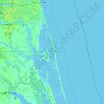
Name: Deal Island topographic map, elevation, terrain.
Location: Deal Island, Currituck County, North Carolina, United States (36.22571 -76.21131 36.86571 -75.57131)
Average elevation: 2 m
Minimum elevation: -3 m
Maximum elevation: 28 m
Other topographic maps
Click on a map to view its topography, its elevation and its terrain.
Wake County
United States > North Carolina
Wake County is located in the northeast central region of North Carolina, where the North American Piedmont and Atlantic Coastal Plain regions meet. This area is known as the "fall line" because it marks the elevation inland at which waterfalls begin to appear in creeks and rivers. As a result, most of Wake…
Average elevation: 96 m
Gaston County
United States > North Carolina
Crowders Mountain State Park is the largest natural heritage site in the county. It covers over 3,000 acres (12 km2) of topographically, botanically, and zoologically diverse land. Six natural plant communities are found in the park, and the area supports a diversity of wildlife species. Some animals…
Average elevation: 236 m
McDowell County
United States > North Carolina
Archaeological excavations performed by Dr. David Moore during the early 1980s, revealed artifacts and other evidence that the earliest inhabitants of McDowell County lived there from the Woodland period and Mississippian culture era, from 250 to 1500 AD. Dr. Moore discovered this material in an area close to…
Average elevation: 682 m
Charlotte
United States > North Carolina > Mecklenburg County
According to the United States Census Bureau, the city has a total area of 312.00 square miles (808.1 km2), of which 310.02 square miles (802.9 km2) is land and 1.98 square miles (5.1 km2) (0.63%) is water. Charlotte is the twenty-sixth-most expansive city in the United States and lies at an elevation of 751…
Average elevation: 207 m
Morrisville
United States > North Carolina > Wake County
Morrisville is located in the northeast central region of North Carolina, where the North American Piedmont and Atlantic Coastal Plain regions meet. This area is known as the "Fall Line" because it marks the elevation inland at which waterfalls begin to appear in creeks and rivers. As a result, most of…
Average elevation: 107 m
Macon County
United States > North Carolina
Cullasaja Falls is a waterfall in Southwestern North Carolina east of Franklin. The waterfall is located on the Cullasaja River in the Nantahala National Forest and is part of the Mountain Waters Scenic Byway. Cullasaja comes from a Cherokee word meaning "honey locust place." The falls is the last major…
Average elevation: 904 m
West Jefferson
United States > North Carolina > Ashe County
West Jefferson is a popular destination among tourists and retirees from Florida, as well as those from the lower elevations of the Carolinas and Georgia.
Average elevation: 1,002 m
Highlands
United States > North Carolina > Macon County
Highlands was founded in 1875 after its two founders, Samuel Truman Kelsey and Clinton Carter Hutchinson, drew lines from Chicago to Savannah and from New Orleans to New York City. They felt that the place where these lines met would eventually become a great trading center and commercial crossroads. Highlands…
Average elevation: 1,116 m
Mount Pleasant Water Lagoon
United States > North Carolina > Cabarrus County > Mount Pleasant
Average elevation: 203 m
Franklin
United States > North Carolina > Macon County
The height of the falls is given as 200 ft (61 m) in Kevin Adams' book, North Carolina Waterfalls and 250 ft (77.1 m) by NCWaterfalls.com. However, Google Earth gives a height (based on the elevation of the water at the top of the falls and the elevation of the plunge pool at the bottom of the falls) of 137 ft…
Average elevation: 675 m
Wake Forest
United States > North Carolina > Wake County
Wake Forest is located in the northeast-central region of North Carolina, where the North American Piedmont and Atlantic Coastal Plain regions meet. This area is known as the "Fall Line" because it marks the elevation inland at which waterfalls begin to appear in creeks and rivers. Its central Piedmont…
Average elevation: 105 m
Five Points Park
United States > North Carolina > Guilford County > High Point
Average elevation: 264 m
Newland
United States > North Carolina > Avery County
At an elevation of 3,621 feet or 1,104 metres, it is the highest county seat in the Eastern United States (based on elevations in the USGS database).
Average elevation: 1,140 m
Green Mill Run
United States > North Carolina > Pitt County > Greenville > Greenbrier
Average elevation: 21 m
Haywood County
United States > North Carolina
Haywood County is situated amidst the Blue Ridge Mountains and contains parts of several major subranges of the Blue Ridge, namely the Great Smoky Mountains in the west and the Plott Balsams and Great Balsam Mountains in the south. Notable peaks in the county include Cold Mountain, at 6,030 feet (1,840 m),…
Average elevation: 1,044 m
Watauga County
United States > North Carolina
Watauga County is extremely mountainous, and all of the county's terrain is located within the Appalachian Mountains range. The highest point in the county is Calloway Peak, the highest peak of Grandfather Mountain (shared with the adjacent counties of Avery and Caldwell), which rises to 5,964 feet (1,818…
Average elevation: 984 m
Graham County
United States > North Carolina
According to the U.S. Census Bureau, the county has a total area of 302 square miles (780 km2), of which 292 square miles (760 km2) is land and 9.6 square miles (25 km2) (3.2%) is water.[5] The terrain of the county is mountainous,[6] with elevations ranging from 1,177 feet (359 m) to 5,560 feet (1,690 m).…
Average elevation: 850 m
Chatham County
United States > North Carolina
The county lies totally within the Piedmont physiographic region. The topography of the county is generally gently rolling with several higher hills rising above the general terrain. One of these hills, Terrells Mountain, on the Orange County line is the transmitter site for several radio and TV stations for…
Average elevation: 132 m
Davidson County
United States > North Carolina
Davidson County is located entirely within the Piedmont region of central North Carolina. The Piedmont consists of gently rolling terrain frequently broken by hills or shallow valleys formed by rivers and streams. An exception to this terrain are the Uwharrie Mountains in the county's western and southwestern…
Average elevation: 222 m
Durham
United States > North Carolina > Durham County
Durham is located in the east-central part of the Piedmont region at 35°59′19″N 78°54′26″W / 35.98861°N 78.90722°W / 35.98861; -78.90722 (35.988644, −78.907167). Like much of the region, its topography is generally flat with some rolling hills.
Average elevation: 117 m
Annie Louise Wilkerson, MD Nature Preserve Park
United States > North Carolina
Average elevation: 106 m
Pamlico County
United States > North Carolina
The county was formed in 1872 from parts of Beaufort and Craven counties. It was named for Pamlico Sound, which adjoins it. Vernacular usage in the area, especially in Craven County, refers to Pamlico County as being "down in the county." Prior to 1872, it was a part of Craven County and has a very low…
Average elevation: 5 m
Robeson County
United States > North Carolina > Robeson County
The topography is mostly level to undulating coastal plain, largely made up of sandhills and coastal dunes with elevations above mean sea level that vary from 60 feet in the extreme southeastern portion of the county to 250 feet in the north, to the west of Parkton, North Carolina. Moreover, numerous swamps…
Average elevation: 44 m