
Dawson County topographic map
Interactive map
Click on the map to display elevation.
Dawson County
Part of Lake Lanier is in the southeastern part of the county and the boundary line with neighboring counties pass through the lake. The 729-foot (222 m) Amicalola Falls, are located in the county. The Amicalola Falls are the highest in Georgia, the tallest cascading waterfall east of the Mississippi River, and one of the Seven Natural Wonders of Georgia. The highest point in the county is Black Mountain, with an elevation of 3,600 feet (1,100 m). 6,760 acres (27.4 km2), which is located in the Chattahoochee National Forest. The Chestatee and Etowah rivers flow through Dawson County.
About this map
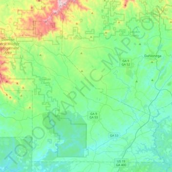
Name: Dawson County topographic map, elevation, terrain.
Location: Dawson County, Georgia, 30534, United States (34.33391 -84.34649 34.61763 -83.95747)
Average elevation: 461 m
Minimum elevation: 281 m
Maximum elevation: 1,141 m
Other topographic maps
Click on a map to view its topography, its elevation and its terrain.
Rivet Hill
United States > Georgia > Chattahoochee County > Chattahoochee County
Average elevation: 113 m
Atlanta
United States > Georgia > Fulton County
Atlanta (/ætˈlæntə/ at-LAN-tə) is the capital and most populous city of the U.S. state of Georgia. It is the seat of Fulton County, the most populous county in Georgia, but its territory falls in both Fulton and DeKalb counties. With a population of 498,715 living within the city limits, it is the eighth…
Average elevation: 285 m
Crestwood Estates
United States > Georgia > Athens-Clarke County > Athens-Clarke County Unified Government
Average elevation: 213 m
Mount Vernon
United States > Georgia > Richmond County > Augusta > Mount Vernon
Average elevation: 77 m
Stadium Walk
United States > Georgia > Bulloch County > Statesboro > Stadium Walk
Average elevation: 63 m