
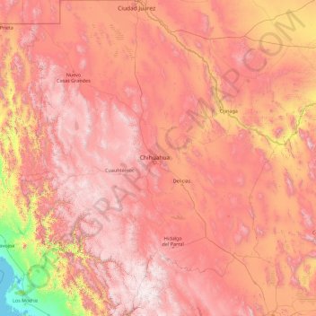
Chihuahua topographic map
Interactive map
Click on the map to display elevation.
About this map
Name: Chihuahua topographic map, elevation, terrain.
Location: Chihuahua, Mexico (25.55866 -109.07498 31.78390 -103.30669)
Average elevation: 1,397 m
Minimum elevation: -1 m
Maximum elevation: 3,119 m
The main mountain range in the state is the Sierra Madre Occidental reaching a maximum altitude of 10,826 ft (3,300 m) known as Cerro Mohinora. Mountains account for one third of the state's surface area which include large coniferous forests. The climate in the mountainous regions varies. Chihuahua has more forests than any other state in Mexico making the area a bountiful source of wood; the mountainous areas are rich in minerals important to Mexico's mining industry. Precipitation and temperature in the mountainous areas depends on the elevation. Between the months of November and March snow storms are possible in the lower elevations and are frequent in the higher elevations. There are several watersheds located in the Sierra Madre Occidental all of the water that flows through the state; most of the rivers finally empty into the Río Grande. Temperatures in some canyons in the state reach over 100 °F (38 °C) in the summer while the same areas rarely drop below 32 °F (0 °C) in the winter. Microclimates found in the heart of the Sierra Madre Occidental in the state could be considered tropical, and wild tropical plants have been found in some canyons. La Barranca del Cobre, or Copper Canyon, a spectacular canyon system larger and deeper than the Grand Canyon; the canyon also contains Mexico's two tallest waterfalls: Basaseachic Falls and Piedra Volada. There are two national parks found in the mountainous area of the state: Cumbres de Majalca National Park and Basaseachic Falls National Park.
Other topographic maps
Click on a map to view its topography, its elevation and its terrain.
Santiago Tianguistenco
Santiago Tianguistenco, Tianguistenco, 52600, Mexico
Average elevation: 2,645 m
Nevado de Toluca
Mexico > State of Mexico > Toluca
Nevado de Toluca, Toluca, State of Mexico, Mexico
Average elevation: 4,280 m
Naucalpan de Juárez
Naucalpan de Juárez, State of Mexico, Mexico
Average elevation: 2,366 m
Jilotepec
Jilotepec, State of Mexico, 54270, Mexico
Average elevation: 2,577 m
Huitznahuac
Mexico > State of Mexico > Chiautla
Huitznahuac, Chiautla, State of Mexico, 52270, Mexico
Average elevation: 2,253 m
Toluca
Mexico > State of Mexico > Toluca
Toluca, State of Mexico, 50000, Mexico
Average elevation: 2,729 m
Amealco de Bonfil
Mexico > Querétaro > Amealco de Bonfil
Amealco de Bonfil, Querétaro, Mexico
Average elevation: 2,631 m
COL. MADERAS
Mexico > Campeche > Carmen > Ciudad del Carmen
COL. MADERAS, Ciudad del Carmen, Carmen, Campeche, 24100, Mexico
Average elevation: 2 m
Jahuey Capula
Mexico > Hidalgo > Ixmiquilpan
Jahuey Capula, Ixmiquilpan, Hidalgo, Mexico
Average elevation: 1,780 m
Nezahualcóyotl
Nezahualcóyotl, State of Mexico, Mexico
Average elevation: 2,235 m
Islas Agrarias A
Mexico > Baja California > Municipio de Mexicali
Islas Agrarias A, Municipio de Mexicali, Baja California, 21972, Mexico
Average elevation: 12 m
Colonia Minerva
Mexico > Durango > Municipio de Durango
Colonia Minerva, Municipio de Durango, Durango, Mexico
Average elevation: 1,897 m
Lerma
Mexico > State of Mexico > Lerma
Lerma, State of Mexico, 52006, Mexico
Average elevation: 2,752 m
Mount Evermann
Mount Evermann, Tecomán, Colima, Mexico
Average elevation: 777 m
Aguascalientes
Mexico > Aguascalientes > Municipio de Aguascalientes
Aguascalientes, Municipio de Aguascalientes, Aguascalientes, 20000, Mexico
Average elevation: 1,956 m
El Mezquital
Mexico > Tamaulipas > Municipio de Matamoros
El Mezquital, Municipio de Matamoros, Tamaulipas, Mexico
Average elevation: 2 m
Parque Nacional Molino de Flores Netzahualcoyotl
Mexico > State of Mexico > Texcoco > Xocotlán
Parque Nacional Molino de Flores Netzahualcoyotl, Xocotlán, Texcoco, State of Mexico, Mexico
Average elevation: 2,313 m
Chihuahua
Mexico > Chihuahua > Municipio de Chihuahua
Chihuahua, Municipio de Chihuahua, Chihuahua, 31100, Mexico
Average elevation: 1,555 m
San Francisco del Rincón
Mexico > Guanajuato > San Francisco del Rincón
San Francisco del Rincón, Guanajuato, 36300, Mexico
Average elevation: 1,767 m
Los Garza
Mexico > Nuevo León > Agualeguas
Los Garza, Agualeguas, Nuevo León, Mexico
Average elevation: 233 m
El Nogal
Mexico > Nuevo León > Agualeguas
El Nogal, Agualeguas, Nuevo León, Mexico
Average elevation: 372 m
Los Nogales
Mexico > Nuevo León > Aramberri
Los Nogales, Aramberri, Nuevo León, Mexico
Average elevation: 1,168 m
Hacienda de Guadalupe
Mexico > Nuevo León > Los Herreras
Hacienda de Guadalupe, Los Herreras, Nuevo León, Mexico
Average elevation: 191 m
Parque de Bosques de Uganda
Mexico > State of Mexico > Nezahualcóyotl
Parque de Bosques de Uganda, Colonia Bosques de Aragón, Nezahualcóyotl, State of Mexico, 57170, Mexico
Average elevation: 2,229 m
Chetumal
Mexico > Quintana Roo > Othón P. Blanco
Chetumal, Othón P. Blanco, Quintana Roo, Mexico
Average elevation: 6 m
San Cristóbal Zapotitlán
Mexico > Jalisco > Jocotepec > San Cristóbal Zapotitlán
San Cristóbal Zapotitlán, Jocotepec, Jalisco, 45840, Mexico
Average elevation: 1,552 m
La Malinche
Mexico > Veracruz > Coatepec > Pacho Viejo > La Malinche
La Malinche, Pacho Viejo, Coatepec, Veracruz, 91602, Mexico
Average elevation: 1,193 m
Celaya
Mexico > Guanajuato > Celaya > Celaya
Celaya, Guanajuato, 38000, Mexico
Average elevation: 1,872 m