
Seal Rocks topographic map
Interactive map
Click on the map to display elevation.
About this map
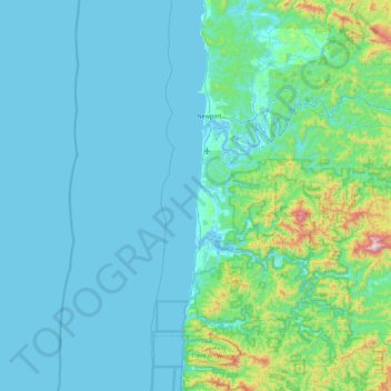
Name: Seal Rocks topographic map, elevation, terrain.
Location: Seal Rocks, Lincoln County, Oregon, 97376, United States (44.18563 -124.40485 44.82563 -123.76485)
Average elevation: 107 m
Minimum elevation: -4 m
Maximum elevation: 1,081 m
Other topographic maps
Click on a map to view its topography, its elevation and its terrain.
Salem
United States > Oregon > Marion County
Elevation within the city limits ranges from about 120 to 800 feet (37 to 244 m). Salem contains the volcanic Salem Hills in the south and is sandwiched by the 1,000 ft (300 m) Eola Hills directly to the west and the 600 ft (180 m) Waldo Hills to the east. Northern and eastern Salem are less hilly. South and…
Average elevation: 96 m
Harney County
Harney County has a "high desert" topography, with low levels of precipitation. About 500 ranches and farms producing cattle, dairy products and hay operate within the county; in the county, cattle outnumber people 14-to-1. Besides ranching and farming, forestry evolves important industries in the county.
Average elevation: 1,473 m
Crater Lake
United States > Oregon > Klamath County
The lake is 5 by 6 miles (8.0 by 9.7 km) across, with a caldera rim ranging in elevation from 7,000 to 8,000 feet (2,100 to 2,400 m) and an average lake depth of 1,148 feet (350 m). The lake's maximum depth has been measured at 1,949 feet (594 m), which fluctuates slightly as the weather changes. On the basis…
Average elevation: 1,971 m
Forest Park
United States > Oregon > Multnomah County > Portland
Solidified lava from Grande Ronde members of the Columbia River Basalt Group underlie Forest Park. About 16 million years ago during the Middle Miocene, the Columbia River ran through a lowland south of its modern channel. Eruptions from linear vents in eastern Oregon and Washington flowed down this channel…
Average elevation: 91 m
Hood River
United States > Oregon > Hood River County
Temperatures for the year as a whole are slightly cooler than in most other low-elevation towns in the region, especially at night because of air drainage off the surrounding mountains.
Average elevation: 112 m
Crooked River
The Lower Crooked Wild and Scenic River flows through 2,300 acres (930 ha) of public lands overseen by the Bureau of Land Management and 220 acres (89 ha) overseen by the Bureau of Reclamation. The Chimney Rock segment below Bowman Dam has nine developed campsites, seven of which are meant for single-family…
Average elevation: 1,131 m
Klamath Falls
United States > Oregon > Klamath County
According to the United States Census Bureau, the city has a total area of 20.66 square miles (53.51 km2), of which 19.81 square miles (51.31 km2) is land and 0.85 square miles (2.20 km2) is water. The elevation is 4,094 feet (1,248 m).
Average elevation: 1,312 m
Gresham
United States > Oregon > Multnomah County
Though much of Gresham is relatively flat, it is characterized by a hill on its eastern border. Northeast Gresham is also hilly, particularly where the city meets Troutdale toward the Columbia River. Its elevation is 325 feet (99 m). Johnson Creek, which begins at the foothills of the Cascade Mountains, runs…
Average elevation: 90 m
Bend
United States > Oregon > Deschutes County
The Deschutes River runs through Bend, where it is dammed to form Mirror Pond. Bend's elevation is 3,623 feet (1,104 metres) above sea level. The city has a total area of 33.27 square miles (86.17 square kilometres), of which 33.01 sq mi (85.50 km2) is land and 0.26 sq mi (0.67 km2) is water.
Average elevation: 1,121 m