Geolocate

Burke County topographic map

Interactive map

Click on the map to display elevation.

About this map

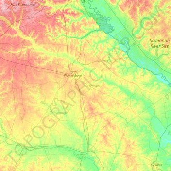
Name: Burke County topographic map, elevation, terrain.

Location: Burke County, Georgia, United States (32.80372 -82.31618 33.29700 -81.54186)

Average elevation: 75 m

Minimum elevation: 16 m

Maximum elevation: 166 m

Other topographic maps

Click on a map to view its topography, its elevation and its terrain.

Ithaca

United States > Georgia > Carroll County

Average elevation: 342 m

Rocky Face

United States > Georgia > Murray County

Average elevation: 712 m

Marion

United States > Georgia > Twiggs County

Average elevation: 115 m

The Lakes

United States > Georgia > Camden County > Kingsland

Average elevation: 7 m

South Fulton

United States > Georgia > Fulton County

Average elevation: 272 m

Piney Bluff

United States > Georgia > Camden County

Average elevation: 2 m

Thompson Dam

United States > Georgia > Dooly County

Average elevation: 123 m

Nevils

United States > Georgia > Bulloch County

Average elevation: 51 m

Pennant Hill

United States > Georgia > Glynn County

Average elevation: 5 m

Norman Park

United States > Georgia > Colquitt County

Average elevation: 100 m

Sandy

United States > Georgia > Butts County

Average elevation: 164 m

Atlanta

United States > Georgia > Fulton County

Atlanta (/ætˈlæntə/ at-LAN-tə) is the capital and most populous city of the U.S. state of Georgia. It is the seat of Fulton County, the most populous county in Georgia, but its territory falls in both Fulton and DeKalb counties. With a population of 498,715 living within the city limits, it is the eighth…

Average elevation: 285 m

Pine Mountain

United States > Georgia > Harris County

Average elevation: 274 m

Mary Cove

United States > Georgia > Rabun County

Average elevation: 602 m

Peachtree City

United States > Georgia > Peachtree City

Average elevation: 267 m

Hogan

United States > Georgia > Camden County

Average elevation: 3 m

Scott

United States > Georgia > Johnson County > Scott

Average elevation: 104 m

Toccoa

United States > Georgia > Stephens County > Toccoa > Toccoa

Average elevation: 299 m

Marietta

United States > Georgia > Cobb County > Marietta

Average elevation: 302 m

Gordon Park

United States > Georgia > Gordon Park

Average elevation: 42 m

Bryon Dam

United States > Georgia

Average elevation: 342 m

Skidaway Island

United States > Georgia

Average elevation: 3 m

Vineyard Creek

United States > Georgia > Vineyard Creek

Average elevation: 188 m

Waters Creek

United States > Georgia > Lumpkin County

Average elevation: 663 m