
Shefa Province topographic map
Interactive map
Click on the map to display elevation.
About this map
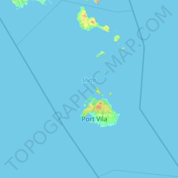
Name: Shefa Province topographic map, elevation, terrain.
Location: Shefa Province, Vanuatu (-18.35001 167.46060 -16.50000 169.31327)
Average elevation: 6 m
Minimum elevation: 0 m
Maximum elevation: 1,285 m
Other topographic maps
Click on a map to view its topography, its elevation and its terrain.
Mele Island
Vanuatu > Shefa Province > Mele
Mele Island, Mele, Shefa Province, Vanuatu
Average elevation: 2 m
Pukura
Vanuatu > Shefa Province > Port Vila
Pukura, Port Vila, Shefa Province, Vanuatu
Average elevation: 62 m
Lombaha Pasis
Lombaha Pasis, Lombaha, Penama, Vanuatu
Average elevation: 81 m
Aore Island
Vanuatu > Sanma > Luganville
Aore Island, Luganville, Sanma, Vanuatu
Average elevation: 33 m
Cook Reef
Vanuatu > Shefa Province > Port Vila
Cook Reef, Port Vila, Shefa Province, Vanuatu
Average elevation: 0 m