
Tafea topographic map
Interactive map
Click on the map to display elevation.
About this map
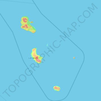
Name: Tafea topographic map, elevation, terrain.
Location: Tafea, Vanuatu (-20.46274 168.35376 -18.27167 170.44998)
Average elevation: 7 m
Minimum elevation: 0 m
Maximum elevation: 972 m
The island of Tanna has the world's most accessible volcano, Mount Yasur, with 1,084 meters the highest peak of the province. Aniwa Island is the only coral island, the other four are volcanic and reach much higher elevations than Aniwa.
Other topographic maps
Click on a map to view its topography, its elevation and its terrain.
Mele Island
Vanuatu > Shefa Province > Mele
Mele Island, Mele, Shefa Province, Vanuatu
Average elevation: 2 m
Pukura
Vanuatu > Shefa Province > Port Vila
Pukura, Port Vila, Shefa Province, Vanuatu
Average elevation: 62 m
Lombaha Pasis
Lombaha Pasis, Lombaha, Penama, Vanuatu
Average elevation: 81 m
Aore Island
Vanuatu > Sanma > Luganville
Aore Island, Luganville, Sanma, Vanuatu
Average elevation: 33 m
Cook Reef
Vanuatu > Shefa Province > Port Vila
Cook Reef, Port Vila, Shefa Province, Vanuatu
Average elevation: 0 m