
Grisons topographic map
Interactive map
Click on the map to display elevation.
About this map
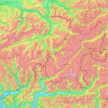
Name: Grisons topographic map, elevation, terrain.
Location: Grisons, Switzerland (46.16918 8.65106 47.06515 10.49229)
Average elevation: 1,737 m
Minimum elevation: 189 m
Maximum elevation: 4,001 m
The Grisons lies fully within the Alps, with elevations above sea-level ranging from 260 to 4,049 metres (853 to 13,284 ft). It is both one of the highest and lowest cantons, and the second-highest when considering mean elevation. As a consequence, its topography is extremely rugged and many of the highest settlements in the country (and Europe) are found there, notably in the Upper Engadin. The mountains are numerous; well over 1,000 summits are in the canton. The highest is Piz Bernina, closely followed by numerous peaks in the homonymous range. Other prominent mountains are Piz Russein, Piz Kesch, Calanda, Aroser Rothorn and Rheinwaldhorn, see list of mountains of Graubünden for a more exhaustive list. The canton includes numerous subranges of the Alps other than the Bernina. These are the Albula, the Bregaglia, the Glarus, the Gotthard, the Lepontine, the Livigno, the Plessur, the Oberhalbstein, the Ortler, the Rätikon, the Samnaun, the Sesvenna and the Silvretta ranges.
Other topographic maps
Click on a map to view its topography, its elevation and its terrain.
Flums
Switzerland > St. Gallen > Wahlkreis Sarganserland
Flums, Wahlkreis Sarganserland, St. Gallen, Switzerland
Average elevation: 1,328 m
Château-d'Oex
Switzerland > Vaud > District de la Riviera-Pays-d’Enhaut
Château-d'Oex, District de la Riviera-Pays-d’Enhaut, Vaud, 1660, Switzerland
Average elevation: 1,479 m
Corcelles (BE)
Switzerland > Bern > Bernese Jura administrative district
Corcelles (BE), Bernese Jura administrative district, Bernese Jura administrative region, Bern, 2747, Switzerland
Average elevation: 907 m
Wil (SG)
Switzerland > St. Gallen > Wahlkreis Wil
Wil (SG), Wahlkreis Wil, St. Gallen, Switzerland
Average elevation: 590 m
Grindelwald
Switzerland > Bern > Interlaken-Oberhasli administrative district
Grindelwald, Interlaken-Oberhasli administrative district, Oberland administrative region, Bern, 3818, Switzerland
Average elevation: 2,218 m
Ormont-Dessus
Switzerland > Vaud > District d'Aigle
Ormont-Dessus, District d'Aigle, Vaud, Switzerland
Average elevation: 1,864 m
Madulain
Switzerland > Grisons > Maloja
Madulain, Maloja, Grisons, 7523, Switzerland
Average elevation: 2,330 m
Lauterbrunnen
Switzerland > Bern > Interlaken-Oberhasli administrative district
Lauterbrunnen, Interlaken-Oberhasli administrative district, Oberland administrative region, Bern, Switzerland
Average elevation: 2,316 m
Trub
Switzerland > Bern > Emmental administrative district
Trub, Emmental administrative district, Emmental-Oberaargau administrative region, Bern, Switzerland
Average elevation: 990 m
Schloss Wittigkofen
Switzerland > Bern > Bern-Mittelland administrative district > Bern > Schloss Wittigkofen
Schloss Wittigkofen, Wittigkofenweg, Wittigkofen, Murifeld, Schloss Wittigkofen, Stadtteil IV, Bern, Bern-Mittelland administrative district, Bernese Mittelland administrative region, Bern, 3006, Switzerland
Average elevation: 568 m
Kiental
Switzerland > Bern > Frutigen-Niedersimmental administrative district > Reichenbach im Kandertal
Kiental, Reichenbach im Kandertal, Frutigen-Niedersimmental administrative district, Oberland administrative region, Bern, 3723, Switzerland
Average elevation: 1,363 m
Bruederhus
Switzerland > Aargau > Bezirk Aarau > Oberentfelden
Bruederhus, Oberentfelden, Bezirk Aarau, Aargau, 5036, Switzerland
Average elevation: 450 m
Bussigny
Switzerland > Vaud > District de l'Ouest lausannois
Bussigny, District de l'Ouest lausannois, Vaud, 1030, Switzerland
Average elevation: 440 m
Hinterrhein
Switzerland > Grisons > Viamala
Hinterrhein, Viamala, Grisons, Switzerland
Average elevation: 1,782 m
Ramosch
Switzerland > Grisons > Region Engiadina Bassa/Val Müstair > Valsot
Ramosch, Valsot, Region Engiadina Bassa/Val Müstair, Grisons, 7556, Switzerland
Average elevation: 1,501 m
Wengen
Switzerland > Bern > Interlaken-Oberhasli administrative district
Wengen, Lauterbrunnen, Interlaken-Oberhasli administrative district, Oberland administrative region, Bern, 3823, Switzerland
Average elevation: 1,450 m
Strandweg
Switzerland > St. Gallen > Wahlkreis See-Gaster > Rapperswil-Jona > Rapperswil
Strandweg, Rapperswil, Rapperswil-Jona, Wahlkreis See-Gaster, St. Gallen, 8640, Switzerland
Average elevation: 408 m
Saignelégier
Switzerland > Jura > District des Franches-Montagnes
Saignelégier, District des Franches-Montagnes, Jura, Switzerland
Average elevation: 862 m
Worb
Switzerland > Bern > Bern-Mittelland administrative district
Worb, Bern-Mittelland administrative district, Bernese Mittelland administrative region, Bern, Switzerland
Average elevation: 666 m
Breitenbach
Switzerland > Solothurn > Amtei Dorneck-Thierstein
Breitenbach, Bezirk Thierstein, Amtei Dorneck-Thierstein, Solothurn, 4226, Switzerland
Average elevation: 467 m
Saanen
Switzerland > Bern > Obersimmental-Saanen administrative district
Saanen, Obersimmental-Saanen administrative district, Oberland administrative region, Bern, Switzerland
Average elevation: 1,526 m
Gingins
Switzerland > Vaud > District de Nyon
Gingins, District de Nyon, Vaud, 1276, Switzerland
Average elevation: 773 m
Rapperswil
Switzerland > St. Gallen > Wahlkreis See-Gaster > Rapperswil-Jona
Rapperswil, Rapperswil-Jona, Wahlkreis See-Gaster, St. Gallen, 8640, Switzerland
Average elevation: 448 m
Winterthur
Switzerland > Zurich > Bezirk Winterthur
Winterthur, Bezirk Winterthur, Zurich, Switzerland
Average elevation: 504 m
Kloten
Switzerland > Zurich > Bezirk Bülach
Kloten, Bezirk Bülach, Zurich, 8302, Switzerland
Average elevation: 478 m
Le Grand-Saconnex
Le Grand-Saconnex, Geneva, 1218, Switzerland
Average elevation: 429 m
Provence
Switzerland > Vaud > District du Jura-Nord vaudois
Provence, District du Jura-Nord vaudois, Vaud, 1428, Switzerland
Average elevation: 971 m
Tschierv
Switzerland > Grisons > Region Engiadina Bassa/Val Müstair > Val Müstair
Tschierv, Val Müstair, Region Engiadina Bassa/Val Müstair, Grisons, 7532, Switzerland
Average elevation: 2,023 m
Muri bei Bern
Switzerland > Bern > Bern-Mittelland administrative district
Muri bei Bern, Bern-Mittelland administrative district, Bernese Mittelland administrative region, Bern, Switzerland
Average elevation: 568 m
Couronne de Bréona
Switzerland > Wallis > Sierre > Anniviers
Couronne de Bréona, Anniviers, Sierre, Wallis, 3961, Switzerland
Average elevation: 2,720 m
Gstaad
Switzerland > Bern > Obersimmental-Saanen administrative district
Gstaad, Saanen, Obersimmental-Saanen administrative district, Oberland administrative region, Bern, 3780, Switzerland
Average elevation: 1,242 m
Hospental
Switzerland > Uri > Korporation Ursern > Hospental
Hospental, Korporation Ursern, Uri, 6493, Switzerland
Average elevation: 2,144 m
Contra
Switzerland > Ticino > Distretto di Locarno > Contra
Contra, Tenero-Contra, Circolo della Navegna, Distretto di Locarno, Ticino, 6598, Switzerland
Average elevation: 543 m
Oberrüti
Switzerland > Zurich > Bezirk Bülach > Winkel > Oberrüti
Oberrüti, Winkel, Bezirk Bülach, Zurich, 8185, Switzerland
Average elevation: 481 m
Eggerberg
Switzerland > Valais/Wallis > Eggerberg
Eggerberg, Brig, Valais/Wallis, 3939, Switzerland
Average elevation: 1,371 m