
Make a donation
Gear up for your next adventure:
As an Amazon Associate, this site earns from qualifying purchases at no extra cost to you.
Pahang topographic map
Click on the map to display elevation.
Make a donation
Gear up for your next adventure:
As an Amazon Associate, this site earns from qualifying purchases at no extra cost to you.
Pahang
The highest peak, Mount Tahan, reaches 2,187 m (7,175 ft) in elevation, which is also the highest point in the Peninsular Malaysia. The climate is temperate enough to have distinct temperature variations year round, and much of the highlands are covered with tropical rainforest. Pahang is home to Malaysia's two important national parks, Taman Negara and Endau-Rompin, both located in the north and south of the state respectively. These large primary rainforests are extensive, and are home to many rare or endangered animals, such as the tapir, kancil, tigers, elephants and leopards. Ferns are also extremely common, mainly due to the high humidity and fog that permeates the area. Popular hill resorts located along these main highland areas are Cameron Highlands, Genting Highlands, Fraser's Hill and Bukit Tinggi. The Cameron Highlands is home to extensive tea plantations and also a major supplier of legumes and vegetables to both Malaysia and Singapore. The largest FELDA's palm oil plantations in Malaysia are located in Jengka Triangle centred around the Bandar Tun Razak in Maran district.
Make a donation
Gear up for your next adventure:
As an Amazon Associate, this site earns from qualifying purchases at no extra cost to you.
About this map
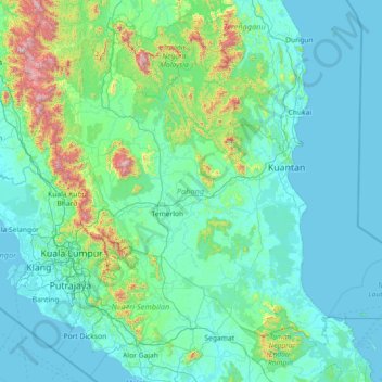
Name: Pahang topographic map, elevation, terrain.
Location: Pahang, Malaysia (2.45829 101.33159 4.78112 104.22334)
Average elevation: 164 m
Minimum elevation: -2 m
Maximum elevation: 2,125 m
Make a donation
Gear up for your next adventure:
As an Amazon Associate, this site earns from qualifying purchases at no extra cost to you.
Other topographic maps
Click on a map to view its topography, its elevation and its terrain.
Tioman Island
Local mythology claims that the island is the embodiment of the mighty dragon Sri Gumom. The dragon was on his way to visit his sister Gunung Linga (Lingin Peak) but the great Sri Rama forbade the meeting and Sri Gumom was turned into a stone and fell into the deep sea where he now remains, frozen in eternity…
Average elevation: 104 m
Malacca
The state of Malacca covers an area of 1,664 km2 (642 sq mi). It sits upon the southwestern coast of the Malay Peninsula opposite Sumatra, with the state of Negeri Sembilan to the north and west and Johor to the east. Malacca is situated roughly two-thirds of the way down the west coast, 148 km (92 mi) south…
Average elevation: 82 m
Federal Territory of Kuala Lumpur
Located in the centre of Selangor state, Kuala Lumpur was a territory of Selangor State Government. In 1974, Kuala Lumpur was split off from Selangor to form the first Federal Territory governed directly by the Malaysian federal government. Its location in the most developed state on the west coast of…
Average elevation: 119 m
Make a donation
Gear up for your next adventure:
As an Amazon Associate, this site earns from qualifying purchases at no extra cost to you.
Mount Tahan
Mount Tahan (Malay: Gunung Tahan), is the highest point in Peninsular Malaysia with an elevation of 7,175 ft (2,187 m) above sea level, on the border between the states of Pahang and Kelantan, with the peak lying on the Pahangese side. It is part of the Taman Negara that straddles Jerantut District in Pahang,…
Average elevation: 1,829 m
Make a donation
Gear up for your next adventure:
As an Amazon Associate, this site earns from qualifying purchases at no extra cost to you.
Penang Hill
Malaysia > Penang > George Town > Ayer Itam
A number of hills are covered by Penang Hill, with the highest point being Western Hill that stands at an altitude of 833 meters (2,733 feet) above sea level. Penang Hill is a hilly and forested area that stands out from the lowlands of Malaysia by being hilly and wooded. The area was used as a retreat during…
Average elevation: 436 m
Make a donation
Gear up for your next adventure:
As an Amazon Associate, this site earns from qualifying purchases at no extra cost to you.
Make a donation
Gear up for your next adventure:
As an Amazon Associate, this site earns from qualifying purchases at no extra cost to you.
Tambunan
Tambunan (Malay: Pekan Tambunan) is the capital of the Tambunan District in the Interior Division of Sabah, Malaysia. Its population was estimated to be around 35,667 in 2010. It is located 80 kilometres east of the state capital, Kota Kinabalu (to which is connected by the Kota Kinabalu-Tambunan-Keningau…
Average elevation: 697 m
Gaya Island
Malaysia > Sabah > Kota Kinabalu
Gaya Island (Malay: Pulau Gaya) is a sizeable Malaysian island of 1,465 ha, just 10 minutes off Kota Kinabalu, Sabah and forms part of the Tunku Abdul Rahman National Park. Gaya Island derived its name from the Bajau word "Gayo" which means big and occupies an area of 15 km² (3,700 acres) with an elevation of…
Average elevation: 34 m
Make a donation
Gear up for your next adventure:
As an Amazon Associate, this site earns from qualifying purchases at no extra cost to you.
Make a donation
Gear up for your next adventure:
As an Amazon Associate, this site earns from qualifying purchases at no extra cost to you.
Make a donation
Gear up for your next adventure:
As an Amazon Associate, this site earns from qualifying purchases at no extra cost to you.
Make a donation
Gear up for your next adventure:
As an Amazon Associate, this site earns from qualifying purchases at no extra cost to you.
Make a donation
Gear up for your next adventure:
As an Amazon Associate, this site earns from qualifying purchases at no extra cost to you.