
Federal Territory of Kuala Lumpur topographic map
Interactive map
Click on the map to display elevation.
Federal Territory of Kuala Lumpur
Located in the centre of Selangor state, Kuala Lumpur was a territory of Selangor State Government. In 1974, Kuala Lumpur was split off from Selangor to form the first Federal Territory governed directly by the Malaysian federal government. Its location in the most developed state on the west coast of peninsular Malaysia, which has a wider stretch of flat land than the east coast, has helped it develop faster than other cities in Malaysia. The municipality covers an area of 243 km2 (94 sq mi), with an average elevation of 81.95 m (268 ft 10 in) highest point being Bukit Nanas at 94 meters above sea level.
About this map
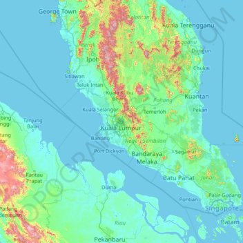
Name: Federal Territory of Kuala Lumpur topographic map, elevation, terrain.
Location: Federal Territory of Kuala Lumpur, Malaysia (0.55266 99.10222 5.75266 104.30222)
Average elevation: 119 m
Minimum elevation: -3 m
Maximum elevation: 2,169 m
Other topographic maps
Click on a map to view its topography, its elevation and its terrain.
Cameron Highlands
Surveyed by the government geologist and explorer William Cameron in 1885, the outpost consists of three mukims (subdistricts), namely Ringlet, Tanah Rata and Ulu Telom. Its eight settlements are Ringlet, Tanah Rata (the administrative centre), Brinchang, the Bertam Valley, Kea Farm, Tringkap, Kampung Kuala…
Average elevation: 1,117 m
Perak
In 1959, a British artillery officer stationed at an inland army base during the Malayan Emergency discovered the Tambun rock art, identified by archaeologists as the largest rock art site in the Malay Peninsula. Most of the paintings are located high above the cave floor, at an elevation of 6–10 metres…
Average elevation: 251 m
Penang Hill
Malaysia > Penang > George Town > Ayer Itam
A number of hills are covered by Penang Hill, with the highest point being Western Hill that stands at an altitude of 833 meters (2,733 feet) above sea level. Penang Hill is a hilly and forested area that stands out from the lowlands of Malaysia by being hilly and wooded. The area was used as a retreat during…
Average elevation: 436 m
George Town
The jurisdiction of George Town covers an area of approximately 306 km2 (118 sq mi), encompassing the entirety of Penang Island and nine surrounding islets. George Town is slightly more than two-fifths the size of Singapore. The 295 km2 (114 sq mi) Penang Island has an uneven terrain with a mountainous…
Average elevation: 52 m
Pahang
The highest peak, Mount Tahan, reaches 2,187 m (7,175 ft) in elevation, which is also the highest point in the Peninsular Malaysia. The climate is temperate enough to have distinct temperature variations year round, and much of the highlands are covered with tropical rainforest. Pahang is home to Malaysia's…
Average elevation: 164 m
Tioman Island
Local mythology claims that the island is the embodiment of the mighty dragon Sri Gumom. The dragon was on his way to visit his sister Gunung Linga (Lingin Peak) but the great Sri Rama forbade the meeting and Sri Gumom was turned into a stone and fell into the deep sea where he now remains, frozen in eternity…
Average elevation: 104 m
Selayang Municipal Council
Given its varied topography pattern and close proximity to the Titiwangsa Mountains (Banjaran Titiwangsa), Selayang is a mix of urban and countryside sceneries. Its premier natural attraction, which is well known across the country, is the Forest Research Institute Malaysia (FRIM), also known as FRIM Kepong.…
Average elevation: 236 m
Gaya Island
Malaysia > Sabah > Kota Kinabalu
Gaya Island (Malay: Pulau Gaya) is a sizeable Malaysian island of 1,465 ha, just 10 minutes off Kota Kinabalu, Sabah and forms part of the Tunku Abdul Rahman National Park. Gaya Island derived its name from the Bajau word "Gayo" which means big and occupies an area of 15 km² (3,700 acres) with an elevation of…
Average elevation: 34 m