
Crows Nest topographic map
Interactive map
Click on the map to display elevation.
About this map
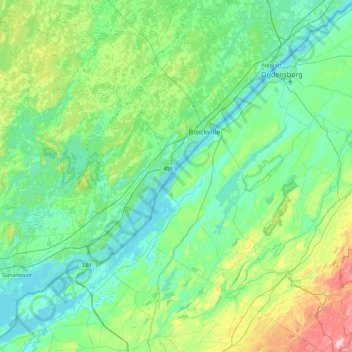
Name: Crows Nest topographic map, elevation, terrain.
Location: Crows Nest, Saint Lawrence County, New York, United States (44.18839 -76.07580 44.82839 -75.43580)
Average elevation: 114 m
Minimum elevation: 72 m
Maximum elevation: 298 m
Other topographic maps
Click on a map to view its topography, its elevation and its terrain.
New York County
United States > New York > New York
New York County, New York, United States
Average elevation: 16 m
Preston Center
United States > New York > Chenango County
Preston Center, Town of Preston, Chenango County, New York, United States
Average elevation: 455 m
City of Schenectady
United States > New York > Schenectady County
City of Schenectady, Schenectady County, New York, 12345, United States
Average elevation: 100 m
City of Niagara Falls
United States > New York > Niagara County
City of Niagara Falls, Niagara County, New York, United States
Average elevation: 180 m
Lake George
United States > New York > Warren County > Town of Bolton
Lake George, Town of Bolton, Warren County, New York, United States
Average elevation: 247 m
City of Albany
United States > New York > Albany County
City of Albany, Albany County, New York, United States
Average elevation: 68 m
Springs
United States > New York > Suffolk County
Springs, Town of East Hampton, Suffolk County, New York, United States
Average elevation: 6 m
Orient
United States > New York > Suffolk County > Town of Southold
Orient, Town of Southold, Suffolk County, New York, United States
Average elevation: 2 m
Miller Place
United States > New York > Suffolk County > Town of Brookhaven
Miller Place, Town of Brookhaven, Suffolk County, New York, 11764, United States
Average elevation: 34 m
City of Auburn
United States > New York > Cayuga County
City of Auburn, Cayuga County, New York, 13021, United States
Average elevation: 209 m
Rudeston
United States > New York > Hamilton County
Rudeston, Town of Arietta, Hamilton County, New York, United States
Average elevation: 533 m
Town of Perry
United States > New York > Wyoming County
Town of Perry, Wyoming County, New York, 14530, United States
Average elevation: 403 m
City of Ogdensburg
United States > New York > Saint Lawrence County
City of Ogdensburg, Saint Lawrence County, New York, United States
Average elevation: 85 m
Terpening Corners
United States > New York > Tompkins County > South Lansing
Terpening Corners, South Lansing, Town of Lansing, Tompkins County, New York, United States
Average elevation: 288 m
Sequoia Tree
United States > New York > New York County > New York
Sequoia Tree, Morningside Avenue, Manhattan Community Board 9, Manhattan, New York County, New York, 10027, United States
Average elevation: 19 m
Cecil Park
United States > New York > Westchester County > City of Yonkers
Cecil Park, City of Yonkers, Westchester County, New York, 10707, United States
Average elevation: 70 m
Roslyn Heights
United States > New York > Nassau County
Roslyn Heights, Town of North Hempstead, Nassau County, New York, United States
Average elevation: 48 m
Village of Potsdam
United States > New York > Saint Lawrence County > Town of Potsdam
Village of Potsdam, Town of Potsdam, Saint Lawrence County, New York, 13699, United States
Average elevation: 133 m
Village of Mill Neck
United States > New York > Nassau County
Village of Mill Neck, Town of Oyster Bay, Nassau County, New York, 11765, United States
Average elevation: 19 m
Village of Middleville
United States > New York > Herkimer County
Village of Middleville, Town of Fairfield, Herkimer County, New York, United States
Average elevation: 227 m
Tillson
United States > New York > Ulster County > Town of Rosendale
Tillson, Town of Rosendale, Ulster County, New York, 12486, United States
Average elevation: 58 m
Cuddebackville
United States > New York > Orange County
Cuddebackville, Town of Deerpark, Orange County, New York, 12729, United States
Average elevation: 216 m
Town of Monroe
United States > New York > Orange County
Town of Monroe, Orange County, New York, United States
Average elevation: 229 m
Chester Heights
United States > New York > Westchester County > City of New Rochelle
Chester Heights, City of New Rochelle, Westchester County, New York, 10801, United States
Average elevation: 36 m
North Patchogue
United States > New York > Suffolk County > Town of Brookhaven
North Patchogue, Town of Brookhaven, Suffolk County, New York, United States
Average elevation: 15 m
Village of Thomaston
United States > New York > Nassau County
Village of Thomaston, Town of North Hempstead, Nassau County, New York, United States
Average elevation: 35 m
Horton Falls
United States > New York > Albany County > Town of New Scotland
Horton Falls, Town of New Scotland, Albany County, New York, 12159, United States
Average elevation: 88 m
South Huntington
United States > New York > Suffolk County > Town of Huntington
South Huntington, Town of Huntington, Suffolk County, New York, 11746, United States
Average elevation: 60 m
Bloomington
United States > New York > Ulster County > Town of Rosendale
Bloomington, Town of Rosendale, Ulster County, New York, 12411, United States
Average elevation: 61 m
City of Batavia
United States > New York > Genesee County
City of Batavia, Genesee County, New York, 14020, United States
Average elevation: 275 m
Village of Lake Placid
United States > New York > Essex County
Village of Lake Placid, Town of North Elba, Essex County, New York, 12946, United States
Average elevation: 558 m
Mount Upton
United States > New York > Chenango County > Town of Guilford
Mount Upton, Town of Guilford, Town of Norwich, Chenango County, New York, 13809, United States
Average elevation: 387 m
Syosset
United States > New York > Nassau County
Syosset, Town of Oyster Bay, Nassau County, New York, 11791, United States
Average elevation: 67 m
Town of Moira
United States > New York > Franklin County
Town of Moira, Franklin County, New York, United States
Average elevation: 125 m
South Wales
United States > New York > Erie County
South Wales, Town of Wales, Erie County, New York, 14139, United States
Average elevation: 361 m
Village of Waddington
United States > New York > Saint Lawrence County
Village of Waddington, Town of Waddington, Saint Lawrence County, New York, 13694, United States
Average elevation: 80 m
Coopers Plains
United States > New York > Steuben County
Coopers Plains, Town of Erwin, Steuben County, New York, 14827, United States
Average elevation: 348 m
Mahopac
United States > New York > Putnam County > Town of Carmel
Mahopac, Town of Carmel, Putnam County, New York, United States
Average elevation: 201 m
Sycaway
United States > New York > Rensselaer County > Town of Brunswick
Sycaway, Town of Brunswick, Rensselaer County, New York, 12180, United States
Average elevation: 116 m
Village of Walden
United States > New York > Orange County
Village of Walden, Town of Montgomery, Orange County, New York, 12586, United States
Average elevation: 114 m
Town of Amherst
United States > New York > Erie County
Town of Amherst, Erie County, New York, United States
Average elevation: 184 m
East Patchogue
United States > New York > Suffolk County > Town of Brookhaven
East Patchogue, Town of Brookhaven, Suffolk County, New York, 11772, United States
Average elevation: 10 m
Town of Guilderland
United States > New York > Albany County
Town of Guilderland, Albany County, New York, United States
Average elevation: 126 m
Dutch Settlement
United States > New York > Oswego County > Town of West Monroe
Dutch Settlement, Town of West Monroe, Oswego County, New York, 13167, United States
Average elevation: 148 m
Sandy Beach
United States > New York > Erie County > Town of Grand Island
Sandy Beach, Town of Grand Island, Erie County, New York, 14304, United States
Average elevation: 175 m
Town of Philipstown
United States > New York > Putnam County
Town of Philipstown, Putnam County, New York, United States
Average elevation: 178 m
Lee
United States > New York > Washington County > Town of Cambridge
Lee, Town of Cambridge, Washington County, New York, 12028, United States
Average elevation: 150 m
City of Glen Cove
United States > New York > Nassau County
City of Glen Cove, Nassau County, New York, United States
Average elevation: 12 m
Albany & School Triangle
United States > New York > Erie County > Buffalo
Albany & School Triangle, Buffalo, Erie County, New York, United States
Average elevation: 188 m
Black Creek Village
United States > New York > Niagara County > City of Niagara Falls
Black Creek Village, City of Niagara Falls, Niagara County, New York, 14304, United States
Average elevation: 176 m