
Tien Giang province topographic map
Interactive map
Click on the map to display elevation.
About this map
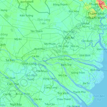
Name: Tien Giang province topographic map, elevation, terrain.
Location: Tien Giang province, Vietnam (10.13995 105.81577 10.58701 106.99337)
Average elevation: 3 m
Minimum elevation: -3 m
Maximum elevation: 38 m
Tiền Giang province has flat terrain with a slope below 1%, and the altitude varying from 0–1.6 metres (0.0–5.2 ft) in comparison with the sea level. The whole province area is in the lower section of Mekong River. Its current terrain surface and land was created by the accumulation of Mekong river silt during the development process of the modern delta in the marine regression period from the mid-Holocene (about 5,000 – 4,500 years to the present), which is also called new silt. In general, because the land surface is new silt which is rich in cat dirt and organic matters; the altitude of topography surface is relatively low. Its force-bearing ability for construction is not high. Therefore, ground leveling need to be done and construction projects need to be reinforced. Deep layers are fairly rich in sand and have better geological characteristics for construction. However, the arrangement of layers is very complex and some layers with bad geological characteristics for construction mingle with good ones. Therefore, it is necessary to carefully study them before the construction of large scale or heavy load, etc. is carried out. The whole region does not have a clear slope direction but there are several zones whose terrain is lower or higher than the general terrain.
Other topographic maps
Click on a map to view its topography, its elevation and its terrain.
Xã Mê Linh
Vietnam > Lâm Đồng Province > Lâm Hà District
Xã Mê Linh, Lâm Hà District, Lâm Đồng Province, Vietnam
Average elevation: 1,157 m
Phu Quoc Island
Phu Quoc Island, Kiên Giang Province, Vietnam
Average elevation: 17 m
Buon Ma Thuot
Buon Ma Thuot, Đắk Lắk Province, 63107, Vietnam
Average elevation: 442 m
Côn Sơn Island
Vietnam > Bà Rịa - Vũng Tàu Province > Con Dao
Côn Sơn Island, Con Dao, Côn Đảo District, Bà Rịa - Vũng Tàu Province, Vietnam
Average elevation: 2 m
Green Island
Vietnam > Bà Rịa - Vũng Tàu Province
Green Island, Bà Rịa - Vũng Tàu Province, Vietnam
Average elevation: 1 m
Măng Đen
Vietnam > Kon Tum province > Kon Plông District
Măng Đen, Kon Plông District, Kon Tum Province, Vietnam
Average elevation: 1,131 m
Tân Lạc District
Tân Lạc District, Hoà Bình province, Vietnam
Average elevation: 416 m
Phường Sông Đà
Vietnam > Điện Biên Province > Mường Lay
Phường Sông Đà, Mường Lay, Điện Biên Province, Vietnam
Average elevation: 603 m
Ninh Bình
Ninh Bình, Ninh Binh province, 08000, Vietnam
Average elevation: 5 m
Thị trấn Bình Phú
Thị trấn Bình Phú, Cai Lậy District, Tien Giang province, Vietnam
Average elevation: 4 m
Thai Nguyen City
Vietnam > Thai Nguyen province
Thai Nguyen City, Thai Nguyen province, 20000, Vietnam
Average elevation: 40 m