
Dong Thap Province topographic map
Interactive map
Click on the map to display elevation.
About this map
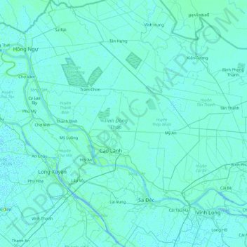
Name: Dong Thap Province topographic map, elevation, terrain.
Location: Dong Thap Province, Vietnam (10.13477 105.18558 10.97332 105.94190)
Average elevation: 3 m
Minimum elevation: -3 m
Maximum elevation: 84 m
The topography of the province is quite flat with a sloping tendency from north to south and west to east, separating it into two large regions: one to the north of the Tiền River, having an area of 250,731 hectares (619,570 acres), in the Đồng Tháp Muoi area; and one to the south of the Tiền River, having an area of 73,074 hectares (180,570 acres), lying between the Tiền River and Hậu River. Đồng Tháp benefits from a large river, channel and spring system, frequently silt-aggraded soil, and a permanently fresh and non-saline water source.
Other topographic maps
Click on a map to view its topography, its elevation and its terrain.
Xã Mê Linh
Vietnam > Lâm Đồng Province > Lâm Hà District
Xã Mê Linh, Lâm Hà District, Lâm Đồng Province, Vietnam
Average elevation: 1,157 m
Phu Quoc Island
Phu Quoc Island, Kiên Giang Province, Vietnam
Average elevation: 17 m
Buon Ma Thuot
Buon Ma Thuot, Đắk Lắk Province, 63107, Vietnam
Average elevation: 442 m
Côn Sơn Island
Vietnam > Bà Rịa - Vũng Tàu Province > Con Dao
Côn Sơn Island, Con Dao, Côn Đảo District, Bà Rịa - Vũng Tàu Province, Vietnam
Average elevation: 2 m
Green Island
Vietnam > Bà Rịa - Vũng Tàu Province
Green Island, Bà Rịa - Vũng Tàu Province, Vietnam
Average elevation: 1 m
Măng Đen
Vietnam > Kon Tum province > Kon Plông District
Măng Đen, Kon Plông District, Kon Tum Province, Vietnam
Average elevation: 1,131 m
Tân Lạc District
Tân Lạc District, Hoà Bình province, Vietnam
Average elevation: 416 m
Phường Sông Đà
Vietnam > Điện Biên Province > Mường Lay
Phường Sông Đà, Mường Lay, Điện Biên Province, Vietnam
Average elevation: 603 m
Ninh Bình
Ninh Bình, Ninh Binh province, 08000, Vietnam
Average elevation: 5 m
Thị trấn Bình Phú
Thị trấn Bình Phú, Cai Lậy District, Tien Giang province, Vietnam
Average elevation: 4 m
Thai Nguyen City
Vietnam > Thai Nguyen province
Thai Nguyen City, Thai Nguyen province, 20000, Vietnam
Average elevation: 40 m