
Quang Binh province topographic map
Interactive map
Click on the map to display elevation.
About this map
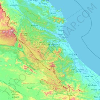
Name: Quang Binh province topographic map, elevation, terrain.
Location: Quang Binh province, Vietnam (16.92137 105.60767 18.13096 107.12337)
Average elevation: 253 m
Minimum elevation: -2 m
Maximum elevation: 1,958 m
Coordinates 16°55’ to 18°05’ North and 105°37’ to 107°00’ East. It borders Hà Tĩnh province on the north with the Ngang mountain pass as the natural frontier, Quảng Trị province to the south, Laos to the west, and faces the Dong Sea to the east. The narrowest part from east (seaside) to west (Laotian border) is just 40 km. The provincial topography is characterized by a general slope, higher in the west and lower in the east, with hilly and mountainous areas accounting for 85% of the total area. The Annamite Range is the natural border between Quảng Bình province and Laos with peaks ranging from 1,000 to 1,500 m, the summit of which is peak Phi Co Pi with the height of 2,017 m. In the east of the province are lower hills and then several narrow plains and river deltas. The seaside sand dunes belt is a natural dam that protects the land from the ocean tides.
Other topographic maps
Click on a map to view its topography, its elevation and its terrain.
Xã Mê Linh
Vietnam > Lâm Đồng Province > Lâm Hà District
Xã Mê Linh, Lâm Hà District, Lâm Đồng Province, Vietnam
Average elevation: 1,157 m
Phu Quoc Island
Phu Quoc Island, Kiên Giang Province, Vietnam
Average elevation: 17 m
Buon Ma Thuot
Buon Ma Thuot, Đắk Lắk Province, 63107, Vietnam
Average elevation: 442 m
Côn Sơn Island
Vietnam > Bà Rịa - Vũng Tàu Province > Con Dao
Côn Sơn Island, Con Dao, Côn Đảo District, Bà Rịa - Vũng Tàu Province, Vietnam
Average elevation: 2 m
Green Island
Vietnam > Bà Rịa - Vũng Tàu Province
Green Island, Bà Rịa - Vũng Tàu Province, Vietnam
Average elevation: 1 m
Măng Đen
Vietnam > Kon Tum province > Kon Plông District
Măng Đen, Kon Plông District, Kon Tum Province, Vietnam
Average elevation: 1,131 m
Tân Lạc District
Tân Lạc District, Hoà Bình province, Vietnam
Average elevation: 416 m
Phường Sông Đà
Vietnam > Điện Biên Province > Mường Lay
Phường Sông Đà, Mường Lay, Điện Biên Province, Vietnam
Average elevation: 603 m
Ninh Bình
Ninh Bình, Ninh Binh province, 08000, Vietnam
Average elevation: 5 m
Thị trấn Bình Phú
Thị trấn Bình Phú, Cai Lậy District, Tien Giang province, Vietnam
Average elevation: 4 m
Thai Nguyen City
Vietnam > Thai Nguyen province
Thai Nguyen City, Thai Nguyen province, 20000, Vietnam
Average elevation: 40 m