
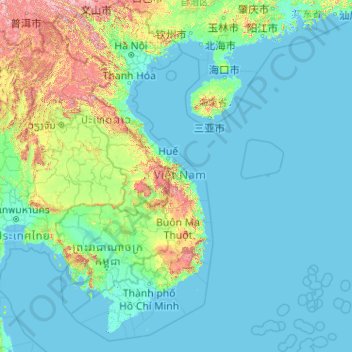
Vietnam topographic map
Interactive map
Click on the map to display elevation.
About this map
Name: Vietnam topographic map, elevation, terrain.
Location: Vietnam (7.69209 102.14386 23.39269 114.85726)
Average elevation: 173 m
Minimum elevation: -3 m
Maximum elevation: 2,808 m
Due to differences in latitude and the marked variety in topographical relief, Vietnam's climate tends to vary considerably for each region. Vietnam is a country located in the tropics, however Northern Vietnam, including Hanoi, is considered a subtropical region by Köppen climate classification and has times to be influenced by cold waves from the Northeast. Cold waves also can influence northern part of Central Vietnam. During the winter or dry season, extending roughly from November to April, the monsoon winds usually blow from the northeast along the Chinese coast and across the Gulf of Tonkin, picking up considerable moisture. The average annual temperature is generally higher in the plains than in the mountains, especially in southern Vietnam compared to the north. Temperatures vary less in the southern plains around Ho Chi Minh City and the Mekong Delta, ranging from between 21 and 35 °C (69.8 and 95.0 °F) over the year. In Hanoi and the surrounding areas of Red River Delta, the temperatures are much lower between 15 and 33 °C (59.0 and 91.4 °F). Seasonal variations in the mountains, plateaus, and the northernmost areas are much more dramatic, with temperatures varying from 3 °C (37.4 °F) in December and January to 37 °C (98.6 °F) in July and August. During winter, snow occasionally falls over the highest peaks of the far northern mountains near the Chinese border. Vietnam receives high rates of precipitation in the form of rainfall with an average amount from 1,500 mm (59 in) to 2,000 mm (79 in) during the monsoon seasons; this often causes flooding, especially in the cities with poor drainage systems. The country is also affected by tropical depressions, tropical storms and typhoons. Vietnam is one of the most vulnerable countries to climate change, with 55% of its population living in low-elevation coastal areas.
Other topographic maps
Click on a map to view its topography, its elevation and its terrain.
Sydney
Sydney, Council of the City of Sydney, New South Wales, Australia
Average elevation: 53 m
Perth
Australia > Western Australia > City of Perth
Perth, City of Perth, Western Australia, 6000, Australia
Average elevation: 26 m
Brisbane
Australia > Queensland > Brisbane
Brisbane, Queensland, 4000, Australia
Average elevation: 45 m
Gold Coast
Australia > Queensland > Gold Coast
Gold Coast, Queensland, 4217, Australia
Average elevation: 42 m
Sydney
Australia > New South Wales > Sydney
Sydney, Council of the City of Sydney, New South Wales, 2000, Australia
Average elevation: 23 m
Saibai Island
Saibai Island, Torres Strait Island Regional, Queensland, Australia
Average elevation: 1 m
Adelaide
Australia > South Australia > Adelaide
Adelaide, Adelaide City Council, South Australia, 5000, Australia
Average elevation: 148 m
Australia
Australia
Average elevation: 35 m
Houston
United States of America > Texas > Houston
Houston, Harris County, Texas, 77002-5902, United States of America
Average elevation: 18 m
Port Macquarie
Port Macquarie, Port Macquarie-Hastings Council, New South Wales, 2444, Australia
Average elevation: 5 m
Newcastle
Australia > New South Wales > Newcastle
Newcastle, Newcastle-Maitland, Newcastle City Council, New South Wales, 2300, Australia
Average elevation: 5 m
Albany
Albany, City Of Albany, Western Australia, 6330, Australia
Average elevation: 30 m
Everett
United States > Washington > Snohomish County
Everett, Snohomish County, Washington, United States
Average elevation: 66 m
Wagga Wagga City Council
Wagga Wagga City Council, New South Wales, Australia
Average elevation: 282 m
Central Coast Council
Central Coast Council, New South Wales, Australia
Average elevation: 103 m
Northern Beaches
Australia > New South Wales > Sydney
Northern Beaches, Sydney, Northern Beaches Council, New South Wales, Australia
Average elevation: 67 m
Orange
Orange, Orange City Council, New South Wales, 2800, Australia
Average elevation: 852 m
Adelaide Hills Council
Adelaide Hills Council, South Australia, Australia
Average elevation: 305 m
Beaverton
United States > Oregon > Washington County
Beaverton, Washington County, Oregon, United States
Average elevation: 106 m
Toowoomba
Toowoomba, Toowoomba Regional, Queensland, 4350, Australia
Average elevation: 458 m
Wollongong
Australia > New South Wales > Wollongong
Wollongong, Wollongong City Council, New South Wales, 2500, Australia
Average elevation: 115 m
New Zealand
New Zealand
Average elevation: 399 m
Mount Gravatt
Mount Gravatt, Greater Brisbane, Queensland, 4122, Australia
Average elevation: 70 m
Bathurst Regional Council
Bathurst Regional Council, New South Wales, 2795, Australia
Average elevation: 845 m
Mandurah
Mandurah, City Of Mandurah, Western Australia, 6201, Australia
Average elevation: 5 m
Greater Brisbane
Greater Brisbane, City of Moreton Bay, Queensland, Australia
Average elevation: 87 m
Grassy Head
Grassy Head, Kempsey Shire Council, New South Wales, 2441, Australia
Average elevation: 44 m
North Sydney
Australia > New South Wales > Sydney
North Sydney, Lower North Shore, Sydney, North Sydney Council, New South Wales, 2060, Australia
Average elevation: 50 m
Lismore City Council
Lismore City Council, New South Wales, 2480, Australia
Average elevation: 83 m
Hunter Valley
Australia > New South Wales > Cessnock
Hunter Valley, Cessnock, Cessnock City Council, New South Wales, Australia
Average elevation: 70 m
Grafton
Grafton, Clarence Valley Council, New South Wales, Australia
Average elevation: 36 m
Sunshine Coast
Australia > Queensland > Sunshine Coast Regional
Sunshine Coast, Sunshine Coast Regional, Queensland, Australia
Average elevation: 109 m
Mosman
Australia > New South Wales > Sydney
Mosman, Lower North Shore, Sydney, Mosman Municipal Council, New South Wales, 2088, Australia
Average elevation: 28 m
Redwood City
United States > California > San Mateo County
Redwood City, San Mateo County, California, United States
Average elevation: 32 m
Macleay Island
Macleay Island, Greater Brisbane, Redland City, Queensland, 4184, Australia
Average elevation: 3 m