
Make a donation
Gear up for your next adventure:
As an Amazon Associate, this site earns from qualifying purchases at no extra cost to you.
Great Dividing Range topographic map
Click on the map to display elevation.
Make a donation
Gear up for your next adventure:
As an Amazon Associate, this site earns from qualifying purchases at no extra cost to you.
Great Dividing Range
The Great Dividing Range, also known as the East Australian Cordillera or the Eastern Highlands, is a cordillera system in eastern Australia consisting of an expansive collection of mountain ranges, plateaus and rolling hills, that runs roughly parallel to the east coast of Australia and forms the fifth-longest land-based mountain chain in the world, and the longest entirely within a single country. It is mainland Australia's most substantial topographic feature and serves as the definitive watershed for the river systems in eastern Australia, hence the name.
Make a donation
Gear up for your next adventure:
As an Amazon Associate, this site earns from qualifying purchases at no extra cost to you.
About this map
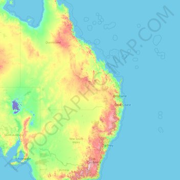
Name: Great Dividing Range topographic map, elevation, terrain.
Location: Great Dividing Range, Australia (-37.82225 142.46375 -13.66768 152.52520)
Average elevation: 117 m
Minimum elevation: -16 m
Maximum elevation: 1,959 m
Australia trails, hiking, mountain biking, running and outdoor activities
Make a donation
Gear up for your next adventure:
As an Amazon Associate, this site earns from qualifying purchases at no extra cost to you.
Other topographic maps
Click on a map to view its topography, its elevation and its terrain.
Sydney
Sydney's topography is characterized by a diverse landscape that seamlessly blends coastal features with inland plateaus. The city is divided into two primary regions: the relatively flat Cumberland Plain to the south and west of Sydney Harbour, and the elevated Hornsby Plateau to the north. The Cumberland…
Average elevation: 53 m
City of Melbourne
Melbourne's topography is characterized by a diverse landscape that transitions from flat coastal plains to rolling hills and mountainous regions. The city is situated at the northern end of Port Phillip Bay, where the terrain is predominantly flat, facilitating urban development. As one moves eastward, the…
Average elevation: 18 m
Victoria
Victoria, Australia, exhibits a remarkably varied topography shaped by the Great Dividing Range, which forms a west-to-east spine across the state. In the northeast, the Victorian Alps rise to the state’s highest point, Mount Bogong at 1,986 meters, amid deep valleys and snow-capped ridges, while westward,…
Average elevation: 179 m
Make a donation
Gear up for your next adventure:
As an Amazon Associate, this site earns from qualifying purchases at no extra cost to you.
New South Wales
New South Wales (NSW), located on Australia's eastern seaboard, boasts a diverse topography that significantly influences its landscapes and ecosystems. The state's eastern edge is dominated by a narrow coastal plain, featuring regions such as the Illawarra and Shoalhaven near Nowra, characterized by rolling…
Average elevation: 154 m
Queensland
Queensland's topography is characterized by a diverse landscape that includes coastal plains, mountain ranges, plateaus, and expansive inland areas. The Great Dividing Range runs parallel to the state's eastern coast, forming a series of mountain ranges, plateaus, and upland areas. This range influences the…
Average elevation: 122 m
Perth
Perth, the capital of Western Australia, is situated on the Swan Coastal Plain, a flat expanse of sandy soil nestled between the Indian Ocean to the west and the Darling Scarp to the east. The Darling Scarp, also known as the Darling Range, is a low escarpment that extends north–south, marking a distinct…
Average elevation: 26 m
Canberra
The area chosen for the capital had been inhabited by Indigenous Australians for up to 21,000 years, with the principal group being the Ngunnawal people. European settlement commenced in the first half of the 19th century, as evidenced by surviving landmarks such as St John's Anglican Church and Blundells…
Average elevation: 638 m
Make a donation
Gear up for your next adventure:
As an Amazon Associate, this site earns from qualifying purchases at no extra cost to you.
Adelaide
Australia > South Australia > Adelaide
Adelaide is north of the Fleurieu Peninsula, on the Adelaide Plains between the Gulf St Vincent and the low-lying Mount Lofty Ranges. The city stretches 20 km (12 mi) from the coast to the foothills, and 90 km (56 mi) from Gawler at its northern extent to Sellicks Beach in the south. According to the Regional…
Average elevation: 148 m
New South Wales
New South Wales (NSW), located on Australia's eastern seaboard, boasts a diverse topography that significantly influences its landscapes and ecosystems. The state's eastern edge is dominated by a narrow coastal plain, featuring regions such as the Illawarra and Shoalhaven near Nowra, characterized by rolling…
Average elevation: 154 m
Melbourne
Melbourne is also prone to isolated convective showers forming when a cold pool crosses the state, especially if there is considerable daytime heating. These showers are often heavy and can include hail, squalls, and significant drops in temperature, but they often pass through very quickly with a rapid…
Average elevation: 185 m
Make a donation
Gear up for your next adventure:
As an Amazon Associate, this site earns from qualifying purchases at no extra cost to you.
Tasmania
The most mountainous region is the Central Highlands area, which covers most of the central western parts of the state. The Midlands located in the central east, is fairly flat, and is predominantly used for agriculture, although farming activity is scattered throughout the state. Tasmania's tallest mountain…
Average elevation: 220 m
Western Australia
Because the only mountain-building since then has been of the Stirling Range with the rifting from Antarctica, the land is extremely eroded and ancient, with no part of the state above 1,245 metres (4,085 ft) AHD (at Mount Meharry in the Hamersley Range of the Pilbara region). Most of the state is a low…
Average elevation: 194 m
Make a donation
Gear up for your next adventure:
As an Amazon Associate, this site earns from qualifying purchases at no extra cost to you.
Melbourne
Melbourne is also prone to isolated convective showers forming when a cold pool crosses the state, especially if there is considerable daytime heating. These showers are often heavy and can include hail, squalls, and significant drops in temperature, but they often pass through very quickly with a rapid…
Average elevation: 49 m
Ballarat
Ballarat has a moderate oceanic climate (Köppen climate classification Cfb) with four distinct seasons. Its elevation, ranging between 400 and 630 metres (1,310 and 2,070 feet) above sea level, causes its mean monthly temperatures to tend to be on average 3 to 5 °C (5 to 9 °F) below those of Melbourne,…
Average elevation: 470 m
Sunshine Coast
Australia > Queensland > Sunshine Coast Regional
The Sunshine Coast in Queensland, Australia, showcases a diverse topography that harmoniously blends coastal plains with rugged hinterlands. Along its eastern edge, the region features expansive sandy beaches and coastal dunes that transition smoothly into fertile lowlands. Inland, the terrain becomes more…
Average elevation: 109 m
Make a donation
Gear up for your next adventure:
As an Amazon Associate, this site earns from qualifying purchases at no extra cost to you.
Melbourne
Melbourne is also prone to isolated convective showers forming when a cold pool crosses the state, especially if there is considerable daytime heating. These showers are often heavy and can include hail, squalls, and significant drops in temperature, but they often pass through very quickly with a rapid…
Average elevation: 185 m
Make a donation
Gear up for your next adventure:
As an Amazon Associate, this site earns from qualifying purchases at no extra cost to you.
Mount Banks
Mount Banks, otherwise known as Mount King George, is a mountain within the Explorers Range of the Blue Mountains Range that is a spur off the Great Dividing Range, is located within the Blue Mountains National Park, approximately 100 kilometres (62 mi) west of Sydney in New South Wales, Australia. Mount Banks…
Average elevation: 745 m
City of Brisbane
Brisbane's topography is characterized by a series of hills and ranges that define its landscape. The city is situated on a low-lying floodplain, with the Brisbane River meandering through its heart, creating a winding course with many steep curves from the southwest to its mouth at Moreton Bay in the east.…
Average elevation: 71 m
Make a donation
Gear up for your next adventure:
As an Amazon Associate, this site earns from qualifying purchases at no extra cost to you.
Make a donation
Gear up for your next adventure:
As an Amazon Associate, this site earns from qualifying purchases at no extra cost to you.
Mount Kosciuszko
Mount Kosciuszko is the highest summit in mainland Australia. Until 1977 it was possible to drive from Charlotte Pass to within a few metres of the summit, but in 1977 the road was closed to public motor vehicle access due to environmental concerns. The road is open from Charlotte Pass for walkers and cyclists…
Average elevation: 2,035 m
Make a donation
Gear up for your next adventure:
As an Amazon Associate, this site earns from qualifying purchases at no extra cost to you.
Make a donation
Gear up for your next adventure:
As an Amazon Associate, this site earns from qualifying purchases at no extra cost to you.
Make a donation
Gear up for your next adventure:
As an Amazon Associate, this site earns from qualifying purchases at no extra cost to you.
Make a donation
Gear up for your next adventure:
As an Amazon Associate, this site earns from qualifying purchases at no extra cost to you.
Cairns
South of Smithfield and inland from the Northern Beaches along the edge of the Barron River flood plain are the suburbs of Caravonica, Kamerunga, Freshwater, and Stratford. This area is sometimes referred to as Freshwater Valley, though it is actually the lower part of Redlynch Valley; further up the valley…
Average elevation: 176 m
Make a donation
Gear up for your next adventure:
As an Amazon Associate, this site earns from qualifying purchases at no extra cost to you.
Lama Lama National Park (Cape York Peninsula Aboriginal Land)
Average elevation: 86 m
Make a donation
Gear up for your next adventure:
As an Amazon Associate, this site earns from qualifying purchases at no extra cost to you.
Make a donation
Gear up for your next adventure:
As an Amazon Associate, this site earns from qualifying purchases at no extra cost to you.
Sunshine Coast Regional
The Sunshine Coast Regional area in Queensland, Australia, features a diverse topography that ranges from coastal plains to rugged hinterlands. Along the coastline, the terrain is predominantly flat, with average elevations around 20 meters (66 feet) above sea level. Inland, the landscape transitions to…
Average elevation: 56 m
Make a donation
Gear up for your next adventure:
As an Amazon Associate, this site earns from qualifying purchases at no extra cost to you.
Blackheath
Blackheath (postcode: 2785) is an Australian town located near the highest point of the Blue Mountains, between Katoomba and Mount Victoria in New South Wales. The town's altitude is about 1,065 metres (3,494 ft) AHD and it is located about 120 kilometres (75 mi) west north-west of Sydney, 11 kilometres…
Average elevation: 893 m
Goulburn
Owing to its elevation, Goulburn has an oceanic climate (Cfb) with warm summers and cool winters; with a high diurnal range. Its climate is variable much of the year, though generally dry with maximum temperatures ranging from 11.8 °C (53.2 °F) in July to 28.3 °C (82.9 °F) in January. Rainfall is…
Average elevation: 666 m
Make a donation
Gear up for your next adventure:
As an Amazon Associate, this site earns from qualifying purchases at no extra cost to you.
Toowoomba
The city occupies the edge of the range and the low ridges behind it. Two valleys run north from the southern boundary, each arising from springs either side of Middle Ridge near Spring Street at an altitude of around 680 m. These waterways, East Creek and West Creek, flow together just north of the CBD to…
Average elevation: 458 m
Make a donation
Gear up for your next adventure:
As an Amazon Associate, this site earns from qualifying purchases at no extra cost to you.
Make a donation
Gear up for your next adventure:
As an Amazon Associate, this site earns from qualifying purchases at no extra cost to you.
Tolmie
Due to its latitude and elevation, Tolmie is frequently affected by snow and chilling rains throughout much of the year. Climate data are sourced from the old Rubicon S.E.C. Sawmill at an elevation of 838 metres (2,749 ft). Tolmie is one of the coldest localities by mean maximum temperature in mainland…
Average elevation: 692 m
Make a donation
Gear up for your next adventure:
As an Amazon Associate, this site earns from qualifying purchases at no extra cost to you.
Make a donation
Gear up for your next adventure:
As an Amazon Associate, this site earns from qualifying purchases at no extra cost to you.
Make a donation
Gear up for your next adventure:
As an Amazon Associate, this site earns from qualifying purchases at no extra cost to you.
Borroloola
The Borroloola Airport has a 1,149-metre long runway at an elevation of 55 feet (16.8 metres). The airport can be very busy during the day and the occasional Careflight services the town during the night. One single-engine Cessna 210 aircraft from Katherine Aviation is based at the airport permanently. It…
Average elevation: 21 m
Make a donation
Gear up for your next adventure:
As an Amazon Associate, this site earns from qualifying purchases at no extra cost to you.
Make a donation
Gear up for your next adventure:
As an Amazon Associate, this site earns from qualifying purchases at no extra cost to you.
Make a donation
Gear up for your next adventure:
As an Amazon Associate, this site earns from qualifying purchases at no extra cost to you.