
Ammassalik Island topographic map
Interactive map
Click on the map to display elevation.
About this map
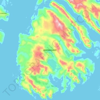
Name: Ammassalik Island topographic map, elevation, terrain.
Location: Ammassalik Island, Sermersooq, 3913, Greenland (65.56730 -37.95031 65.90414 -37.24271)
Average elevation: 201 m
Minimum elevation: -4 m
Maximum elevation: 1,298 m
Other topographic maps
Click on a map to view its topography, its elevation and its terrain.
Geographical Society Island
Geographical Society Island, Sermersooq, Greenland
Average elevation: 178 m
Traill-iup Immikkeertivi
Traill-iup Immikkeertivi, Sermersooq, Greenland
Average elevation: 0 m