
Presidio County topographic map
Interactive map
Click on the map to display elevation.
About this map
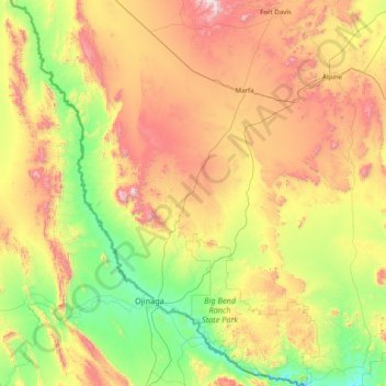
Name: Presidio County topographic map, elevation, terrain.
Location: Presidio County, Texas, United States (29.25837 -104.98075 30.62922 -103.79246)
Average elevation: 1,255 m
Minimum elevation: 716 m
Maximum elevation: 2,348 m
Geographically, Presidio County comprises 3,857 square miles (9,990 km2) of contrasting topography, geology, and vegetation. In the north and west, clay and sandy loam cover the rolling plains known as the Marfa Plateau and the Highland Country, providing good ranges of grama grasses for the widely acclaimed Highland Herefords. In the central, far western, and southeastern areas of the county, some of the highest mountain ranges in Texas are found. These peaks are formed of volcanic rock and covered with loose surface rubble. They support desert shrubs and cacti and dominate a landscape of rugged canyons and numerous springs. The spring-fed Capote Falls, with a drop of 175 feet (53 m), the highest in Texas, is located in western Presidio County. In the southern and western parts of the county, the volcanic cliffs of the Candelaria Rimrock (also called the Sierra Vieja) rise perpendicular and run parallel to the river, separating the highland prairies from the desert floor hundreds of feet below them. The gravel pediment, which allows only the growth of desert shrubs and cacti, extends from the Rimrock to the flood plain of the river. Along the river, irrigation allows the farming of vegetables, grains, and cotton. No permanent streams exist in the county, although many arroyos become raging torrents during heavy rainfalls. Major ones are Alamito Creek, Cibolo Creek, Capote Creek, and Pinto Canyon. San Esteban Dam was built across Alamito Creek and on the site of a historic spring-fed tinaja in 1911 as an irrigation and land-promotion project. Altitudes in the county vary from 2,518 to 7,728 feet (767 to 2,355 m) above sea level. Temperatures, moderated by the mountains, vary from 33 °F (1 °C) in January to 100 °F (38 °C) in July. Average rainfall is 12 inches (300 mm) per year, mainly in June, July, and August. The growing season extends for 238 days. Natural resources under production in 1982 were perlite, crushed rhyolite, sand, and gravel. Silver mining contributed greatly to the economy of the county from the 1880s to the 1940s. Presidio County has no oil or gas production.
Other topographic maps
Click on a map to view its topography, its elevation and its terrain.
Electra
United States > Texas > Wichita County
Electra, Wichita County, Texas, United States
Average elevation: 362 m
Angus
United States > Texas > Navarro County
Angus, Navarro County, Texas, United States
Average elevation: 119 m
Alum
United States > Texas > Wilson County
Alum, Wilson County, Texas, United States
Average elevation: 152 m
Borger
United States > Texas > Hutchinson County
Borger, Hutchinson County, Texas, 79007, United States
Average elevation: 929 m
Mesquite
United States > Texas > Dallas County
Mesquite, Dallas County, Texas, United States
Average elevation: 142 m
San Antonio
United States > Texas > Bexar County
San Antonio, Bexar County, Texas, United States
Average elevation: 247 m
Lake Whitney State Park
United States > Texas > Hill County
Lake Whitney State Park, Hill County, Texas, United States
Average elevation: 165 m
McLean
United States > Texas > Gray County
McLean, Gray County, Texas, 79057, United States
Average elevation: 873 m
Midlothian
United States > Texas > Ellis County
Midlothian, Ellis County, Texas, 76065, United States
Average elevation: 212 m
Frisco
United States > Texas > Collin County
Frisco, Collin County, Texas, United States
Average elevation: 201 m
Canton
United States > Texas > Van Zandt County
Canton, Van Zandt County, Texas, 75103, United States
Average elevation: 159 m
South Lake
United States > Texas > Hill County
South Lake, Hill County, Texas, United States
Average elevation: 189 m
Allen
United States > Texas > Collin County
Allen, Collin County, Texas, United States
Average elevation: 200 m
Converse
United States > Texas > Bexar County
Converse, Bexar County, Texas, 78109, United States
Average elevation: 223 m
Duke
United States > Texas > Fort Bend County > Arcola
Duke, Arcola, Fort Bend County, Texas, 77545, United States
Average elevation: 20 m
Plano
United States > Texas > Collin County
Plano, Collin County, Texas, United States
Average elevation: 196 m
Soil Conservation Service Site 12 Dam
United States > Texas > Williamson County > Type
Soil Conservation Service Site 12 Dam, Type, Williamson County, Texas, United States
Average elevation: 173 m
El Paso
United States > Texas > El Paso County
El Paso, El Paso County, Texas, United States
Average elevation: 1,237 m
Elsa
United States > Texas > Hidalgo County
Elsa, Hidalgo County, Texas, 78543, United States
Average elevation: 22 m
Bayview
United States > Texas > Cameron County
Bayview, Cameron County, Texas, United States
Average elevation: 7 m
Willow Grove
United States > Texas > McLennan County
Willow Grove, McLennan County, Texas, 76702, United States
Average elevation: 169 m
Moran
United States > Texas > Shackelford County
Moran, Shackelford County, Texas, United States
Average elevation: 411 m
Sun Valley
United States > Texas > Lamar County
Sun Valley, Lamar County, Texas, United States
Average elevation: 166 m
Cleveland
United States > Texas > Liberty County
Cleveland, Liberty County, Texas, 77327, United States
Average elevation: 47 m
Lubbock
United States > Texas > Lubbock County
Lubbock, Lubbock County, Texas, United States
Average elevation: 983 m
Seymour
United States > Texas > Baylor County
Seymour, Baylor County, Texas, 76380, United States
Average elevation: 401 m
Crystal City
United States > Texas > Zavala County
Crystal City, Zavala County, Texas, 78839, United States
Average elevation: 174 m
Carrizo Springs
United States > Texas > Dimmit County
Carrizo Springs, Dimmit County, Texas, 78834, United States
Average elevation: 185 m
Horseshoe Bay
United States > Texas > Llano County
Horseshoe Bay, Llano County, Texas, 78657, United States
Average elevation: 290 m
Omen
United States > Texas > Smith County
Omen, Smith County, Texas, 75750, United States
Average elevation: 135 m
Signal Hill
United States > Texas > Williamson County
Signal Hill, Williamson County, Texas, United States
Average elevation: 291 m
Dublin
United States > Texas > Erath County
Dublin, Erath County, Texas, 76446, United States
Average elevation: 451 m
Mayhill
United States > Texas > Denton County > Denton
Mayhill, Denton, Denton County, Texas, 76208, United States
Average elevation: 183 m
Canturbury Trails Park
United States > Texas > Travis County > Austin
Canturbury Trails Park, Austin, Travis County, Texas, United States
Average elevation: 210 m
Carpenters Bluff
United States > Texas > Grayson County
Carpenters Bluff, Grayson County, Texas, United States
Average elevation: 165 m
Lake Cooper
United States > Texas > Archer County
Lake Cooper, Archer County, Texas, United States
Average elevation: 357 m