
Malacca topographic map
Interactive map
Click on the map to display elevation.
About this map
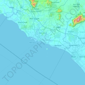
Name: Malacca topographic map, elevation, terrain.
Location: Malacca, Malaysia (1.83953 101.83280 2.49905 102.59438)
Average elevation: 26 m
Minimum elevation: -1 m
Maximum elevation: 1,186 m
The state of Malacca covers an area of 1,664 km2 (642 sq mi). It sits upon the southwestern coast of the Malay Peninsula opposite Sumatra, with the state of Negeri Sembilan to the north and west and Johor to the east. Malacca is situated roughly two-thirds of the way down the west coast, 148 km (92 mi) south of Kuala Lumpur and commands a central position on the Straits of Malacca. With the exception of some of its small hills, Malacca is generally a lowland area with average elevation below 50 meters above sea level.
Other topographic maps
Click on a map to view its topography, its elevation and its terrain.
South-West
Malaysia > Penang > George Town
South-West, George Town, Penang, Malaysia
Average elevation: 55 m
Kuala Penyu
Malaysia > Sabah > Kuala Penyu
Kuala Penyu, Interior Division, Sabah, 89740, Malaysia
Average elevation: 8 m
Timah Tasoh Reservoir
Timah Tasoh Reservoir, Perlis, Malaysia
Average elevation: 32 m
Sungai Besar
Sungai Besar, Sabak Bernam, Selangor, 45300, Malaysia
Average elevation: 3 m
Rantau
Rantau, Seremban, Negeri Sembilan, 71200, Malaysia
Average elevation: 38 m
Klang Municipal Council
Klang Municipal Council, Klang, Selangor, Malaysia
Average elevation: 12 m
Kampung Istana
Malaysia > Johor > Batu Pahat
Kampung Istana, Batu Pahat, Johor, 83000, Malaysia
Average elevation: 43 m
Federal Territory of Kuala Lumpur
Federal Territory of Kuala Lumpur, Malaysia
Average elevation: 119 m
Kampung Periuk
Kampung Periuk, Kampong Bharu, Kuala Lumpur, 50300, Malaysia
Average elevation: 47 m
Gelang Patah
Malaysia > Johor > Iskandar Puteri
Gelang Patah, Iskandar Puteri, Johor Bahru, Iskandar Malaysia, Johor, 81550, Malaysia
Average elevation: 17 m
Selayang Municipal Council
Selayang Municipal Council, Gombak, Selangor, Malaysia
Average elevation: 236 m
Sungai Baleh
Malaysia > Sarawak > Nanga Gaat
Sungai Baleh, Nanga Gaat, Sarawak, Malaysia
Average elevation: 188 m
Johor Bahru
Johor Bahru, Iskandar Malaysia, Johor, 80350, Malaysia
Average elevation: 28 m
Sri Aman Division
Malaysia > Sarawak > Simanggang
Sri Aman Division, Simanggang, Sarawak, 95000, Malaysia
Average elevation: 84 m
Kuala Lumpur International Airport
Kuala Lumpur International Airport, Selangor, 64000, Malaysia
Average elevation: 13 m
Batu Dam
Malaysia > Selangor > Selayang Municipal Council
Batu Dam, Taman Jasa Utama, Selayang Municipal Council, Gombak, Selangor, Malaysia
Average elevation: 141 m
Ampang Jaya Municipal Council
Ampang Jaya Municipal Council, Hulu Langat, Selangor, 55300, Malaysia
Average elevation: 167 m
Kajang Municipal Council
Kajang Municipal Council, Hulu Langat, Selangor, Malaysia
Average elevation: 198 m
Iskandar Puteri
Iskandar Puteri, Johor Bahru, Iskandar Malaysia, Johor, Malaysia
Average elevation: 26 m
Manek Urai
Malaysia > Kelantan > Manek Urai
Manek Urai, Kuala Krai, Kelantan, Malaysia
Average elevation: 62 m
Kampung Patau-Patau II (Water Village)
Kampung Patau-Patau II (Water Village), Victoria, Labuan, 87009, Malaysia
Average elevation: 7 m