
Diamond Head topographic map
Interactive map
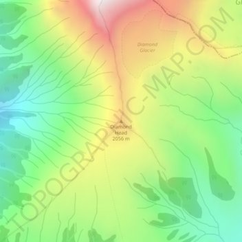
Click on the map to display elevation.
About this map
Name: Diamond Head topographic map, elevation, terrain.
Average elevation: 1,733 m
Minimum elevation: 1,171 m
Maximum elevation: 2,528 m
Other topographic maps
Click on a map to view its topography, its elevation and its terrain.
Watson Bay
Canada > British Columbia > Regional District of Kitimat-Stikine > Area C (Butedale/Kitlope/Kitsumkalum)
Average elevation: 138 m
Ball Creek
Canada > British Columbia > Regional District of Kitimat-Stikine > Area D (Iskut/Big Raven)
Average elevation: 1,231 m
Southern Gulf Islands Electoral Area
Canada > British Columbia > Capital Regional District
Average elevation: 35 m
Poplar Creek
Canada > British Columbia > Regional District of Central Kootenay > Area D (Lardeau Valley/Duncan Lake)
Average elevation: 1,732 m
Kitsilano
Canada > British Columbia > Metro Vancouver Regional District > Vancouver
Average elevation: 24 m
Valemount
Canada > British Columbia > Regional District of Fraser-Fort George
Average elevation: 795 m
Area B (Lazo North)
Canada > British Columbia > Comox Valley Regional District
Average elevation: 11 m
Area A (Nass Valley/Bell Irving)
Canada > British Columbia > Regional District of Kitimat-Stikine
Average elevation: 957 m
Dent Island
Canada > British Columbia > Strathcona Regional District > Area B (Discovery Islands/Mainland Inlets)
Average elevation: 52 m
Little Big Horn
Canada > British Columbia > Squamish-Lillooet Regional District > Area A (Upper Bridge River Valley)
Average elevation: 1,986 m
Stanley Park
Canada > British Columbia > Metro Vancouver Regional District > Vancouver
Average elevation: 14 m
MacArther Island
Canada > British Columbia > Regional District of Fraser-Fort George > Area G (Crooked River/Parsnip)
Average elevation: 713 m
Upper Sumas Pioneer Park
Canada > British Columbia > Fraser Valley Regional District > Abbotsford
Average elevation: 7 m
Yoho National Park
Canada > British Columbia > Columbia-Shuswap Regional District
The weather in the park is localized and changeable. Located on the western side of the continental divide, it receives more precipitation than areas east of the divide. Precipitation in the park increases with elevation. In winter, average temperatures are between 5 and −15 °C (41.0 and 5.0 °F) from the…
Average elevation: 1,934 m
Area F (Kokanee Range)
Canada > British Columbia > Regional District of Central Kootenay
Average elevation: 1,463 m
Buchan Inlet
Canada > British Columbia > North Coast Regional District > Area C (South Skeena)
Average elevation: 39 m
Area B (Cayoosh/Pavilion)
Canada > British Columbia > Squamish-Lillooet Regional District
Average elevation: 1,483 m
Area D (Oyster Bay/Buttle Lake)
Canada > British Columbia > Strathcona Regional District
Average elevation: 723 m
Blackcomb Glacier Provincial Park
Canada > British Columbia > Squamish-Lillooet Regional District > Whistler Resort Municipality
Average elevation: 2,073 m
Area A (Kicking Horse/Kinbasket Lake)
Canada > British Columbia > Columbia-Shuswap Regional District
Average elevation: 1,846 m
Boyd Creek
Canada > British Columbia > Columbia-Shuswap Regional District > Area B (Shelter Bay/Mica Creek)
Average elevation: 1,570 m
Croker Island
Canada > British Columbia > Metro Vancouver Regional District > Electoral Area A
Average elevation: 112 m
Mission
Canada > British Columbia > Fraser Valley Regional District
The western part of the district, the Stave Valley, is largely rural and forested but its watercourse is home to what was the largest hydroelectric project in British Columbia until the Bridge River Power Project opened in 1961. It was built by the British Columbia Electric Railway (BCER) to provide power to…
Average elevation: 345 m
Surf Islands
Canada > British Columbia > Central Coast Regional District > Area A (Ocean Falls/Outer Coast)
Average elevation: 3 m
Darby Channel
Canada > British Columbia > Central Coast Regional District > Area A (Ocean Falls/Outer Coast)
Average elevation: 113 m
Fingal Island
Canada > British Columbia > Central Coast Regional District > Area A (Ocean Falls/Outer Coast)
Average elevation: 0 m
Penticton
Canada > British Columbia > Regional District of Okanagan-Similkameen
Penticton is located at the geographical coordinates of 49°29′28″N 119°35′19″W / 49.49111°N 119.58861°W / 49.49111; -119.58861 (Penticton) and covers an area of 42.10 km2 (16.25 sq mi), with a maximum north–south distance of 7 km (4.3 mi) wide between the Okanagan Lake to the north…
Average elevation: 702 m
Queens Park
Canada > British Columbia > Metro Vancouver Regional District > New Westminster
Average elevation: 57 m
Frazer Island
Canada > British Columbia > Capital Regional District > Juan de Fuca Electoral Area
Average elevation: 14 m
Gambier Island
Canada > British Columbia > Sunshine Coast Regional District > Area F (West Howe Sound)
Average elevation: 130 m
Vancouver Island
Canada > British Columbia > Area D (Oyster Bay/Buttle Lake)
The rain shadow effect of the island's mountains, as well as the mountains of Washington's Olympic Peninsula, creates wide variation in precipitation. The west coast is considerably wetter than the east coast. Average annual precipitation ranges from 6,650 mm (262 in) at Hucuktlis Lake on the west coast…
Average elevation: 411 m
Juan de Fuca Electoral Area
Canada > British Columbia > Juan de Fuca Electoral Area
Average elevation: 255 m
University Endowment Lands
Canada > British Columbia > University Endowment Lands
Average elevation: 33 m
District of North Vancouver
Canada > British Columbia > Metro Vancouver Regional District
Average elevation: 358 m
Lillian Russell Creek
Canada > British Columbia > Area B (Discovery Islands/Mainland Inlets)
Average elevation: 168 m
Sanctuary Lake
Canada > British Columbia > Area M (Beautiful Nicola Valley - North) > Douglas Lake
Average elevation: 841 m
Emerald Lake
Canada > British Columbia > Columbia-Shuswap Regional District > Area A (Kicking Horse/Kinbasket Lake)
The lake is enclosed by mountains of the President Range, as well as Mount Burgess and Wapta Mountain. This basin traps storms, causing frequent rain in summer and heavy snowfalls in winter. This influx of moisture works with the lake's low elevation to produce a unique selection of flora. Trees found here are…
Average elevation: 1,413 m
Chetwynd
Canada > British Columbia > Chetwynd
Carved out of an ancient floodplain, the small terrace upon which Chetwynd is situated lies in the northern foothills of the Rocky Mountains. Once used as a grazing spot by nomadic Aboriginals, the terrace was farmed by settlers until it was developed into a town. Two types of soil—namely, the Widmark and…
Average elevation: 910 m
Metro Vancouver Regional District
Canada > British Columbia > Metro Vancouver Regional District
Average elevation: 343 m
Invermere
Canada > British Columbia > Regional District of East Kootenay > Invermere
Average elevation: 876 m
Tennent Creek
Canada > British Columbia > Strathcona Regional District > Area D (Oyster Bay/Buttle Lake)
Average elevation: 1,005 m
Clarence Lake
Canada > British Columbia > Thompson-Nicola Regional District > Area P (Rivers and the Peaks)
Average elevation: 1,024 m
Area C (Old Fort/Charlie Lake)
Canada > British Columbia > Peace River Regional District > Area C (Old Fort/Charlie Lake)
Average elevation: 669 m
High Canada Place Park
Canada > British Columbia > Thompson-Nicola Regional District > Kamloops
Average elevation: 678 m
Area A (Hudson Bay Mountain)
Canada > British Columbia > Regional District of Bulkley-Nechako > Area A (Hudson Bay Mountain)
Average elevation: 1,108 m
Area C (Arrowsmith-Benson)
Canada > British Columbia > Regional District of Nanaimo > Area C (Arrowsmith-Benson)
Average elevation: 429 m