
Niğde topographic map
Interactive map
Click on the map to display elevation.
About this map
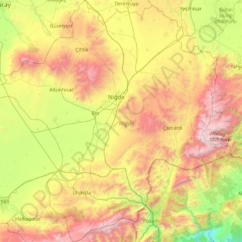
Name: Niğde topographic map, elevation, terrain.
Location: Niğde, Central Anatolia Region, Turkey (37.33142 33.97554 38.38865 35.31111)
Average elevation: 1,508 m
Minimum elevation: 254 m
Maximum elevation: 3,740 m
Niğde (Ancient Greek: Νίγδη/Hittite: Nahita, Naxita) is a town and the capital of Niğde Province in the Central Anatolia region of Turkey at an elevation of 1,299 m. In 2019 the population was 362.861
Other topographic maps
Click on a map to view its topography, its elevation and its terrain.
Ballık
Ballık, Altınyayla, Burdur, Mediterranean Region, Turkey
Average elevation: 1,528 m
Bezirhane Mahallesi
Bezirhane Mahallesi, Gölbaşı, Ankara, Central Anatolia Region, Turkey
Average elevation: 1,158 m
Bıçakcılar
Bıçakcılar, Yusufeli, Artvin, Black Sea Region, Turkey
Average elevation: 1,833 m
Eskisehir
Eskisehir, Odunpazarı, Eskişehir, Central Anatolia Region, 26120, Turkey
Average elevation: 949 m
İshakçelebi
İshakçelebi, Saruhanlı, Manisa, Aegean Region, Turkey
Average elevation: 55 m
Akşemsettin Mahallesi
Akşemsettin Mahallesi, Eyüpsultan, Istanbul, Marmara Region, 34070, Turkey
Average elevation: 62 m
Camuzcu Mahallesi
Camuzcu Mahallesi, Seyhan, Adana, Mediterranean Region, Turkey
Average elevation: 13 m