
Make a donation
Gear up for your next adventure:
As an Amazon Associate, this site earns from qualifying purchases at no extra cost to you.
Şiran topographic map
Click on the map to display elevation.
Make a donation
Gear up for your next adventure:
As an Amazon Associate, this site earns from qualifying purchases at no extra cost to you.
Şiran
Şiran (Pontic: Cheriana) is a town in Gümüşhane Province in the Black Sea region of Turkey. It is the seat of Şiran District. Its population is 11,539 (2022). It is one of the points of passage between Eastern Anatolia and Black Sea regions of Turkey, in the sense that the western road departing from Erzincan towards the Zigana Pass (the key pass between the two geographies) has its last urban stop in Şiran. The town lies at an elevation of 1,457 m (4,780 ft)
Make a donation
Gear up for your next adventure:
As an Amazon Associate, this site earns from qualifying purchases at no extra cost to you.
About this map
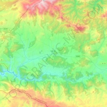
Name: Şiran topographic map, elevation, terrain.
Location: Şiran, Gümüşhane, Black Sea Region, Turkey (39.99948 38.87310 40.36109 39.33895)
Average elevation: 1,773 m
Minimum elevation: 1,121 m
Maximum elevation: 3,244 m
Make a donation
Gear up for your next adventure:
As an Amazon Associate, this site earns from qualifying purchases at no extra cost to you.
Other topographic maps
Click on a map to view its topography, its elevation and its terrain.
Gaziantep
The plan introduced several important changes to the city's transportation network. One of the most important was the addition of a rail line to connect Gaziantep to the national rail system. Up to now, Turkish railway construction had ignored Gaziantep (partly because of its mountainous surroundings); a…
Average elevation: 880 m
Make a donation
Gear up for your next adventure:
As an Amazon Associate, this site earns from qualifying purchases at no extra cost to you.
Make a donation
Gear up for your next adventure:
As an Amazon Associate, this site earns from qualifying purchases at no extra cost to you.
Make a donation
Gear up for your next adventure:
As an Amazon Associate, this site earns from qualifying purchases at no extra cost to you.
Make a donation
Gear up for your next adventure:
As an Amazon Associate, this site earns from qualifying purchases at no extra cost to you.
Eskisehir
Eskişehir has a cold semi-arid climate (BSk) under the Köppen climate classification, and a temperate continental climate (Dc) under the Trewartha climate classification. The city features cold, snowy winters and warm, dry summers. Rainfall occurs mostly during the spring and autumn. Due to Eskişehir's high…
Average elevation: 949 m
Make a donation
Gear up for your next adventure:
As an Amazon Associate, this site earns from qualifying purchases at no extra cost to you.
Make a donation
Gear up for your next adventure:
As an Amazon Associate, this site earns from qualifying purchases at no extra cost to you.
Make a donation
Gear up for your next adventure:
As an Amazon Associate, this site earns from qualifying purchases at no extra cost to you.
Make a donation
Gear up for your next adventure:
As an Amazon Associate, this site earns from qualifying purchases at no extra cost to you.
Make a donation
Gear up for your next adventure:
As an Amazon Associate, this site earns from qualifying purchases at no extra cost to you.
Make a donation
Gear up for your next adventure:
As an Amazon Associate, this site earns from qualifying purchases at no extra cost to you.
Yozgat
Turkey > Yozgat Merkez > Yozgat
The town is located at an elevation of 4,380 ft (1,335 m), situated 105 mi (170 km) east of Ankara, near the head of a narrow valley through which the Ankara–Sivas road runs. Like much of the Anatolian Plateau, the lands around Yozgat have been deforested over thousands of years of human habitation. This…
Average elevation: 1,250 m
Make a donation
Gear up for your next adventure:
As an Amazon Associate, this site earns from qualifying purchases at no extra cost to you.