Geolocate

Elliott County topographic map

Interactive map

Click on the map to display elevation.

About this map

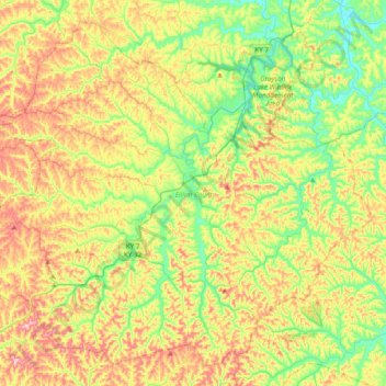
Name: Elliott County topographic map, elevation, terrain.

Location: Elliott County, Kentucky, United States (37.99836 -83.27077 38.26688 -82.88850)

Average elevation: 278 m

Minimum elevation: 180 m

Maximum elevation: 416 m

Other topographic maps

Click on a map to view its topography, its elevation and its terrain.

Highway

United States > Kentucky > Clinton County

Average elevation: 287 m

Gibralter

United States > Kentucky > Crittenden County

Average elevation: 136 m

Edna

United States > Kentucky > Magoffin County

Average elevation: 293 m

Freeburn

United States > Kentucky > Pike County

Average elevation: 342 m

Trixie

United States > Kentucky > Clay County

Average elevation: 294 m

Kenwood

United States > Kentucky > Jefferson County > Louisville

Average elevation: 153 m

Riverview

United States > Kentucky > Greenup County > Russell

Average elevation: 182 m

Fords Creek

United States > Kentucky > Trigg County

Average elevation: 135 m

Greendale

United States > Kentucky > Fayette County > Lexington

Average elevation: 284 m

Finney

United States > Kentucky > Barren County

Average elevation: 187 m

Smiths Creek

United States > Kentucky > Carter County

Average elevation: 313 m

Roberts Bluff

United States > Kentucky > Hopkins County

Average elevation: 121 m

Coal Cliff

United States > Kentucky > Wayne County

Average elevation: 313 m

Shetland

United States > Kentucky > Woodford County

Average elevation: 284 m

Northern

United States > Kentucky > Floyd County > Northern

Average elevation: 285 m

Hammonville

United States > Kentucky > Hart County > Hammonville

Average elevation: 232 m

Charters

United States > Kentucky > Lewis County > Charters

Average elevation: 238 m

Yosemite

United States > Kentucky > Yosemite

Average elevation: 285 m

Lucas

United States > Kentucky > Lucas

Average elevation: 197 m

Glen Springs

United States > Kentucky > Glen Springs

Average elevation: 287 m

Jameison Hill

United States > Kentucky

Average elevation: 161 m

Jeff

United States > Kentucky > Perry County > Jeff

Average elevation: 374 m

Mayfield

United States > Kentucky > Graves County > Mayfield > Mayfield

Average elevation: 148 m

Oakdale

United States > Kentucky > Jefferson County > Louisville > Oakdale

Average elevation: 143 m

Bighill

United States > Kentucky > Madison County > Bighill

Average elevation: 297 m