Simpson County topographic map
Click on the map to display elevation.
About this map

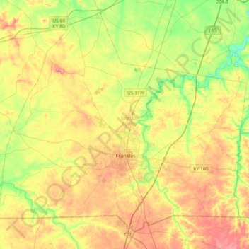
Name: Simpson County topographic map, elevation, terrain.
Location: Simpson County, Kentucky, United States (36.63355 -86.76289 36.88296 -86.40060)
Average elevation: 204 m
Minimum elevation: 142 m
Maximum elevation: 277 m
Other topographic maps
Click on a map to view its topography, its elevation and its terrain.


Trixie
United States > Kentucky > Clay County
Trixie, Clay County, Kentucky, United States
Average elevation: 294 m

Kenwood
United States > Kentucky > Jefferson County > Louisville
Kenwood, Louisville, Jefferson County, Kentucky, 40214, United States
Average elevation: 153 m

Riverview
United States > Kentucky > Greenup County > Russell
Riverview, Russell, Greenup County, Kentucky, 45638, United States
Average elevation: 182 m

Winchester
United States > Kentucky > Clark County
Winchester, Clark County, Kentucky, United States
Average elevation: 296 m

Fords Creek
United States > Kentucky > Trigg County
Fords Creek, Trigg County, Kentucky, United States
Average elevation: 135 m

Greendale
United States > Kentucky > Fayette County > Lexington
Greendale, Lexington, Fayette County, Kentucky, 40511, United States
Average elevation: 284 m

Finney
United States > Kentucky > Barren County
Finney, Barren County, Kentucky, United States
Average elevation: 187 m


Smiths Creek
United States > Kentucky > Carter County
Smiths Creek, Carter County, Kentucky, 41128, United States
Average elevation: 313 m

Glenview
United States > Kentucky > Jefferson County
Glenview, Jefferson County, Kentucky, 40025, United States
Average elevation: 155 m

Newport
United States > Kentucky > Campbell County
Newport, Campbell County, Kentucky, 41071, United States
Average elevation: 173 m

Roberts Bluff
United States > Kentucky > Hopkins County
Roberts Bluff, Hopkins County, Kentucky, United States
Average elevation: 121 m


Coal Cliff
United States > Kentucky > Wayne County
Coal Cliff, Wayne County, Kentucky, United States
Average elevation: 313 m