
고흥군 topographic map
Interactive map
Click on the map to display elevation.
About this map
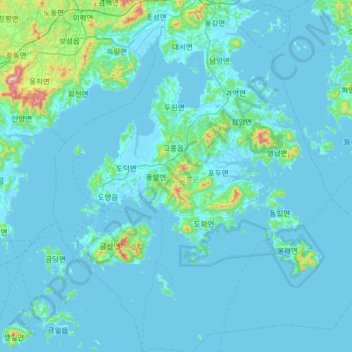
Name: 고흥군 topographic map, elevation, terrain.
Location: 고흥군, Jeolla del Sur, Corea del Sur (34.29750 127.04950 34.82871 127.63693)
Average elevation: 44 m
Minimum elevation: -3 m
Maximum elevation: 757 m
Other topographic maps
Click on a map to view its topography, its elevation and its terrain.
송지리
송지리, Yecheon, Gyeongsang del Norte, 36843, Corea del Sur
Average elevation: 127 m
덕촌리
덕촌리, Yangpyeong, Gyeonggi, 12511, Corea del Sur
Average elevation: 186 m
Yecheon
Corea del Sur > Gyeongsang del Norte
Yecheon, Gyeongsang del Norte, 36830, Corea del Sur
Average elevation: 348 m