
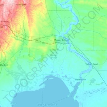
The Rural City of Murray Bridge topographic map
Interactive map
Click on the map to display elevation.
About this map
Name: The Rural City of Murray Bridge topographic map, elevation, terrain.
Average elevation: 76 m
Minimum elevation: -2 m
Maximum elevation: 540 m
South Australia trails, hiking, mountain biking, running and outdoor activities
Other topographic maps
Click on a map to view its topography, its elevation and its terrain.
Adelaide
Australia > South Australia > Adelaide
Adelaide is north of the Fleurieu Peninsula, on the Adelaide Plains between the Gulf St Vincent and the low-lying Mount Lofty Ranges. The city stretches 20 km (12 mi) from the coast to the foothills, and 90 km (56 mi) from Gawler at its northern extent to Sellicks Beach in the south. According to the Regional…
Average elevation: 148 m
Cape Finnis
Australia > South Australia > District Council of Elliston > Elliston
Average elevation: 5 m
Stokes Hill Lookout
Australia > South Australia > Pastoral Unincorporated Area
Average elevation: 684 m
Dullingari
Australia > South Australia > Pastoral Unincorporated Area > Innamincka
Average elevation: 89 m
Bookabourdie Waterhole
Australia > South Australia > Pastoral Unincorporated Area > Innamincka
Average elevation: 44 m
Cape Finnis
Australia > South Australia > District Council of Elliston > Elliston
Average elevation: 5 m
Victoria Square
Australia > South Australia > Adelaide City Council > Adelaide
Average elevation: 47 m
Flagstaff Hill
Australia > South Australia > The District Council of Loxton Waikerie
Average elevation: 27 m
Happy Valley Reservoir
Australia > South Australia > City of Onkaparinga > Adelaide
Average elevation: 164 m
Marble Hill
Australia > South Australia > Anangu Pitjantjatjara Yankunytjatjara
Average elevation: 480 m
Happy Valley Reservior
Australia > South Australia > City of Onkaparinga > Adelaide
Average elevation: 173 m
Mount Compass
Australia > South Australia > Alexandrina Council > Mount Compass
Average elevation: 275 m
Lake Bonney Riverland
Australia > South Australia > The Berri Barmera Council > Barmera
Average elevation: 16 m
Shallow Lagoon
Australia > South Australia > Yorke Peninsula Council > Minlaton
Average elevation: 77 m
Kalumunda Forest Reserve
Australia > South Australia > The District Council of Yankalilla
Average elevation: 265 m
Blue Lake
Australia > South Australia > Mount Gambier
During December to March, the lake turns to a vibrant cobalt blue colour, returning to a colder steel grey colour for April to November. The exact cause of this phenomenon is still a matter of conjecture, but likely it involves the warming of the surface layers of the lake during the summer to around 20 °C…
Average elevation: 53 m
Port Noarlunga Reef Sanctuary Zone
Australia > South Australia > City of Onkaparinga > Adelaide
Average elevation: 1 m
Myponga River
Australia > South Australia > The District Council of Yankalilla > Myponga > Myponga Beach
Average elevation: 138 m
Mallee Dam
Australia > South Australia > The District Council of Peterborough
Average elevation: 328 m
Kenneth Stirling Conservation Park - Wottons Scrub
Australia > South Australia > Balhannah
Average elevation: 438 m
Adelaide (Sellicks Hill) Weather Radar
Australia > South Australia > City of Onkaparinga > Adelaide
Average elevation: 291 m
Streaky Bay
Australia > South Australia > The District Council of Streaky Bay > Streaky Bay
Average elevation: 22 m