Geolocate

Lom topographic map

Click on the map to display elevation.

About this map

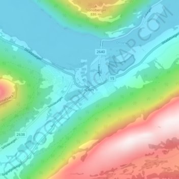
Name: Lom topographic map, elevation, terrain.

Location: Lom, Innlandet, 2686, Norway (61.81771 8.54841 61.85771 8.58841)

Average elevation: 600 m

Minimum elevation: 360 m

Maximum elevation: 1,213 m

Other topographic maps

Click on a map to view its topography, its elevation and its terrain.

Ringebu

Norway > Innlandet

Average elevation: 911 m

Skjåk

Norway > Innlandet

Average elevation: 1,305 m

Stor-Elvdal

Norway > Innlandet

Average elevation: 763 m

Broka

Norway > Innlandet

Average elevation: 428 m

Gausdal

Norway > Innlandet

Average elevation: 851 m

Rendalen

Norway > Innlandet

Average elevation: 783 m

Sør-Aurdal

Norway > Innlandet

Average elevation: 690 m

Ringsaker

Norway > Innlandet

Average elevation: 472 m

Lom

Norway > Innlandet

Average elevation: 1,327 m

Gran

Norway > Innlandet

Average elevation: 407 m

Østre Toten

Norway > Innlandet

Average elevation: 365 m

Tundra

Norway > Innlandet

Average elevation: 1,279 m

Vestre Slidre

Norway > Innlandet

Average elevation: 878 m

Etnedal

Norway > Innlandet

Average elevation: 788 m

Gear up for your next adventure:

🩹Wilderness First Aid Kits - Comprehensive medical kits tailored for hiking and remote exploration
Lightweight Tents - Compact tents for backpacking
🚗Car Camping Gear - Equipment for vehicle camping
Ultralight Solo Tents - Compact shelters for multi-day topographic surveying expeditions
📡Weather Radios - Emergency weather radios

As an Amazon Associate, this site earns from qualifying purchases at no extra cost to you.