Geolocate

Gran topographic map

Click on the map to display elevation.

About this map

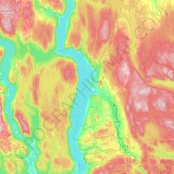
Name: Gran topographic map, elevation, terrain.

Location: Gran, Innlandet, Norway (60.31207 10.12481 60.56481 10.93390)

Average elevation: 407 m

Minimum elevation: 125 m

Maximum elevation: 797 m

Other topographic maps

Click on a map to view its topography, its elevation and its terrain.

Rena

Norway > Innlandet

Average elevation: 281 m

Fall

Norway > Innlandet

Average elevation: 259 m

Brigaden

Norway > Innlandet

Average elevation: 474 m

To

Norway > Innlandet > Otta

Average elevation: 583 m

Lillehammer

Norway > Innlandet

Average elevation: 360 m

Tynset

Norway > Innlandet

Average elevation: 596 m

Otta

Norway > Innlandet

Average elevation: 719 m

Beitostølen

Norway > Innlandet

Average elevation: 914 m

Lom

Norway > Innlandet

Average elevation: 600 m

Bjorli

Norway > Innlandet

Average elevation: 686 m

Tundra

Norway > Innlandet

Average elevation: 1,279 m

Ottestad

Norway > Innlandet > Ottestad

Average elevation: 192 m

Flisa

Norway > Innlandet

Average elevation: 195 m

Alstad

Norway > Innlandet > Lena

Average elevation: 262 m

Gear up for your next adventure:

🔭Compact Hiking Binoculars - Lightweight optics for scouting routes or birdwatching
🚴Cycling Backpacks - Backpacks for cyclists
🧼Biodegradable Outdoor Soap - Clean gear and yourself without harming the local ecosystem
🧺Waterproof Dry Sacks - Organize your pack and keep electronics safe from rain and river crossings
👖Convertible Hiking Trousers - Zip-off legs to adapt to changing temperatures throughout the day

As an Amazon Associate, this site earns from qualifying purchases at no extra cost to you.