Geolocate

Flisa topographic map

Click on the map to display elevation.

About this map

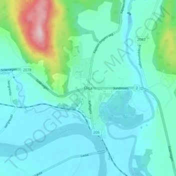
Name: Flisa topographic map, elevation, terrain.

Location: Flisa, Åsnes, Innlandet, 2270, Norway (60.59317 11.99089 60.63317 12.03089)

Average elevation: 195 m

Minimum elevation: 148 m

Maximum elevation: 426 m

Other topographic maps

Click on a map to view its topography, its elevation and its terrain.

Skjåk

Norway > Innlandet

Average elevation: 1,305 m

Broka

Norway > Innlandet

Average elevation: 428 m

Sør-Aurdal

Norway > Innlandet

Average elevation: 690 m

Stor-Elvdal

Norway > Innlandet

Average elevation: 763 m

Ringsaker

Norway > Innlandet

Average elevation: 472 m

Gausdal

Norway > Innlandet

Average elevation: 851 m

Lom

Norway > Innlandet

Average elevation: 1,327 m

Østre Toten

Norway > Innlandet

Average elevation: 365 m

Ringebu

Norway > Innlandet

Average elevation: 911 m

Gran

Norway > Innlandet

Average elevation: 407 m

Tundra

Norway > Innlandet

Average elevation: 1,279 m

Vestre Slidre

Norway > Innlandet

Average elevation: 878 m

Rendalen

Norway > Innlandet

Average elevation: 783 m

Etnedal

Norway > Innlandet

Average elevation: 788 m

Gear up for your next adventure:

🍶Collapsible Water Bottles - Save space in your pack as you consume your water supply
🧺Fast-Dry Microfiber Towels - Large towels that pack down to the size of an orange
🧥Softshell Jackets - Flexible outdoor jackets
🔥Camping Stoves - Portable stoves for outdoor cooking
🔥Ferrocerium Rod Fire Starters - Reliable fire lighting in wet or windy conditions without matches

As an Amazon Associate, this site earns from qualifying purchases at no extra cost to you.