Geolocate
👉 Easily get elevation data in JSON, GeoTIFF and KML formats using Elevation API
Thank you for supporting this site ❤️
Make a donation

Gear up for your next adventure:

As an Amazon Associate, this site earns from qualifying purchases at no extra cost to you.

Otta topographic map

Click on the map to display elevation.

About this map

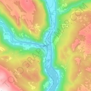
Name: Otta topographic map, elevation, terrain.

Location: Otta, Sel, Innlandet, 2670, Norway (61.73124 9.49525 61.81124 9.57525)

Average elevation: 719 m

Minimum elevation: 280 m

Maximum elevation: 1,364 m

Other topographic maps

Click on a map to view its topography, its elevation and its terrain.

Ringebu

Norway > Innlandet

Average elevation: 911 m

Lom

Norway > Innlandet

Average elevation: 1,327 m

Gausdal

Norway > Innlandet

Average elevation: 851 m

Tundra

Norway > Innlandet

Average elevation: 1,279 m

Rendalen

Norway > Innlandet

Average elevation: 783 m

Gran

Norway > Innlandet

Average elevation: 407 m

Stor-Elvdal

Norway > Innlandet

Average elevation: 763 m

Broka

Norway > Innlandet

Average elevation: 428 m

Skjåk

Norway > Innlandet

Average elevation: 1,305 m

Ringsaker

Norway > Innlandet

Average elevation: 472 m

Sør-Aurdal

Norway > Innlandet

Average elevation: 690 m

Etnedal

Norway > Innlandet

Average elevation: 788 m

Østre Toten

Norway > Innlandet

Average elevation: 365 m

Vestre Slidre

Norway > Innlandet

Average elevation: 878 m

Gear up for your next adventure:

Altimeter Watches - Watches with altitude tracking
🦯Trekking Poles - Walking poles for hiking stability
🎒Ultralight Backpacks - Lightweight packs for long hikes
🛌Sleeping Bags - Sleeping bags for outdoor camping
📱Tablet Tripod Mounts - Steady platforms for viewing digital maps or taking long exposures

As an Amazon Associate, this site earns from qualifying purchases at no extra cost to you.