Geolocate

Fall topographic map

Click on the map to display elevation.

About this map

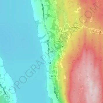
Name: Fall topographic map, elevation, terrain.

Location: Fall, Søndre Land, Innlandet, 2864, Norway (60.65175 10.34346 60.69175 10.38346)

Average elevation: 259 m

Minimum elevation: 127 m

Maximum elevation: 516 m

Other topographic maps

Click on a map to view its topography, its elevation and its terrain.

Ringebu

Norway > Innlandet

Average elevation: 911 m

Lom

Norway > Innlandet

Average elevation: 1,327 m

Gausdal

Norway > Innlandet

Average elevation: 851 m

Tundra

Norway > Innlandet

Average elevation: 1,279 m

Rendalen

Norway > Innlandet

Average elevation: 783 m

Gran

Norway > Innlandet

Average elevation: 407 m

Stor-Elvdal

Norway > Innlandet

Average elevation: 763 m

Broka

Norway > Innlandet

Average elevation: 428 m

Skjåk

Norway > Innlandet

Average elevation: 1,305 m

Ringsaker

Norway > Innlandet

Average elevation: 472 m

Sør-Aurdal

Norway > Innlandet

Average elevation: 690 m

Etnedal

Norway > Innlandet

Average elevation: 788 m

Østre Toten

Norway > Innlandet

Average elevation: 365 m

Vestre Slidre

Norway > Innlandet

Average elevation: 878 m

Gear up for your next adventure:

📻Handheld UHF Radios - Critical communication for groups in the Australian outback
🧴SPF 50+ Bulk Sunscreen - Maximum protection for long-term outdoor exposure
🩹Wilderness First Aid Kits - Comprehensive medical kits tailored for hiking and remote exploration
📱Tablet Tripod Mounts - Steady platforms for viewing digital maps or taking long exposures
🛌Sleeping Mats - Insulated mats for camping comfort

As an Amazon Associate, this site earns from qualifying purchases at no extra cost to you.