Geolocate

Tynset topographic map

Click on the map to display elevation.

About this map

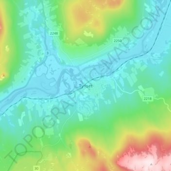
Name: Tynset topographic map, elevation, terrain.

Location: Tynset, Innlandet, Norway (62.23429 10.73687 62.31429 10.81687)

Average elevation: 596 m

Minimum elevation: 475 m

Maximum elevation: 1,011 m

Other topographic maps

Click on a map to view its topography, its elevation and its terrain.

Ringebu

Norway > Innlandet

Average elevation: 911 m

Lom

Norway > Innlandet

Average elevation: 1,327 m

Gausdal

Norway > Innlandet

Average elevation: 851 m

Tundra

Norway > Innlandet

Average elevation: 1,279 m

Rendalen

Norway > Innlandet

Average elevation: 783 m

Gran

Norway > Innlandet

Average elevation: 407 m

Stor-Elvdal

Norway > Innlandet

Average elevation: 763 m

Broka

Norway > Innlandet

Average elevation: 428 m

Skjåk

Norway > Innlandet

Average elevation: 1,305 m

Ringsaker

Norway > Innlandet

Average elevation: 472 m

Sør-Aurdal

Norway > Innlandet

Average elevation: 690 m

Etnedal

Norway > Innlandet

Average elevation: 788 m

Østre Toten

Norway > Innlandet

Average elevation: 365 m

Vestre Slidre

Norway > Innlandet

Average elevation: 878 m

Gear up for your next adventure:

🆘Personal Locator Beacons (PLB) - Satellite emergency beacons for life-saving help in areas with no mobile coverage
🔌Fast Charging Adapters - Quickly top up all your gear before heading back into the field
📟Satellite Messengers - Two-way satellite communication to stay in touch beyond the cellular grid
🎒Daypacks - Compact backpacks for short hikes
🧺Waterproof Dry Sacks - Organize your pack and keep electronics safe from rain and river crossings

As an Amazon Associate, this site earns from qualifying purchases at no extra cost to you.