Geolocate

Beitostølen topographic map

Click on the map to display elevation.

About this map

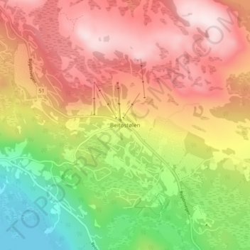
Name: Beitostølen topographic map, elevation, terrain.

Location: Beitostølen, Øystre Slidre, Innlandet, 2953, Norway (61.22872 8.88626 61.26872 8.92626)

Average elevation: 914 m

Minimum elevation: 675 m

Maximum elevation: 1,123 m

Other topographic maps

Click on a map to view its topography, its elevation and its terrain.

Skjåk

Norway > Innlandet

Average elevation: 1,305 m

Gausdal

Norway > Innlandet

Average elevation: 851 m

Sør-Aurdal

Norway > Innlandet

Average elevation: 690 m

Stor-Elvdal

Norway > Innlandet

Average elevation: 763 m

Ringsaker

Norway > Innlandet

Average elevation: 472 m

Broka

Norway > Innlandet

Average elevation: 428 m

Rendalen

Norway > Innlandet

Average elevation: 783 m

Ringebu

Norway > Innlandet

Average elevation: 911 m

Lom

Norway > Innlandet

Average elevation: 1,327 m

Gran

Norway > Innlandet

Average elevation: 407 m

Østre Toten

Norway > Innlandet

Average elevation: 365 m

Tundra

Norway > Innlandet

Average elevation: 1,279 m

Vestre Slidre

Norway > Innlandet

Average elevation: 878 m

Etnedal

Norway > Innlandet

Average elevation: 788 m

Gear up for your next adventure:

🧥Down Jackets - Insulated jackets for cold weather
🌿Flora and Fauna Field Guides - Identify the plants and animals you encounter on your route
🥾Trail Running Shoes - Shoes for trail running
👣Snake & Scrub Gaiters - Protection against spinifex, mud, and snakes while walking off-track
🧰Survival Kits - Essential survival gear

As an Amazon Associate, this site earns from qualifying purchases at no extra cost to you.