
Punjab topographic map
Interactive map
Click on the map to display elevation.
About this map
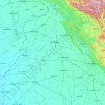
Name: Punjab topographic map, elevation, terrain.
Location: Punjab, India (29.54294 73.87983 32.51118 76.93906)
Average elevation: 477 m
Minimum elevation: 170 m
Maximum elevation: 6,027 m
Punjab is in northwestern India and has a total area of 50,362 square kilometres (19,445 sq mi). Punjab is bounded by Pakistan on the west, Jammu and Kashmir on the north, Himachal Pradesh on the northeast and Haryana and Rajasthan on the south. Most of the Punjab lies in a fertile, alluvial plain with many rivers and an extensive irrigation canal system. A belt of undulating hills extends along the northeastern part of the state at the foot of the Himalayas. Its average elevation is 300 metres (980 ft) above sea level, with a range from 180 metres (590 ft) in the southwest to more than 500 metres (1,600 ft) around the northeast border. The southwest of the state is semiarid, eventually merging into the Thar Desert. The Shiwalik Hills extend along the northeastern part of the state at the foot of the Himalayas.
Other topographic maps
Click on a map to view its topography, its elevation and its terrain.
Dharamshala
India > Himachal Pradesh > Dharamshala
Dharamshala, Kangra District, Himachal Pradesh, 176200, India
Average elevation: 1,781 m
Bangalore East
Bangalore East, Bengaluru Urban, Karnataka, India
Average elevation: 889 m
Coimbatore
India > Tamil Nadu > Coimbatore North
Coimbatore, Coimbatore North, Coimbatore District, Tamil Nadu, 641001, India
Average elevation: 452 m
Lucknow
India > Uttar Pradesh > Lucknow
Lucknow, Lucknow District, Uttar Pradesh, 226027, India
Average elevation: 120 m
Mohali
India > Madhya Pradesh > Rehli Tahsil
Mohali, Rehli Tahsil, Sagar District, Madhya Pradesh, India
Average elevation: 430 m
Dharav Parav
India > Madhya Pradesh > Bankhedi Tahsil
Dharav Parav, Bankhedi Tahsil, Narmadapuram District, Madhya Pradesh, India
Average elevation: 378 m
Kashipur
India > Uttarakhand > Kashipur
Kashipur, Udham Singh Nagar District, Uttarakhand, 244713, India
Average elevation: 233 m
Bhagsu
India > Himachal Pradesh > Dharamshala
Bhagsu, Dharamshala, Kangra District, Himachal Pradesh, 176219, India
Average elevation: 1,955 m
Tholpetty
India > Kerala > Mananthavady
Tholpetty, Mananthavady, Wayanad District, Kerala, 571250, India
Average elevation: 875 m
Rampura
India > Gujarat > Detroj Rampura Taluka
Rampura, Detroj Rampura Taluka, Ahmedabad District, Gujarat, 382140, India
Average elevation: 42 m
Dantiwada dam
India > Gujarat > Dantiwada Taluka > Dantiwada
Dantiwada dam, Dantiwada, Dantiwada Taluka, Banaskantha District, Gujarat, 385505, India
Average elevation: 170 m
Gullah
India > Punjab > Guruharsahai Tahsil
Gullah, Guruharsahai Tahsil, Firozpur District, Punjab, 152024, India
Average elevation: 187 m
Machilipatnam
India > Andhra Pradesh > Machilipatnam
Machilipatnam, Krishna, Andhra Pradesh, 521001, India
Average elevation: 4 m
Thrikkunnapuzha
India > Kerala > Karthikappally
Thrikkunnapuzha, Karthikappally, Alappuzha District, Kerala, 690516, India
Average elevation: 2 m
Jaipur
India > Rajasthan > Jaipur Tehsil
Jaipur, Jaipur Municipal Corporation, Jaipur Tehsil, Jaipur, Rajasthan, 302001, India
Average elevation: 408 m
Maranda
India > Madhya Pradesh > Baihar Tahsil
Maranda, Baihar Tahsil, Balaghat District, Madhya Pradesh, India
Average elevation: 641 m
Waruda
India > Maharashtra > Teosa
Waruda, Teosa, Amravati, Maharashtra, India
Average elevation: 335 m
Mundi
India > Madhya Pradesh > Damoh Tahsil
Mundi, Damoh Tahsil, Damoh District, Madhya Pradesh, India
Average elevation: 364 m
Galore
Galore, Hamirpur District, Himachal Pradesh, 177006, India
Average elevation: 693 m
Suryapet
India > Telangana > Suryapet mandal
Suryapet, Suryapet mandal, Suryapet District, Telangana, 508213, India
Average elevation: 180 m
Vallapuzha
Vallapuzha, Pattambi, Palakkad District, Kerala, 679335, India
Average elevation: 56 m
Jaynagar - I
Jaynagar - I, South 24 Parganas District, West Bengal, India
Average elevation: 4 m
Bargara
India > Madhya Pradesh > Chitrangi Tahsil
Bargara, Chitrangi Tahsil, Singrauli District, Madhya Pradesh, India
Average elevation: 211 m
Kerla
India > Rajasthan > Pali Tehsil
Kerla, Pali Tehsil, Pali District, Rajasthan, India
Average elevation: 199 m
Rajkot
India > Gujarat > Rajkot East Taluka
Rajkot, Rajkot East Taluka, Rajkot District, Gujarat, 360001, India
Average elevation: 141 m
Bering
India > Punjab > Mukerian Tahsil
Bering, Mukerian Tahsil, Hoshiarpur District, Punjab, 144223, India
Average elevation: 622 m
Papan
India > Madhya Pradesh > Seoni-Malwa Tahsil
Papan, Seoni-Malwa Tahsil, Narmadapuram District, Madhya Pradesh, India
Average elevation: 281 m
Puducherry
India > Puducherry > Puducherry Taluk
Puducherry, Puducherry Taluk, Puducherry District, Puducherry, 605001, India
Average elevation: 10 m
Malak
India > Punjab > Kharar Tahsil
Malak, Kharar Tahsil, Sahibzada Ajit Singh Nagar District, Punjab, 140901, India
Average elevation: 352 m
Tharwa
India > Madhya Pradesh > Harrai Tahsil
Tharwa, Harrai Tahsil, Chhindwara District, Madhya Pradesh, India
Average elevation: 644 m
Sukma
India > Chhattisgarh > Sukma Tahsil
Sukma, Sukma Tahsil, Sukma District, Chhattisgarh, 494111, India
Average elevation: 219 m
Sullurpeta
India > Andhra Pradesh > Sullurpeta
Sullurpeta, Tirupati District, Andhra Pradesh, 524121, India
Average elevation: 4 m