
Kastamonu topographic map
Interactive map
Click on the map to display elevation.
About this map
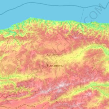
Name: Kastamonu topographic map, elevation, terrain.
Location: Kastamonu, Black Sea Region, Turkey (40.81970 32.65654 42.21900 34.60676)
Average elevation: 833 m
Minimum elevation: 0 m
Maximum elevation: 2,542 m
Kastamonu is the capital district of the Kastamonu Province, Turkey. According to the 2000 census, population of the district is 102,059 of which 64,606 live in the urban center of Kastamonu. (Population of the urban center in 2010 is 91,012.) The district covers an area of 1,834 km2 (708 sq mi), and the town lies at an elevation of 904 m (2,966 ft). It is located to the south of the province.
Other topographic maps
Click on a map to view its topography, its elevation and its terrain.
Ballık
Ballık, Altınyayla, Burdur, Mediterranean Region, Turkey
Average elevation: 1,528 m
Bezirhane Mahallesi
Bezirhane Mahallesi, Gölbaşı, Ankara, Central Anatolia Region, Turkey
Average elevation: 1,158 m
Bıçakcılar
Bıçakcılar, Yusufeli, Artvin, Black Sea Region, Turkey
Average elevation: 1,833 m
Eskisehir
Eskisehir, Odunpazarı, Eskişehir, Central Anatolia Region, 26120, Turkey
Average elevation: 949 m
İshakçelebi
İshakçelebi, Saruhanlı, Manisa, Aegean Region, Turkey
Average elevation: 55 m
Akşemsettin Mahallesi
Akşemsettin Mahallesi, Eyüpsultan, Istanbul, Marmara Region, 34070, Turkey
Average elevation: 62 m
Camuzcu Mahallesi
Camuzcu Mahallesi, Seyhan, Adana, Mediterranean Region, Turkey
Average elevation: 13 m