
Çankırı topographic map
Interactive map
Click on the map to display elevation.
About this map
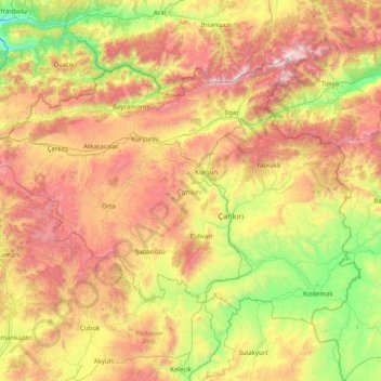
Name: Çankırı topographic map, elevation, terrain.
Location: Çankırı, Central Anatolia Region, Turkey (40.25480 32.56918 41.08917 34.16569)
Average elevation: 1,134 m
Minimum elevation: 304 m
Maximum elevation: 2,526 m
Çankırı has a dry summer continental climate (Köppen climate classification Dsa and Dsb) with humid continental climate (Dfa and Dfb) characteristics, since the wettest part of the year is spring and early summer. The province displays all four of these continental climate subtypes depending on location and elevation. The city is located in a transitional region of the province. Summers are usually hot and dry and winters are cold and snowy.
Other topographic maps
Click on a map to view its topography, its elevation and its terrain.
Ballık
Ballık, Altınyayla, Burdur, Mediterranean Region, Turkey
Average elevation: 1,528 m
Bezirhane Mahallesi
Bezirhane Mahallesi, Gölbaşı, Ankara, Central Anatolia Region, Turkey
Average elevation: 1,158 m
Bıçakcılar
Bıçakcılar, Yusufeli, Artvin, Black Sea Region, Turkey
Average elevation: 1,833 m
Eskisehir
Eskisehir, Odunpazarı, Eskişehir, Central Anatolia Region, 26120, Turkey
Average elevation: 949 m
İshakçelebi
İshakçelebi, Saruhanlı, Manisa, Aegean Region, Turkey
Average elevation: 55 m
Akşemsettin Mahallesi
Akşemsettin Mahallesi, Eyüpsultan, Istanbul, Marmara Region, 34070, Turkey
Average elevation: 62 m
Camuzcu Mahallesi
Camuzcu Mahallesi, Seyhan, Adana, Mediterranean Region, Turkey
Average elevation: 13 m