
Philippines topographic map
Click on the map to display elevation.
Philippines
The Philippines is an archipelago of approximately 7,641 islands, with a total land area of about 300,000 square kilometers. The terrain is predominantly mountainous, with narrow coastal plains and valleys. The highest peak is Mount Apo on Mindanao, reaching 2,954 meters (9,692 feet) above sea level. Other notable mountains include Mount Pulag in Luzon and Mount Dulang-Dulang in Mindanao. The Sierra Madre mountain range, the longest in the Philippines, stretches along the eastern side of Luzon. The country is also home to several active volcanoes, such as Mayon, Taal, and Canlaon, contributing to its varied topography. The extensive coastline, measuring 36,289 kilometers (22,549 miles), features numerous bays, coves, and inlets, with Manila Bay being one of the finest harbors in East Asia. The Philippines' diverse landscape includes fertile plains like the Central Luzon plains, known as the "Rice Bowl of the Philippines," and the Cagayan Valley, which is the country's longest river system. The varied terrain has led to a rich biodiversity, with tropical rainforests providing habitats for numerous species. The country's location along the Pacific Ring of Fire makes it prone to earthquakes and volcanic activity, further shaping its dynamic landscape.
About this map
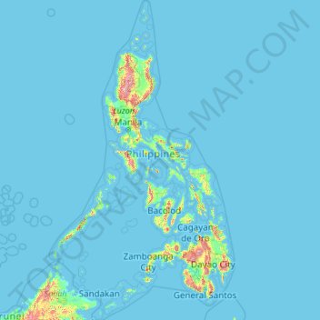
Name: Philippines topographic map, elevation, terrain.
Location: Philippines (4.38333 114.10037 21.32193 126.80308)
Average elevation: 33 m
Minimum elevation: -1 m
Maximum elevation: 2,639 m
Other topographic maps
Click on a map to view its topography, its elevation and its terrain.
Perth
Perth, the capital of Western Australia, is situated on the Swan Coastal Plain, a flat expanse of sandy soil nestled between the Indian Ocean to the west and the Darling Scarp to the east. The Darling Scarp, also known as the Darling Range, is a low escarpment that extends north–south, marking a distinct…
Average elevation: 26 m
Canberra
The area chosen for the capital had been inhabited by Indigenous Australians for up to 21,000 years, with the principal group being the Ngunnawal people. European settlement commenced in the first half of the 19th century, as evidenced by surviving landmarks such as St John's Anglican Church and Blundells…
Average elevation: 638 m
Adelaide
Australia > South Australia > Adelaide
Adelaide is north of the Fleurieu Peninsula, on the Adelaide Plains between the Gulf St Vincent and the low-lying Mount Lofty Ranges. The city stretches 20 km (12 mi) from the coast to the foothills, and 90 km (56 mi) from Gawler at its northern extent to Sellicks Beach in the south. According to the Regional…
Average elevation: 148 m
Great Dividing Range
The Great Dividing Range, also known as the East Australian Cordillera or the Eastern Highlands, is a cordillera system in eastern Australia consisting of an expansive collection of mountain ranges, plateaus and rolling hills, that runs roughly parallel to the east coast of Australia and forms the…
Average elevation: 117 m
Toowoomba
The city occupies the edge of the range and the low ridges behind it. Two valleys run north from the southern boundary, each arising from springs either side of Middle Ridge near Spring Street at an altitude of around 680 m. These waterways, East Creek and West Creek, flow together just north of the CBD to…
Average elevation: 458 m
Cairns
South of Smithfield and inland from the Northern Beaches along the edge of the Barron River flood plain are the suburbs of Caravonica, Kamerunga, Freshwater, and Stratford. This area is sometimes referred to as Freshwater Valley, though it is actually the lower part of Redlynch Valley; further up the valley…
Average elevation: 176 m
Ballarat
Ballarat has a moderate oceanic climate (Köppen climate classification Cfb) with four distinct seasons. Its elevation, ranging between 400 and 630 metres (1,310 and 2,070 feet) above sea level, causes its mean monthly temperatures to tend to be on average 3 to 5 °C (5 to 9 °F) below those of Melbourne,…
Average elevation: 470 m
Sunshine Coast
Australia > Queensland > Sunshine Coast Regional
The Sunshine Coast in Queensland, Australia, showcases a diverse topography that harmoniously blends coastal plains with rugged hinterlands. Along its eastern edge, the region features expansive sandy beaches and coastal dunes that transition smoothly into fertile lowlands. Inland, the terrain becomes more…
Average elevation: 109 m
Melbourne
Melbourne is also prone to isolated convective showers forming when a cold pool crosses the state, especially if there is considerable daytime heating. These showers are often heavy and can include hail, squalls, and significant drops in temperature, but they often pass through very quickly with a rapid…
Average elevation: 49 m
Mount Banks
Mount Banks, otherwise known as Mount King George, is a mountain within the Explorers Range of the Blue Mountains Range that is a spur off the Great Dividing Range, is located within the Blue Mountains National Park, approximately 100 kilometres (62 mi) west of Sydney in New South Wales, Australia. Mount Banks…
Average elevation: 745 m
Caloundra
Caloundra, located on Queensland's Sunshine Coast, features a diverse coastal topography characterized by sandy beaches, rocky headlands, and nearby elevated terrains. The suburb of Kings Beach exemplifies this diversity, with its sandy shoreline to the south and southeast, and a rocky headland rising to about…
Average elevation: 5 m
Sydney
Phillip had been given no instructions for urban development, but in July 1788 submitted a plan for the new town at Sydney Cove. It included a wide central avenue, a permanent Government House, law courts, hospital and other public buildings, but no provision for warehouses, shops, or other commercial…
Average elevation: 32 m
Port Neill
Matthew Flinders sailed past on 7 March 1802 and reported 'low front land, somewhat sandy, with raised land inland and of a barren appearance, its elevation diminishing to the northward.' The first land-based European exploration took place in April 1840, when the party of Governor Gawler, John Hill, and…
Average elevation: 9 m
Budawang Range
The highest mountain in the range is Mount Budawang that has an elevation of 1,129 metres (3,704 ft) above sea level.
Average elevation: 484 m
Heard Island
Heard Island, by far the largest of the group, is a 368-square-kilometre (142 sq mi) mountainous island covered by 41 glaciers; 80% of the island is covered with ice. The Big Ben massif dominates the island: It has a maximum elevation of 2,745 metres (9,006 ft) at Mawson Peak, the historically active volcanic…
Average elevation: 120 m
Launceston
Australia > Tasmania > Launceston
Launceston is at 41°26′31″S 147°8′42″E / 41.44194°S 147.14500°E / -41.44194; 147.14500 in the Tamar Valley, Northern Tasmania. The valley was formed by volcanic and glacial forces over 10 million years ago. The city is about 45 kilometres (28 mi) south of the Bass Strait, with its closest…
Average elevation: 218 m
Mawson Peak
With an elevation of 2,745 metres (9,006 ft), it is the third highest peak in any state, territory or claimed territory of Australia, higher than the 2,228-metre (7,310 ft) Mount Kosciuszko, and surpassed only by the 3,490-metre (11,450 ft) Mount McClintock and the 3,355-metre (11,007 ft) Mount Menzies in the…
Average elevation: 2,175 m
MacDonnell Ranges
The highest peaks are Mount Zeil with an elevation of 1,531 metres (5,023 ft) AHD, Mount Liebig at 1,524 metres (5,000 ft) AHD, Mount Edward at 1,423 metres (4,669 ft), Mount Giles at 1,389 metres (4,557 ft) and Mount Sonder at 1,380 metres (4,530 ft) AHD; the five highest mountains in the Northern Territory.…
Average elevation: 594 m
Mount Liebig
Mount Liebig is a mountain with an elevation of 1,274 metres (4,180 ft) AHD in the southern part of the Northern Territory of Australia. It is one of the highest peaks of the MacDonnell Ranges and was named by the explorer Ernest Giles after the German chemist Justus von Liebig. Nearby settlements include…
Average elevation: 920 m