
Make a donation
Gear up for your next adventure:
As an Amazon Associate, this site earns from qualifying purchases at no extra cost to you.
Sweden topographic map
Click on the map to display elevation.
Make a donation
Gear up for your next adventure:
As an Amazon Associate, this site earns from qualifying purchases at no extra cost to you.
Sweden
Sweden's topography is a diverse tapestry shaped by ancient geological processes and glacial activity. In the west, the Scandinavian Mountains form a natural border with Norway, featuring peaks like Kebnekaise, the country's highest point at approximately 2,097 meters. Moving eastward, the terrain transitions into vast forests and rolling hills, interspersed with numerous lakes—Sweden boasts around 95,700 lakes, including Vänern and Vättern, two of Europe's largest. The central region, known as the Central Swedish lowland, is characterized by fertile plains that support agriculture, while the southernmost area, particularly Skåne, features flat, arable lands reminiscent of neighboring Denmark. Along the eastern coastline, the landscape is dotted with archipelagos, comprising thousands of islands and islets, adding to the country's intricate coastal geography. This varied terrain not only defines Sweden's natural beauty but also influences its climate, biodiversity, and human settlement patterns.
Make a donation
Gear up for your next adventure:
As an Amazon Associate, this site earns from qualifying purchases at no extra cost to you.
About this map
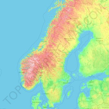
Name: Sweden topographic map, elevation, terrain.
Location: Sweden (55.13710 10.59350 69.05997 24.17768)
Average elevation: 163 m
Minimum elevation: -3 m
Maximum elevation: 2,107 m
Make a donation
Gear up for your next adventure:
As an Amazon Associate, this site earns from qualifying purchases at no extra cost to you.
Other topographic maps
Click on a map to view its topography, its elevation and its terrain.
Perth
Perth, the capital of Western Australia, is situated on the Swan Coastal Plain, a flat expanse of sandy soil nestled between the Indian Ocean to the west and the Darling Scarp to the east. The Darling Scarp, also known as the Darling Range, is a low escarpment that extends north–south, marking a distinct…
Average elevation: 26 m
Canberra
The area chosen for the capital had been inhabited by Indigenous Australians for up to 21,000 years, with the principal group being the Ngunnawal people. European settlement commenced in the first half of the 19th century, as evidenced by surviving landmarks such as St John's Anglican Church and Blundells…
Average elevation: 638 m
Adelaide
Australia > South Australia > Adelaide
Adelaide is north of the Fleurieu Peninsula, on the Adelaide Plains between the Gulf St Vincent and the low-lying Mount Lofty Ranges. The city stretches 20 km (12 mi) from the coast to the foothills, and 90 km (56 mi) from Gawler at its northern extent to Sellicks Beach in the south. According to the Regional…
Average elevation: 148 m
Make a donation
Gear up for your next adventure:
As an Amazon Associate, this site earns from qualifying purchases at no extra cost to you.
Great Dividing Range
The Great Dividing Range, also known as the East Australian Cordillera or the Eastern Highlands, is a cordillera system in eastern Australia consisting of an expansive collection of mountain ranges, plateaus and rolling hills, that runs roughly parallel to the east coast of Australia and forms the…
Average elevation: 117 m
Ballarat
Ballarat has a moderate oceanic climate (Köppen climate classification Cfb) with four distinct seasons. Its elevation, ranging between 400 and 630 metres (1,310 and 2,070 feet) above sea level, causes its mean monthly temperatures to tend to be on average 3 to 5 °C (5 to 9 °F) below those of Melbourne,…
Average elevation: 470 m
Make a donation
Gear up for your next adventure:
As an Amazon Associate, this site earns from qualifying purchases at no extra cost to you.
Melbourne
Melbourne is also prone to isolated convective showers forming when a cold pool crosses the state, especially if there is considerable daytime heating. These showers are often heavy and can include hail, squalls, and significant drops in temperature, but they often pass through very quickly with a rapid…
Average elevation: 49 m
Mount Banks
Mount Banks, otherwise known as Mount King George, is a mountain within the Explorers Range of the Blue Mountains Range that is a spur off the Great Dividing Range, is located within the Blue Mountains National Park, approximately 100 kilometres (62 mi) west of Sydney in New South Wales, Australia. Mount Banks…
Average elevation: 745 m
Sunshine Coast
Australia > Queensland > Sunshine Coast Regional
The Sunshine Coast in Queensland, Australia, showcases a diverse topography that harmoniously blends coastal plains with rugged hinterlands. Along its eastern edge, the region features expansive sandy beaches and coastal dunes that transition smoothly into fertile lowlands. Inland, the terrain becomes more…
Average elevation: 109 m
Make a donation
Gear up for your next adventure:
As an Amazon Associate, this site earns from qualifying purchases at no extra cost to you.
Make a donation
Gear up for your next adventure:
As an Amazon Associate, this site earns from qualifying purchases at no extra cost to you.
Make a donation
Gear up for your next adventure:
As an Amazon Associate, this site earns from qualifying purchases at no extra cost to you.
Mount Kosciuszko
Mount Kosciuszko is the highest summit in mainland Australia. Until 1977 it was possible to drive from Charlotte Pass to within a few metres of the summit, but in 1977 the road was closed to public motor vehicle access due to environmental concerns. The road is open from Charlotte Pass for walkers and cyclists…
Average elevation: 2,035 m
Make a donation
Gear up for your next adventure:
As an Amazon Associate, this site earns from qualifying purchases at no extra cost to you.
Make a donation
Gear up for your next adventure:
As an Amazon Associate, this site earns from qualifying purchases at no extra cost to you.
Little Saint James Island
United States > United States Virgin Islands > Saint Thomas - Saint John District
Average elevation: 1 m
Cairns
South of Smithfield and inland from the Northern Beaches along the edge of the Barron River flood plain are the suburbs of Caravonica, Kamerunga, Freshwater, and Stratford. This area is sometimes referred to as Freshwater Valley, though it is actually the lower part of Redlynch Valley; further up the valley…
Average elevation: 176 m
Make a donation
Gear up for your next adventure:
As an Amazon Associate, this site earns from qualifying purchases at no extra cost to you.
Make a donation
Gear up for your next adventure:
As an Amazon Associate, this site earns from qualifying purchases at no extra cost to you.
Make a donation
Gear up for your next adventure:
As an Amazon Associate, this site earns from qualifying purchases at no extra cost to you.
Toowoomba
The city occupies the edge of the range and the low ridges behind it. Two valleys run north from the southern boundary, each arising from springs either side of Middle Ridge near Spring Street at an altitude of around 680 m. These waterways, East Creek and West Creek, flow together just north of the CBD to…
Average elevation: 458 m
Make a donation
Gear up for your next adventure:
As an Amazon Associate, this site earns from qualifying purchases at no extra cost to you.
Make a donation
Gear up for your next adventure:
As an Amazon Associate, this site earns from qualifying purchases at no extra cost to you.
Sydney
Phillip had been given no instructions for urban development, but in July 1788 submitted a plan for the new town at Sydney Cove. It included a wide central avenue, a permanent Government House, law courts, hospital and other public buildings, but no provision for warehouses, shops, or other commercial…
Average elevation: 32 m
Make a donation
Gear up for your next adventure:
As an Amazon Associate, this site earns from qualifying purchases at no extra cost to you.
Make a donation
Gear up for your next adventure:
As an Amazon Associate, this site earns from qualifying purchases at no extra cost to you.
Wellington
New Zealand > Wellington > Wellington City
Averaging 2,055 hours of sunshine per year, the climate of Wellington is temperate marine, (Köppen: Cfb), generally moderate all year round with warm summers and mild winters, and rarely sees temperatures above 23 °C (73 °F) or below 4 °C (39 °F). The hottest recorded temperature in the city is 31.1 °C…
Average elevation: 85 m
Make a donation
Gear up for your next adventure:
As an Amazon Associate, this site earns from qualifying purchases at no extra cost to you.
Caloundra
Australia > Queensland > Sunshine Coast Regional
Caloundra, located on Queensland's Sunshine Coast, features a diverse coastal topography characterized by sandy beaches, rocky headlands, and nearby elevated terrains. The suburb of Kings Beach exemplifies this diversity, with its sandy shoreline to the south and southeast, and a rocky headland rising to about…
Average elevation: 5 m
Mawson Peak
With an elevation of 2,745 metres (9,006 ft), it is the third highest peak in any state, territory or claimed territory of Australia, higher than the 2,228-metre (7,310 ft) Mount Kosciuszko, and surpassed only by the 3,490-metre (11,450 ft) Mount McClintock and the 3,355-metre (11,007 ft) Mount Menzies in the…
Average elevation: 2,175 m
MacDonnell Ranges
The highest peaks are Mount Zeil with an elevation of 1,531 metres (5,023 ft) AHD, Mount Liebig at 1,524 metres (5,000 ft) AHD, Mount Edward at 1,423 metres (4,669 ft), Mount Giles at 1,389 metres (4,557 ft) and Mount Sonder at 1,380 metres (4,530 ft) AHD; the five highest mountains in the Northern Territory.…
Average elevation: 594 m
Make a donation
Gear up for your next adventure:
As an Amazon Associate, this site earns from qualifying purchases at no extra cost to you.
Mount Liebig
Mount Liebig is a mountain with an elevation of 1,274 metres (4,180 ft) AHD in the southern part of the Northern Territory of Australia. It is one of the highest peaks of the MacDonnell Ranges and was named by the explorer Ernest Giles after the German chemist Justus von Liebig. Nearby settlements include…
Average elevation: 920 m
Make a donation
Gear up for your next adventure:
As an Amazon Associate, this site earns from qualifying purchases at no extra cost to you.
Make a donation
Gear up for your next adventure:
As an Amazon Associate, this site earns from qualifying purchases at no extra cost to you.
Make a donation
Gear up for your next adventure:
As an Amazon Associate, this site earns from qualifying purchases at no extra cost to you.
Make a donation
Gear up for your next adventure:
As an Amazon Associate, this site earns from qualifying purchases at no extra cost to you.
Make a donation
Gear up for your next adventure:
As an Amazon Associate, this site earns from qualifying purchases at no extra cost to you.
Make a donation
Gear up for your next adventure:
As an Amazon Associate, this site earns from qualifying purchases at no extra cost to you.
Make a donation
Gear up for your next adventure:
As an Amazon Associate, this site earns from qualifying purchases at no extra cost to you.
Make a donation
Gear up for your next adventure:
As an Amazon Associate, this site earns from qualifying purchases at no extra cost to you.
Make a donation
Gear up for your next adventure:
As an Amazon Associate, this site earns from qualifying purchases at no extra cost to you.