
Mid-Western Development Region topographic map
Interactive map
Click on the map to display elevation.
About this map
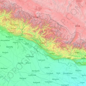
Name: Mid-Western Development Region topographic map, elevation, terrain.
Location: Mid-Western Development Region, Karnali Pradesh, Nepal (26.03861 79.08901 31.23861 84.28901)
Average elevation: 2,083 m
Minimum elevation: 56 m
Maximum elevation: 7,925 m
Other topographic maps
Click on a map to view its topography, its elevation and its terrain.
Morang
Morang District (Nepali: मोरङ जिल्ला listen) is located in Koshi Province in eastern Nepal. It is an Outer Terai district, which borders Jhapa to the east, Dhankuta and Panchthar to the north, Sunsari to the west, and Bihar, India, to the south. Morang has one metropolitan city…
Average elevation: 262 m
Sankhuwasabha
The Arun River enters from Tibet at an elevation of about 3,500 meters (11,500 feet) and flows south across the district, forming one of the world's deepest valleys relative to 8,481 meter Makalu to the west and 8,586 meter Kangchenjunga to the east.
Average elevation: 2,942 m
Kaski
The district, with Pokhara as its district headquarter, covers an area of 2,017 square km and had a total population of 492,098 according to 2011 Census. This district lies at the centroid point of the country. The altitude of Kaski district ranges from 450 meters the lowest land to 8091 meters the highest…
Average elevation: 2,565 m
Taplejung
Nepal > Eastern Development Region
Geographically Taplejung is a mountainous district located near to the world's third highest peak Kanchenjunga (8586 m). It is situated at elevation ranging from 670 metres (2,200 ft) to 8,586 metres (28,169 ft) from sea level. Tamur River is a main river in the district, which flows through the middle in the…
Average elevation: 3,894 m
Pokhara
Nepal > Gandaki Province > Kaski
Pokhara (Nepali: पोखरा, Nepali pronunciation: [ˈpokʰʌɾa]) is a metropolitan city in Nepal, which serves as the capital of Gandaki Province. It is the second most populous city of Nepal after Kathmandu, with 518,452 inhabitants living in 101,669 households in 2021. It is the country's largest…
Average elevation: 1,203 m
Far-Western Development Region
The Far-Western Region covered 19,539 square kilometers. It had nine districts with the regional headquarters at Dipayal, Doti district. The Far-Western Region was remote and developmentally challenged. Some 44% of people in the Far West Hills and 49% in the Himalayan districts lived below the poverty line.…
Average elevation: 1,858 m
Bagmati Province
Bagmati Province has an area of 20,300 km2 which is about 13.79% of the total area of Nepal. The elevation of the province ranges from 141 m at Golaghat in Chitwan District to 7,422m at Ganesh Himal. The province has an altitude low enough to support deciduous, coniferous, and alpine forests and woodlands.…
Average elevation: 2,234 m
Rupandehi
The district lies on the southern and western part of Nepal. On the East it shares border with Nawalparasi District, on West with Kapilvastu District, on North with Palpa District and on South with India. The elevation of the district lies between 100m to 1229m from sea level. The total area of the district is…
Average elevation: 182 m