
Caspian Sea topographic map
Interactive map
Click on the map to display elevation.
About this map
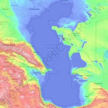
Name: Caspian Sea topographic map, elevation, terrain.
Location: Caspian Sea (36.57197 46.73944 46.98634 54.13888)
Average elevation: 390 m
Minimum elevation: -130 m
Maximum elevation: 4,335 m
Over 130 rivers provide inflow to the Caspian, with the Volga River being the largest. A second affluent, the Ural River, flows in from the north, and the Kura River flows into the sea from the west. In the past, the Amu Darya (Oxus) of Central Asia in the east often changed course to empty into the Caspian through a now-desiccated riverbed called the Uzboy River, as did the Syr Darya farther north. The Caspian also has several small islands; they are primarily located in the north and have a collective land area of roughly 2,000 km2 (770 sq mi). Adjacent to the North Caspian is the Caspian Depression, a low-lying region 27 metres (89 ft) below sea level. The Central Asian steppes stretch across the northeast coast, while the Caucasus mountains hug the western shore. The biomes to both the north and east are characterized by cold, continental deserts. Conversely, the climate to the southwest and south are generally warm with uneven elevation due to a mix of highlands and mountain ranges; the drastic changes in climate alongside the Caspian have led to a great deal of biodiversity in the region.
Other topographic maps
Click on a map to view its topography, its elevation and its terrain.
Sydney
Sydney, Council of the City of Sydney, New South Wales, Australia
Average elevation: 53 m
Perth
Australia > Western Australia > City of Perth
Perth, City of Perth, Western Australia, 6000, Australia
Average elevation: 26 m
Brisbane
Australia > Queensland > Brisbane
Brisbane, Queensland, 4000, Australia
Average elevation: 45 m
Houston
United States of America > Texas > Houston
Houston, Harris County, Texas, 77002-5902, United States of America
Average elevation: 18 m
Adelaide
Australia > South Australia > Adelaide
Adelaide, Adelaide City Council, South Australia, 5000, Australia
Average elevation: 148 m
Gold Coast
Australia > Queensland > Gold Coast
Gold Coast, Queensland, 4217, Australia
Average elevation: 42 m
Raleigh
United States of America > North Carolina > Raleigh
Raleigh, Wake County, North Carolina, 27603-1300, United States of America
Average elevation: 103 m
Townsville
Townsville, Townsville City, Queensland, 4810, Australia
Average elevation: 30 m
Byron Bay
Byron Bay, Byron Shire Council, New South Wales, 2481, Australia
Average elevation: 7 m
Russell Island
Russell Island, Greater Brisbane, Redland City, Queensland, 4184, Australia
Average elevation: 8 m
Nowra
Nowra, Shoalhaven City Council, New South Wales, 2541, Australia
Average elevation: 21 m
Coffs Harbour City Council
Coffs Harbour City Council, New South Wales, Australia
Average elevation: 207 m
Bellevue
Bellevue, City Of Swan, Western Australia, Australia
Average elevation: 23 m
Margaret River
Australia > Western Australia > Margaret River
Margaret River, Shire Of Augusta Margaret River, Western Australia, 6285, Australia
Average elevation: 94 m
City of Perth
City of Perth, Western Australia, Australia
Average elevation: 18 m
Wake County
United States > North Carolina
Wake County, North Carolina, United States
Average elevation: 96 m
Sydney
Australia > New South Wales > Sydney
Sydney, Council of the City of Sydney, New South Wales, 2000, Australia
Average elevation: 23 m
Beaverton
United States > Oregon > Washington County
Beaverton, Washington County, Oregon, United States
Average elevation: 106 m
Dubbo
Australia > New South Wales > Dubbo
Dubbo, Dubbo Regional Council, New South Wales, Australia
Average elevation: 307 m
Mackay
Mackay, Mackay Regional, Queensland, 4740, Australia
Average elevation: 13 m
Chatswood
Australia > New South Wales > Sydney
Chatswood, Lower North Shore, Sydney, Willoughby City Council, New South Wales, 2067, Australia
Average elevation: 81 m
Australia
Australia
Average elevation: 35 m
Saibai Island
Saibai Island, Torres Strait Island Regional, Queensland, Australia
Average elevation: 1 m
Sunshine Coast
Australia > Queensland > Sunshine Coast Regional
Sunshine Coast, Sunshine Coast Regional, Queensland, Australia
Average elevation: 109 m
Port Macquarie
Port Macquarie, Port Macquarie-Hastings Council, New South Wales, 2444, Australia
Average elevation: 5 m
New Zealand
New Zealand
Average elevation: 399 m
Spring Hill
USA > Florida > Spring Hill
Spring Hill, Hernando County, Florida, 34603, USA
Average elevation: 35 m
Taree
Taree, Mid-Coast Council, New South Wales, 2430, Australia
Average elevation: 17 m
Cairns
Cairns, Cairns Regional, Queensland, 4870, Australia
Average elevation: 176 m
Puyallup
United States > Washington > Pierce County
Puyallup, Pierce County, Washington, United States
Average elevation: 66 m
Mount Barker
Australia > South Australia > Mount Barker District Council
Mount Barker, Mount Barker District Council, South Australia, 5251, Australia
Average elevation: 368 m
Namche Bazaar
Nepal > Koshi Province > Solukhumbu
Namche Bazaar, Khumbupasanglahmu, Solukhumbu, Koshi Province, 56002, Nepal
Average elevation: 3,526 m
George Kendall Park Dog Off-Leash Area
Australia > New South Wales > Sydney
George Kendall Park Dog Off-Leash Area, Ermington, Sydney, City of Parramatta Council, New South Wales, 2115, Australia
Average elevation: 15 m
Adelaide
Australia > South Australia > Adelaide City Council
Adelaide, Adelaide City Council, South Australia, Australia
Average elevation: 146 m
Kangaroo Island
Australia > South Australia > Kangaroo Island Council
Kangaroo Island, Kangaroo Island Council, South Australia, Australia
Average elevation: 22 m