
Yosemite National Park topographic map
Interactive map
Click on the map to display elevation.
About this map
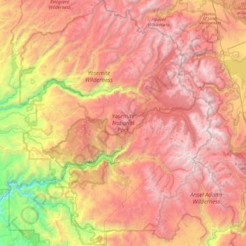
Name: Yosemite National Park topographic map, elevation, terrain.
Location: Yosemite National Park, California, 95389, United States (37.49468 -119.88610 38.18635 -119.19951)
Average elevation: 2,342 m
Minimum elevation: 483 m
Maximum elevation: 3,985 m
Yosemite is one of the largest and least fragmented habitat blocks in the Sierra Nevada, and the park supports a diversity of plants and animals. The park has an elevation range from 2,127 to 13,114 feet (648 to 3,997 m) and contains five major vegetation zones: chaparral and oak woodland, lower montane forest, upper montane forest, subalpine zone, and alpine. Of California's 7,000 plant species, approximately 50% occur in the Sierra Nevada and more than 20% are within Yosemite. The park contains suitable habitat for more than 160 rare plants, with rare local geologic formations and unique soils characterizing the restricted ranges many of these plants occupy.
Other topographic maps
Click on a map to view its topography, its elevation and its terrain.
Roseville
United States > California > Placer County
Roseville, Placer County, California, United States
Average elevation: 61 m
Redwood City
United States > California > San Mateo County
Redwood City, San Mateo County, California, United States
Average elevation: 32 m
Gillis
United States > California > San Joaquin County
Gillis, San Joaquin County, California, 95203, United States
Average elevation: -1 m
Coronado
United States > California > San Diego County
Coronado, San Diego County, California, United States
Average elevation: 5 m
Oakland
United States > California > Alameda County
Oakland, Alameda County, California, United States
Average elevation: 51 m
Pebble Beach
United States > California > Monterey County > Del Monte Forest
Pebble Beach, Del Monte Forest, Monterey County, California, 93953, United States
Average elevation: 53 m
Big Sur
United States > California > Monterey County
Big Sur, Monterey County, California, United States
Average elevation: 313 m
Arbuckle
United States > California > Colusa County
Arbuckle, Colusa County, California, 95912, United States
Average elevation: 42 m
Lake Forest
United States > California > Orange County
Lake Forest, Orange County, California, United States
Average elevation: 193 m
Crescent City
United States > California > Del Norte County
Crescent City, Del Norte County, California, United States
Average elevation: 31 m
Stanford
United States > California > Santa Clara County
Stanford, Santa Clara County, California, United States
Average elevation: 40 m
Pentland
United States > California > Kern County
Pentland, Kern County, California, United States
Average elevation: 198 m
Yosemite Valley
United States > California > Mariposa County > Yosemite Village
Yosemite Valley, Yosemite Village, Mariposa County, California, United States
Average elevation: 2,016 m
Mariposa Grove
United States > California > Mariposa County
Mariposa Grove, Mariposa County, California, United States
Average elevation: 1,865 m
Joshua Tree National Park
United States > California > Riverside County
Joshua Tree National Park, Riverside County, California, United States
Average elevation: 639 m
Fort Bragg
United States > California > Mendocino County
Fort Bragg, Mendocino County, California, United States
Average elevation: 8 m
Berkley Neighborhood Park
United States > California > Merced County > Winton
Berkley Neighborhood Park, Winton, Merced County, California, United States
Average elevation: 55 m
Brush Creek
United States > California > Butte County
Brush Creek, Butte County, California, United States
Average elevation: 957 m
Culver City
Culver City, Venice Canal Historic District, California, 90292, United States
Average elevation: 40 m
Moreno Valley
United States > California > Riverside County
Moreno Valley, Riverside County, California, United States
Average elevation: 527 m
Glacier Ridge
United States > California > Tulare County
Glacier Ridge, Tulare County, California, United States
Average elevation: 3,311 m
Brentwood
United States > California > Contra Costa County
Brentwood, Contra Costa County, California, 94513, United States
Average elevation: 27 m
Wrightwood
United States > California > San Bernardino County
Wrightwood, San Bernardino County, California, 92397, United States
Average elevation: 1,959 m
Lemon Hill
United States > California > Tulare County
Lemon Hill, Tulare County, California, United States
Average elevation: 236 m
Sausalito
United States > California > Marin County
Sausalito, Marin County, California, 94965, United States
Average elevation: 55 m
Bradley
United States > California > Monterey County
Bradley, Monterey County, California, United States
Average elevation: 190 m
Pomona
United States > California > Los Angeles County
Pomona, Los Angeles County, California, United States
Average elevation: 292 m
West Point
United States > California > Calaveras County
West Point, Calaveras County, California, 95255, United States
Average elevation: 794 m
Salton Sea
United States > California > Imperial County
Salton Sea, Imperial County, California, United States
Average elevation: 9 m
See Canyon
United States > California > San Luis Obispo County
See Canyon, San Luis Obispo County, California, United States
Average elevation: 242 m
Agoura Hills
United States > California > Los Angeles County
Agoura Hills, Los Angeles County, California, 91301, United States
Average elevation: 332 m
Lassen County
Lassen County, California, United States
Average elevation: 1,572 m
Pleasure Point
United States > California > Santa Cruz County
Pleasure Point, Santa Cruz County, California, United States
Average elevation: 6 m
Devils Peak
United States > California > Placer County
Devils Peak, Placer County, California, United States
Average elevation: 2,042 m
Yokuts Valley
United States > California > Fresno County
Yokuts Valley, Fresno County, California, 93675, United States
Average elevation: 550 m
Mount Gibson
United States > California > Tuolumne County
Mount Gibson, Tuolumne County, California, United States
Average elevation: 2,322 m
Los Angeles
United States > California > Los Angeles County
Los Angeles, Los Angeles County, California, United States
Average elevation: 241 m
West Highlands
United States > California > San Bernardino County
West Highlands, San Bernardino County, California, 92369, United States
Average elevation: 414 m
Elk Grove
United States > California > Sacramento County
Elk Grove, Sacramento County, California, 95624, United States
Average elevation: 17 m
San Joaquin River
United States > California > Stanislaus County
San Joaquin River, Stanislaus County, California, United States
Average elevation: 15 m
Bluewater
United States > California > San Bernardino County
Bluewater, San Bernardino County, California, United States
Average elevation: 147 m
Indio
United States > California > Riverside County
Indio, Riverside County, California, United States
Average elevation: 74 m
East Palo Alto
United States > California > San Mateo County
East Palo Alto, San Mateo County, CAL Fire Northern Region, California, United States
Average elevation: 4 m
Alpine
United States > California > San Diego County
Alpine, San Diego County, CAL Fire Southern Region, California, 91901, United States
Average elevation: 581 m
Livermore
United States > California > Alameda County
Livermore, Alameda County, CAL Fire Northern Region, California, 94550, United States
Average elevation: 184 m
Parkwood
United States > California > Madera County > Parkwood
Parkwood, Madera County, CAL Fire Southern Region, California, United States
Average elevation: 81 m
Vacaville
United States > California > Solano County
Vacaville, Solano County, CAL Fire Northern Region, California, United States
Average elevation: 90 m
Armona
United States > California > Kings County
Armona, Kings County, California, 93202, United States
Average elevation: 70 m
Signal Hill
United States > California > Los Angeles County
Signal Hill, Los Angeles County, California, United States
Average elevation: 28 m
Sam Alba Memorial Park
United States > California > San Bernardino County > Ontario
Sam Alba Memorial Park, Ontario, San Bernardino County, California, 91761, United States
Average elevation: 296 m