
Himachal Pradesh topographic map
Interactive map
Click on the map to display elevation.
About this map
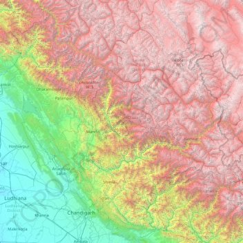
Name: Himachal Pradesh topographic map, elevation, terrain.
Location: Himachal Pradesh, India (30.37717 75.59401 33.25567 79.01238)
Average elevation: 2,869 m
Minimum elevation: 232 m
Maximum elevation: 6,687 m
Due to extreme variation in elevation, great variation occurs in the climatic conditions of Himachal Pradesh. The climate varies from hot and humid subtropical in the southern tracts to, with more elevation, cold, alpine, and glacial in the northern and eastern mountain ranges. The state's winter capital, Dharamsala receives very heavy rainfall, while areas like Lahaul and Spiti are cold and almost rainless. Broadly, Himachal experiences three seasons: summer, winter, and rainy season. Summer lasts from mid-April until the end of June and most parts become very hot (except in the alpine zone which experiences a mild summer) with the average temperature ranging from 28 to 32 °C (82 to 90 °F). Winter lasts from late November until mid-March. Snowfall is common in alpine tracts. Pollution is affecting the climate of almost all the states of India. Due to steps taken by governments to prevent pollution, Himachal Pradesh has become the first smoke-free state in India which means cooking in the entire state is free of traditional chulhas.
Other topographic maps
Click on a map to view its topography, its elevation and its terrain.
Saura
India > Madhya Pradesh > Ater Tahsil > Mallapura
Saura, Mallapura, Ater Tahsil, Bhind District, Madhya Pradesh, India
Average elevation: 142 m
Dharamshala
India > Himachal Pradesh > Dharamshala
Dharamshala, Kangra District, Himachal Pradesh, 176200, India
Average elevation: 1,781 m
Bangalore East
Bangalore East, Bengaluru Urban, Karnataka, India
Average elevation: 889 m
Coimbatore
India > Tamil Nadu > Coimbatore North
Coimbatore, Coimbatore North, Coimbatore District, Tamil Nadu, 641001, India
Average elevation: 452 m
Lucknow
India > Uttar Pradesh > Lucknow
Lucknow, Lucknow District, Uttar Pradesh, 226027, India
Average elevation: 120 m
Mohali
India > Madhya Pradesh > Rehli Tahsil
Mohali, Rehli Tahsil, Sagar District, Madhya Pradesh, India
Average elevation: 430 m
Dharav Parav
India > Madhya Pradesh > Bankhedi Tahsil
Dharav Parav, Bankhedi Tahsil, Narmadapuram District, Madhya Pradesh, India
Average elevation: 378 m
Kashipur
India > Uttarakhand > Kashipur
Kashipur, Udham Singh Nagar District, Uttarakhand, 244713, India
Average elevation: 233 m
Bhagsu
India > Himachal Pradesh > Dharamshala
Bhagsu, Dharamshala, Kangra District, Himachal Pradesh, 176219, India
Average elevation: 1,955 m
Tholpetty
India > Kerala > Mananthavady
Tholpetty, Mananthavady, Wayanad District, Kerala, 571250, India
Average elevation: 875 m
Rampura
India > Gujarat > Detroj Rampura Taluka
Rampura, Detroj Rampura Taluka, Ahmedabad District, Gujarat, 382140, India
Average elevation: 42 m
Dantiwada dam
India > Gujarat > Dantiwada Taluka > Dantiwada
Dantiwada dam, Dantiwada, Dantiwada Taluka, Banaskantha District, Gujarat, 385505, India
Average elevation: 170 m
Gullah
India > Punjab > Guruharsahai Tahsil
Gullah, Guruharsahai Tahsil, Firozpur District, Punjab, 152024, India
Average elevation: 187 m
Machilipatnam
India > Andhra Pradesh > Machilipatnam
Machilipatnam, Krishna, Andhra Pradesh, 521001, India
Average elevation: 4 m
Thrikkunnapuzha
India > Kerala > Karthikappally
Thrikkunnapuzha, Karthikappally, Alappuzha District, Kerala, 690516, India
Average elevation: 2 m
Jaipur
India > Rajasthan > Jaipur Tehsil
Jaipur, Jaipur Municipal Corporation, Jaipur Tehsil, Jaipur, Rajasthan, 302001, India
Average elevation: 408 m
Maranda
India > Madhya Pradesh > Baihar Tahsil
Maranda, Baihar Tahsil, Balaghat District, Madhya Pradesh, India
Average elevation: 641 m
Waruda
India > Maharashtra > Teosa
Waruda, Teosa, Amravati, Maharashtra, India
Average elevation: 335 m
Mundi
India > Madhya Pradesh > Damoh Tahsil
Mundi, Damoh Tahsil, Damoh District, Madhya Pradesh, India
Average elevation: 364 m
Galore
Galore, Hamirpur District, Himachal Pradesh, 177006, India
Average elevation: 693 m
Suryapet
India > Telangana > Suryapet mandal
Suryapet, Suryapet mandal, Suryapet District, Telangana, 508213, India
Average elevation: 180 m
Vallapuzha
Vallapuzha, Pattambi, Palakkad District, Kerala, 679335, India
Average elevation: 56 m
Jaynagar - I
Jaynagar - I, South 24 Parganas District, West Bengal, India
Average elevation: 4 m
Bargara
India > Madhya Pradesh > Chitrangi Tahsil
Bargara, Chitrangi Tahsil, Singrauli District, Madhya Pradesh, India
Average elevation: 211 m
Kerla
India > Rajasthan > Pali Tehsil
Kerla, Pali Tehsil, Pali District, Rajasthan, India
Average elevation: 199 m
Rajkot
India > Gujarat > Rajkot East Taluka
Rajkot, Rajkot East Taluka, Rajkot District, Gujarat, 360001, India
Average elevation: 141 m
Bering
India > Punjab > Mukerian Tahsil
Bering, Mukerian Tahsil, Hoshiarpur District, Punjab, 144223, India
Average elevation: 622 m
Papan
India > Madhya Pradesh > Seoni-Malwa Tahsil
Papan, Seoni-Malwa Tahsil, Narmadapuram District, Madhya Pradesh, India
Average elevation: 281 m
Puducherry
India > Puducherry > Puducherry Taluk
Puducherry, Puducherry Taluk, Puducherry District, Puducherry, 605001, India
Average elevation: 10 m
Malak
India > Punjab > Kharar Tahsil
Malak, Kharar Tahsil, Sahibzada Ajit Singh Nagar District, Punjab, 140901, India
Average elevation: 352 m
Tharwa
India > Madhya Pradesh > Harrai Tahsil
Tharwa, Harrai Tahsil, Chhindwara District, Madhya Pradesh, India
Average elevation: 644 m
Sukma
India > Chhattisgarh > Sukma Tahsil
Sukma, Sukma Tahsil, Sukma District, Chhattisgarh, 494111, India
Average elevation: 219 m