
Sekong Province topographic map
Interactive map
Click on the map to display elevation.
About this map
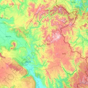
Name: Sekong Province topographic map, elevation, terrain.
Location: Sekong Province, Laos (15.02836 106.30008 16.18952 107.63500)
Average elevation: 771 m
Minimum elevation: 94 m
Maximum elevation: 2,170 m
The Dakchung Plateau is an Important Bird Area (IBA). It is 5,140 ha in size, and at an elevation of 800–1,400 metres (2,600–4,600 ft). The habitat is characterized as pine woodland, grassland, degraded semi-evergreen forest, dry evergreen forest, marshy land, and tall grasses areas. Of the avifauna, the yellow-billed nuthatch (Sitta solangiae) is classified as near threatened, while the black-crowned barwing (Actinodura sodangorum) is classified as vulnerable. Other fauna include the Oriental small-clawed otter (Aonyx cinerea), tiger (Panthera tigris), big-headed turtle (Platysternon megacephalum), and herds of Asian elephant (Elephas maximus).
Other topographic maps
Click on a map to view its topography, its elevation and its terrain.
Him
Laos > Houaphanh > Xam Neua District
Him, Xam Neua District, Houaphanh, Laos
Average elevation: 897 m
Don
Laos > Sekong Province > Kaleum District
Don, Kaleum District, Sekong Province, Laos
Average elevation: 436 m
Chommanytai
Laos > Vientiane Prefecture > Xaysetha District > Vientiane Capital
Chommanytai, Vientiane Capital, Xaysetha District, Vientiane Prefecture, 21001, Laos
Average elevation: 172 m
Ban Khiau
Laos > Khammouane > Yommalath District
Ban Khiau, Yommalath District, Khammouane, Laos
Average elevation: 203 m
Golden Triangle Special Economic Zone
Laos > Bokeo Province > Tonpheung District
Golden Triangle Special Economic Zone, Tonpheung District, Bokeo Province, Laos
Average elevation: 407 m
Parkngum District
Parkngum District, Vientiane Prefecture, Laos
Average elevation: 248 m
Naka
Laos > Houaphanh > Sop Bao District
Naka, Sop Bao District, Houaphanh, Laos
Average elevation: 337 m
Bachiangchaleunsouk District
Bachiangchaleunsouk District, Champasak Province, Laos
Average elevation: 394 m
Miam
Laos > Xiangkhouang Province > Phou Kout District
Miam, Phou Kout District, Xiangkhouang Province, Laos
Average elevation: 890 m
Hinhurp District
Hinhurp District, Vientiane Province, 01000, Laos
Average elevation: 308 m
Kham District
Laos > Xiangkhouang Province > Kham District
Kham District, Xiangkhouang Province, Laos
Average elevation: 1,083 m
Keo
Laos > Xiangkhouang Province > Pek District
Keo, Pek District, Xiangkhouang Province, Laos
Average elevation: 1,203 m
Bridge View Point
Laos > Luang Prabang > Luang Prabang District > Thapene
Bridge View Point, 2501, Thapene, Luang Prabang District, Luang Prabang, Laos
Average elevation: 521 m
Na Sam Phanh
Laos > Sainyabuli Province > Phiang District > Na Sam Phanh
Na Sam Phanh, Phiang District, Sainyabuli Province, Laos
Average elevation: 521 m
Muang Kham
Laos > Xiangkhouang Province > Phou Kout District
Muang Kham, Phou Kout District, Xiangkhouang Province, Laos
Average elevation: 762 m
Vientiane Capital
Laos > Vientiane Prefecture > Chanthabuly District
Vientiane Capital, Chanthabuly District, Vientiane Prefecture, Laos
Average elevation: 187 m
Thakhek
Laos > Khammouane > Thakhek
Thakhek, Thakhek District, Khammouane, 12000, Laos
Average elevation: 179 m
Ban Phontiou
Laos > Khammouane > Ban Phontiou
Ban Phontiou, Hineboune District, Khammouane, Laos
Average elevation: 199 m
ທົ່ງປົງ
Laos > Vientiane Prefecture > ທົ່ງປົງ
ທົ່ງປົງ, Vientiane Capital, Sikhottabong District, Vientiane Prefecture, Laos
Average elevation: 174 m
Don-Kao
Laos > Luang Prabang > Don-Kao
Don-Kao, Luang Prabang District, Luang Prabang, 0600, Laos
Average elevation: 320 m
Mout
Laos > Luang Prabang > Mout
Mout, Xiengngeun District, Luang Prabang, Laos
Average elevation: 380 m
Sibounheuang
Laos > Vientiane Prefecture > Sibounheuang
Sibounheuang, Vientiane Capital, Chanthabuly District, Vientiane Prefecture, 01009, Laos
Average elevation: 171 m
Khone Phapheng Falls
Khone Phapheng Falls, Khong District, Champasak Province, Laos
Average elevation: 74 m
Chong
Laos > Salavan Province > Vapy District > Chong
Chong, Vapy District, Salavan Province, Laos
Average elevation: 170 m
Phonthong District
Phonthong District, Champasak Province, Laos
Average elevation: 157 m
Luang Prabang
Laos > Luang Prabang > Luang Prabang District
Luang Prabang, Luang Prabang District, Luang Prabang, 10000, Laos
Average elevation: 557 m
Phanom
Laos > Luang Prabang > Luang Prabang District
Phanom, Luang Prabang District, Luang Prabang, 10000, Laos
Average elevation: 330 m
Muang Kham
Laos > Xiangkhouang Province > Muang Kham
Muang Kham, Kham District, Xiangkhouang Province, Laos
Average elevation: 642 m