
Long Island topographic map
Interactive map
Click on the map to display elevation.
About this map
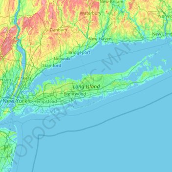
Name: Long Island topographic map, elevation, terrain.
Location: Long Island, New York, United States (40.54190 -74.04197 41.16116 -71.85627)
Average elevation: 42 m
Minimum elevation: -5 m
Maximum elevation: 498 m
The land to the south of this moraine to the South Shore is the outwash plain of the last glacier. One part of the outwash plain was known as the Hempstead Plains, and this land contained one of the few natural prairies to exist east of the Appalachian Mountains. The glaciers melted and receded to the north, resulting in the difference between the topography of the North Shore beaches and the South Shore beaches. The North Shore beaches are rocky from the remaining glacial debris, while the South Shore's are crisp, clear, outwash sand. Jayne's Hill, at 401 feet (122 m), within Suffolk County near its border with Nassau County, is the highest hill along either moraine; another well-known summit is Bald Hill in Brookhaven Town, not far from its geographical center at Middle Island. The glaciers also formed Lake Ronkonkoma in Suffolk County and Lake Success in Nassau County, each a deep kettle lake.
Other topographic maps
Click on a map to view its topography, its elevation and its terrain.
Rudeston
United States > New York > Hamilton County
Rudeston, Town of Arietta, Hamilton County, New York, United States
Average elevation: 533 m
Town of Perry
United States > New York > Wyoming County
Town of Perry, Wyoming County, New York, 14530, United States
Average elevation: 403 m
City of Ogdensburg
United States > New York > Saint Lawrence County
City of Ogdensburg, Saint Lawrence County, New York, United States
Average elevation: 85 m
Terpening Corners
United States > New York > Tompkins County > South Lansing
Terpening Corners, South Lansing, Town of Lansing, Tompkins County, New York, United States
Average elevation: 288 m
Sequoia Tree
United States > New York > New York County > New York
Sequoia Tree, Morningside Avenue, Manhattan Community Board 9, Manhattan, New York County, New York, 10027, United States
Average elevation: 19 m
Cecil Park
United States > New York > Westchester County > City of Yonkers
Cecil Park, City of Yonkers, Westchester County, New York, 10707, United States
Average elevation: 70 m
Roslyn Heights
United States > New York > Nassau County
Roslyn Heights, Town of North Hempstead, Nassau County, New York, United States
Average elevation: 48 m
Village of Potsdam
United States > New York > Saint Lawrence County > Town of Potsdam
Village of Potsdam, Town of Potsdam, Saint Lawrence County, New York, 13699, United States
Average elevation: 133 m
Village of Middleville
United States > New York > Herkimer County
Village of Middleville, Town of Fairfield, Herkimer County, New York, United States
Average elevation: 227 m
Village of Mill Neck
United States > New York > Nassau County
Village of Mill Neck, Town of Oyster Bay, Nassau County, New York, 11765, United States
Average elevation: 19 m
Tillson
United States > New York > Ulster County > Town of Rosendale
Tillson, Town of Rosendale, Ulster County, New York, 12486, United States
Average elevation: 58 m
Cuddebackville
United States > New York > Orange County
Cuddebackville, Town of Deerpark, Orange County, New York, 12729, United States
Average elevation: 216 m
Town of Monroe
United States > New York > Orange County
Town of Monroe, Orange County, New York, United States
Average elevation: 229 m
Chester Heights
United States > New York > Westchester County > City of New Rochelle
Chester Heights, City of New Rochelle, Westchester County, New York, 10801, United States
Average elevation: 36 m
North Patchogue
United States > New York > Suffolk County > Town of Brookhaven
North Patchogue, Town of Brookhaven, Suffolk County, New York, United States
Average elevation: 15 m
Village of Thomaston
United States > New York > Nassau County
Village of Thomaston, Town of North Hempstead, Nassau County, New York, United States
Average elevation: 35 m
Horton Falls
United States > New York > Albany County > Town of New Scotland
Horton Falls, Town of New Scotland, Albany County, New York, 12159, United States
Average elevation: 88 m
South Huntington
United States > New York > Suffolk County > Town of Huntington
South Huntington, Town of Huntington, Suffolk County, New York, 11746, United States
Average elevation: 60 m
Bloomington
United States > New York > Ulster County > Town of Rosendale
Bloomington, Town of Rosendale, Ulster County, New York, 12411, United States
Average elevation: 61 m
City of Batavia
United States > New York > Genesee County
City of Batavia, Genesee County, New York, 14020, United States
Average elevation: 275 m
Village of Lake Placid
United States > New York > Essex County
Village of Lake Placid, Town of North Elba, Essex County, New York, 12946, United States
Average elevation: 558 m
Mount Upton
United States > New York > Chenango County > Town of Guilford
Mount Upton, Town of Guilford, Town of Norwich, Chenango County, New York, 13809, United States
Average elevation: 387 m
Syosset
United States > New York > Nassau County
Syosset, Town of Oyster Bay, Nassau County, New York, 11791, United States
Average elevation: 67 m
Town of Moira
United States > New York > Franklin County
Town of Moira, Franklin County, New York, United States
Average elevation: 125 m
South Wales
United States > New York > Erie County
South Wales, Town of Wales, Erie County, New York, 14139, United States
Average elevation: 361 m
Village of Waddington
United States > New York > Saint Lawrence County
Village of Waddington, Town of Waddington, Saint Lawrence County, New York, 13694, United States
Average elevation: 80 m
Coopers Plains
United States > New York > Steuben County
Coopers Plains, Town of Erwin, Steuben County, New York, 14827, United States
Average elevation: 348 m
Mahopac
United States > New York > Putnam County > Town of Carmel
Mahopac, Town of Carmel, Putnam County, New York, United States
Average elevation: 201 m
Sycaway
United States > New York > Rensselaer County > Town of Brunswick
Sycaway, Town of Brunswick, Rensselaer County, New York, 12180, United States
Average elevation: 116 m
Village of Walden
United States > New York > Orange County
Village of Walden, Town of Montgomery, Orange County, New York, 12586, United States
Average elevation: 114 m
Town of Amherst
United States > New York > Erie County
Town of Amherst, Erie County, New York, United States
Average elevation: 184 m
East Patchogue
United States > New York > Suffolk County > Town of Brookhaven
East Patchogue, Town of Brookhaven, Suffolk County, New York, 11772, United States
Average elevation: 10 m
Town of Guilderland
United States > New York > Albany County
Town of Guilderland, Albany County, New York, United States
Average elevation: 126 m
Dutch Settlement
United States > New York > Oswego County > Town of West Monroe
Dutch Settlement, Town of West Monroe, Oswego County, New York, 13167, United States
Average elevation: 148 m
Sandy Beach
United States > New York > Erie County > Town of Grand Island
Sandy Beach, Town of Grand Island, Erie County, New York, 14304, United States
Average elevation: 175 m
Town of Philipstown
United States > New York > Putnam County
Town of Philipstown, Putnam County, New York, United States
Average elevation: 178 m
Lee
United States > New York > Washington County > Town of Cambridge
Lee, Town of Cambridge, Washington County, New York, 12028, United States
Average elevation: 150 m
City of Glen Cove
United States > New York > Nassau County
City of Glen Cove, Nassau County, New York, United States
Average elevation: 12 m
Albany & School Triangle
United States > New York > Erie County > Buffalo
Albany & School Triangle, Buffalo, Erie County, New York, United States
Average elevation: 188 m
Black Creek Village
United States > New York > Niagara County > City of Niagara Falls
Black Creek Village, City of Niagara Falls, Niagara County, New York, 14304, United States
Average elevation: 176 m
West Point
United States > New York > Suffolk County > Hampton Bays > Town of Southampton > Rampasture
West Point, Rampasture, Hampton Bays, Town of Southampton, Suffolk County, New York, 11946, United States
Average elevation: 3 m
Garrison
United States > New York > Putnam County
Garrison, Town of Philipstown, Putnam County, New York, 10996, United States
Average elevation: 77 m
City of Kingston
United States > New York > Ulster County
City of Kingston, Ulster County, New York, 12401, United States
Average elevation: 52 m
Town of Hampton
United States > New York > Washington County
Town of Hampton, Washington County, New York, 12837, United States
Average elevation: 170 m
Village of Kings Point
United States > New York > Nassau County
Village of Kings Point, Town of North Hempstead, Nassau County, New York, 11024, United States
Average elevation: 9 m
Town of Newcomb
United States > New York > Essex County
Town of Newcomb, Essex County, New York, 12852, United States
Average elevation: 627 m
New City
United States > New York > Rockland County
New City, Town of Clarkstown, Rockland County, New York, 10956, United States
Average elevation: 89 m
Town of Sandy Creek
United States > New York > Oswego County
Town of Sandy Creek, Oswego County, New York, United States
Average elevation: 161 m
Rockton
United States > New York > Montgomery County > City of Amsterdam
Rockton, City of Amsterdam, Montgomery County, New York, 12010, United States
Average elevation: 185 m
City of White Plains
United States > New York > Westchester County
City of White Plains, Westchester County, New York, United States
Average elevation: 83 m