
Otago topographic map
Interactive map
Click on the map to display elevation.
About this map
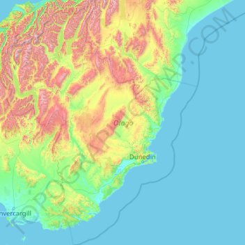
Name: Otago topographic map, elevation, terrain.
Location: Otago, New Zealand (-46.83936 168.11639 -43.95541 171.41813)
Average elevation: 348 m
Minimum elevation: -2 m
Maximum elevation: 2,681 m
Other topographic maps
Click on a map to view its topography, its elevation and its terrain.
Mount Tūtoko
New Zealand > Southland > Southland District > Fiordland Community
Average elevation: 1,892 m
Kawarau Gorge
New Zealand > Otago > Central Otago District > Cromwell Community
Average elevation: 339 m
Ohai
New Zealand > Southland > Southland District > Wallace Takitimu Community
Average elevation: 188 m
Māhoenui
New Zealand > Waikato > Waitomo District
Māhoenui is located in the King Country approx 50 kilometres (31 mi) inland from the west coast of the North Island, the topography is hilly to mountainous, with small alluvial areas near the streams and river.
Average elevation: 113 m
Te Haumi
New Zealand > Northland > Far North District > Bay of Islands-Whangaroa Community > Paihia
Average elevation: 34 m
Tōtara North
New Zealand > Northland > Far North District > Bay of Islands-Whangaroa Community
Average elevation: 67 m
Waiouru
New Zealand > Manawatu-Whanganui > Ruapehu District
Because of its high altitude and close proximity to Mt Ruapehu, Waiouru's climate is cold throughout the year, unlike other North Island centres, and particularly cold when the wind blows from the mountain. The Desert Road is regularly closed in winter owing to heavy snowfalls. Waiouru's climate can be…
Average elevation: 817 m
Methven
New Zealand > Canterbury > Ashburton District
Methven (Māori: Piwakawaka) is a small town in the Canterbury region of the South Island of New Zealand. It is located near the western edge of the Canterbury Plains, 35 km (22 mi) north of Ashburton and 95 km (59 mi) west of Christchurch, and at an elevation of 320 m (1,050 ft). The town is a service centre…
Average elevation: 322 m
Forest Range
New Zealand > Southland > Southland District > Waihopai Toetoe Community
Average elevation: 373 m
Pearce
New Zealand > Canterbury > Christchurch City > Banks Peninsula Community
Average elevation: 485 m