
Switzerland topographic map
Interactive map
Click on the map to display elevation.
About this map
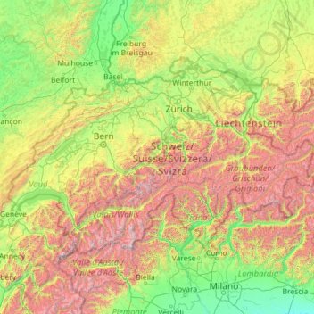
Name: Switzerland topographic map, elevation, terrain.
Location: Switzerland (45.81797 5.95591 47.80846 10.49229)
Average elevation: 1,016 m
Minimum elevation: 41 m
Maximum elevation: 4,564 m
Switzerland lies between latitudes 45° and 48° N, and longitudes 5° and 11° E. It contains three basic topographical areas: the Swiss Alps to the south, the Swiss Plateau or Central Plateau, and the Jura mountains on the west. The Alps are a mountain range running across the central and south of the country, constituting about 60% of the country's area. The majority of the population live on the Swiss Plateau. The Swiss Alps host many glaciers, covering 1,063 square kilometres (410 sq mi). From these originate the headwaters of several major rivers, such as the Rhine, Inn, Ticino and Rhône, which flow in the four cardinal directions, spreading across Europe. The hydrographic network includes several of the largest bodies of fresh water in Central and Western Europe, among which are Lake Geneva (Lac Léman in French), Lake Constance (Bodensee in German) and Lake Maggiore. Switzerland has more than 1500 lakes and contains 6% of Europe's freshwater stock. Lakes and glaciers cover about 6% of the national territory. Lake Geneva is the largest lake and is shared with France. The Rhône is both the main source and outflow of Lake Geneva. Lake Constance is the second-largest and, like Lake Geneva, an intermediate step by the Rhine at the border with Austria and Germany. While the Rhône flows into the Mediterranean Sea at the French Camargue region and the Rhine flows into the North Sea at Rotterdam, about 1,000 kilometres (620 miles) apart, both springs are only about 22 kilometres (14 miles) apart in the Swiss Alps.
Other topographic maps
Click on a map to view its topography, its elevation and its terrain.
Sydney
Sydney, Council of the City of Sydney, New South Wales, Australia
Average elevation: 53 m
Brisbane
Australia > Queensland > Brisbane
Brisbane, Queensland, 4000, Australia
Average elevation: 45 m
Perth
Australia > Western Australia > City of Perth
Perth, City of Perth, Western Australia, 6000, Australia
Average elevation: 26 m
Adelaide
Australia > South Australia > Adelaide
Adelaide, Adelaide City Council, South Australia, 5000, Australia
Average elevation: 148 m
Sydney
Australia > New South Wales > Sydney
Sydney, Council of the City of Sydney, New South Wales, 2000, Australia
Average elevation: 23 m
Manly
Australia > New South Wales > Sydney
Manly, Sydney, Northern Beaches Council, New South Wales, 2095, Australia
Average elevation: 17 m
Australia
Australia
Average elevation: 35 m
Launceston
Australia > Tasmania > Launceston
Launceston, Tasmania, 7250, Australia
Average elevation: 218 m
Raleigh
United States of America > North Carolina > Raleigh
Raleigh, Wake County, North Carolina, 27603-1300, United States of America
Average elevation: 103 m
Wake County
United States > North Carolina
Wake County, North Carolina, United States
Average elevation: 96 m
Fargo
United States > North Dakota > Cass County
Fargo, Cass County, North Dakota, United States
Average elevation: 277 m
Mudgee
Mudgee, Mid-Western Regional Council, New South Wales, 2850, Australia
Average elevation: 535 m
Sunshine Coast
Australia > Queensland > Sunshine Coast Regional
Sunshine Coast, Sunshine Coast Regional, Queensland, Australia
Average elevation: 109 m
Newcastle
Australia > New South Wales > Newcastle
Newcastle, Newcastle-Maitland, Newcastle City Council, New South Wales, 2300, Australia
Average elevation: 5 m
Atherton
Atherton, Tablelands Regional, Queensland, 4883, Australia
Average elevation: 811 m
Eltham District
Australia > Victoria > Greensborough
Eltham District, Greensborough, City of Banyule, Victoria, Australia
Average elevation: 85 m
City of Perth
City of Perth, Western Australia, Australia
Average elevation: 18 m
Adelaide Hills Council
Adelaide Hills Council, South Australia, Australia
Average elevation: 305 m
Hervey Bay
Hervey Bay, Fraser Coast Regional, Queensland, 4655, Australia
Average elevation: 6 m
Gold Coast
Australia > Queensland > Gold Coast
Gold Coast, Queensland, 4217, Australia
Average elevation: 42 m
Armidale
Armidale, Armidale Regional Council, New South Wales, 2350, Australia
Average elevation: 1,036 m
Orange
Orange, Orange City Council, New South Wales, 2800, Australia
Average elevation: 852 m
Litchfield County
United States > Connecticut > Northwest Hills Planning Region
Litchfield County, Northwest Hills Planning Region, Connecticut, United States
Average elevation: 252 m
Yarra Ranges National Park
Australia > Victoria > Melbourne
Yarra Ranges National Park, Reefton, Melbourne, Shire of Yarra Ranges, Victoria, Australia
Average elevation: 465 m
Townsville
Townsville, Townsville City, Queensland, 4810, Australia
Average elevation: 30 m
Epping
Australia > New South Wales > Sydney
Epping, Sydney, City of Parramatta Council, New South Wales, 2121, Australia
Average elevation: 96 m
Wollongong
Australia > New South Wales > Wollongong
Wollongong, Wollongong City Council, New South Wales, 2500, Australia
Average elevation: 115 m
Troisvilles
France > Hauts-de-France > Nord
Troisvilles, Cambrai, Nord, Hauts-de-France, Metropolitan France, 59980, France
Average elevation: 132 m
Dirk Hartog Island
Dirk Hartog Island, Western Australia, Australia
Average elevation: 5 m
Wuruma Dam
Wuruma Dam, North Burnett Regional, Queensland, Australia
Average elevation: 273 m
City of Victor Harbor
City of Victor Harbor, South Australia, 5211, Australia
Average elevation: 148 m
Buderim
Australia > Queensland > Sunshine Coast Regional
Buderim, Sunshine Coast Regional, Queensland, 4556, Australia
Average elevation: 32 m
Mount Gravatt
Mount Gravatt, Greater Brisbane, Queensland, 4122, Australia
Average elevation: 70 m
Brisbane River
Brisbane River, Queensland, 4104, Australia
Average elevation: 235 m