
Yokohama topographic map
Interactive map
Click on the map to display elevation.
About this map
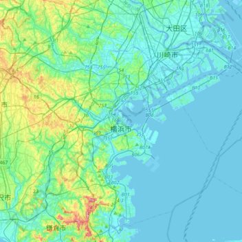
Name: Yokohama topographic map, elevation, terrain.
Location: Yokohama, Kanagawa Prefecture, 231-0017, Japan (35.31250 139.46478 35.59285 139.77693)
Average elevation: 23 m
Minimum elevation: -9 m
Maximum elevation: 146 m
Yokohama has a total area of 437.38 km2 (168.87 sq mi) at an elevation of 5 metres (16 ft) above sea level. It is the capital of Kanagawa Prefecture, bordered to the east by Tokyo Bay and located in the middle of the Kantō plain. The city is surrounded by hills and the characteristic mountain system of the island of Honshū, so its growth has been limited and it has had to gain ground from the sea. This also affects the population density, one of the highest in Japan with 8,500 inhabitants per km2.
Other topographic maps
Click on a map to view its topography, its elevation and its terrain.
Rusutsu
Rusutsu, Abuta County, Shiribeshi Subprefecture, Hokkaido Prefecture, Japan
Average elevation: 389 m
Ōsumi Islands
Ōsumi Islands, Kumage County, Kagoshima Prefecture, Japan
Average elevation: 29 m
Okinoerabujima
Japan > Oshima County > Wadomari
Okinoerabujima, Wadomari, Oshima County, Kagoshima Prefecture, Japan
Average elevation: 20 m
Shirakawa
Shirakawa, Ono County, Gifu Prefecture, Chubu Region, Japan
Average elevation: 1,207 m
Nakauonuma County
Nakauonuma County, Niigata Prefecture, Chubu Region, Japan
Average elevation: 605 m
Hakuba
Hakuba, Kita-Azumi County, Nagano Prefecture, Japan
Average elevation: 1,120 m
大島
Japan > Matsumae County > Matsumae
大島, Oshima, Matsumae, Matsumae County, Oshima Subprefecture, Hokkaido Prefecture, 049-1500, Japan
Average elevation: 157 m
Yusuhara
Yusuhara, Takaoka County, Kochi Prefecture, Japan
Average elevation: 662 m
Hashima Island
Hashima Island, Iwakuni, Yamaguchi Prefecture, Japan
Average elevation: 3 m
Naraha
Naraha, Futaba County, Fukushima Prefecture, Japan
Average elevation: 183 m
Obira
Obira, Rumoi County, Rumoi Subprefecture, Hokkaido Prefecture, Japan
Average elevation: 117 m
Jigoku-dani Valley
Japan > Kamikawa County > Higashikawa
Jigoku-dani Valley, Higashikawa, Kamikawa County, Kamikawa Subprefecture, Hokkaido Prefecture, Japan
Average elevation: 1,796 m
Mount Fuji
Japan > Sunto County > Oyama
Mount Fuji, Oyama, Sunto County, Shizuoka Prefecture, Chubu Region, Japan
Average elevation: 3,261 m
Ginan
Ginan, Hashima County, Gifu Prefecture, 501-6197, Japan
Average elevation: 13 m